Elter Water: Difference between revisions
No edit summary |
No edit summary |
||
| (One intermediate revision by the same user not shown) | |||
| Line 1: | Line 1: | ||
{{county|Westmorland}} | {{county|Westmorland}} | ||
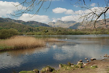
[[File:Elterwater and Langdale.jpg|right|thumb|350px|Elter Water with the Langdale Pikes behind]] | [[File:Elterwater and Langdale.jpg|right|thumb|350px|Elter Water with the Langdale Pikes behind]] | ||
''' | '''Elter Water''' is a small lake within the [[Lake District]] on the border of [[Westmorland]] with [[Lancashire]]; the lake shore is almost wholly in Westmorland but Lancashire reaches so that its northernmost point is here in the lake. | ||
In a splendid setting, which draws many visitors, Elter Water stands at the entrance to Great Langdale, one of the most scenic valleys of the Lake District. It is flanked by afforested slopes and high moorland and from here the view climbs up to the [[Langdale Pikes]]. Some of the shoreline belongs to the [[NTE|National Trust]] | In a splendid setting, which draws many visitors, Elter Water stands at the entrance to Great Langdale, one of the most scenic valleys of the Lake District. It is flanked by afforested slopes and high moorland and from here the view climbs up to the [[Langdale Pikes]]. Some of the shoreline belongs to the [[NTE|National Trust]]. | ||
Half a mile | Half a mile north-west of the water is the village of [[Elterwater]], also in [[Great Langdale]]. Just to the north of the Langdale valley can be found the slightly larger village of [[Chapel Stile]]. | ||
The lake is 1,030 yards long and varies in width up to a maximum of 350 yards, and it covers an area of | The lake is 1,030 yards long and varies in width up to a maximum of 350 yards, and it covers an area of 38 acres. It has a maximum depth of 20 feet and lies at 187 feet above sea level. | ||
The river [[Brathay]] flows out of Elter Water, whence it flows south to join [[Windermere]], near [[Ambleside]].<ref name=parker37/> | The river [[Brathay]] flows out of Elter Water, whence it flows south to join [[Windermere]], near [[Ambleside]].<ref name=parker37/> | ||
Latest revision as of 18:09, 15 November 2018

Elter Water is a small lake within the Lake District on the border of Westmorland with Lancashire; the lake shore is almost wholly in Westmorland but Lancashire reaches so that its northernmost point is here in the lake.
In a splendid setting, which draws many visitors, Elter Water stands at the entrance to Great Langdale, one of the most scenic valleys of the Lake District. It is flanked by afforested slopes and high moorland and from here the view climbs up to the Langdale Pikes. Some of the shoreline belongs to the National Trust.
Half a mile north-west of the water is the village of Elterwater, also in Great Langdale. Just to the north of the Langdale valley can be found the slightly larger village of Chapel Stile.
The lake is 1,030 yards long and varies in width up to a maximum of 350 yards, and it covers an area of 38 acres. It has a maximum depth of 20 feet and lies at 187 feet above sea level.
The river Brathay flows out of Elter Water, whence it flows south to join Windermere, near Ambleside.[1]
Navigation is prohibited on the lake.[1]
Name
This is swan lake: the most common etymology is from the Old Norse elptar vatn or alptar vatn, meaning "swans' lake". Alternatively, Elterwater may mean Alder Water.[1]
Whooper swans still winter on the lake.[2]
Nab Island
Elter Water is divided in two by Nab Island, a low-lying, marshy place barely separated from the north and south shores of the lake. Nab Island is the northernmost point of Lancashire.
Being the smallest of the sixteen lakes, being only half a mile long, it is sometimes forgotten and Brothers Water often gets included in the list instead.
Outside links
- Location map: 54°25’39"N, 3°1’33"W
- Elterwater Park
References
- ↑ 1.0 1.1 1.2 Parker, 2004, page 37
- ↑ Whaley, Diana (2006). A dictionary of Lake District place-names. Nottingham: English Place-Name Society. pp. lx,423 p.108-109. ISBN 0904889726.
Books
- Parker, John Wilson (2004). An Atlas of the English Lakes. Cicerone Press. ISBN 1-85284-355-1.
| Major waters of the Lake District | ||
|---|---|---|
| Cumberland: | Bassenthwaite Lake • Burnmoor Tarn • Buttermere • Cogra Moss • Crummock Water • Derwent Water • Devoke Water • Ennerdale Water • Loweswater • Thirlmere • Wast Water | |
| Cumb. / Westm.: | Ullswater | |
| Westmorland: | Grasmere • Haweswater • Rydal Water | |
| Lancs. / Westm.: | Windermere • Elter Water | |
| Lancashire: | Coniston Water • Esthwaite Water • Seathwaite Tarn • Tarn Hows | |