East Highland Way

The East Highland Way is a mountainous route through Inverness-shire developed in 2007 by Kevin Langan that connects Fort William, 56°49’4"N, 5°6’39"W, with the ski and mountain resort of Aviemore, 57°11’24"N, 3°49’45"W.[1] The name it has been given is an echo of the more famous and arduous West Highland Way: the route of the East Highland Way begins at the northern trailhead of the West Highland Way and terminates in Aviemore in the eastern part of the Highlands, in the Cairngorms.
The route is 82 miles long and takes in a varied and wild landscape through deep forest plantations, passing many highland lochs and negotiating unspoilt marshlands. The route also explores the ancient Caledonian forests of Inshriach.

Route Description (from west to east)
Part 1: Fort William to Spean Bridge
- 12 miles: 4.5 – 5.5 hours

The route of the East Highland Way begins in Fort William, at the northern trailhead of the West Highland Way and the south-western head of the Great Glen Way. On leaving Fort William the route follows the old Ben Nevis access track past the aluminium works and Ben Nevis distillery continuing through broadleaf forests on the lower northern slopes of Carn Beag Dearg.
The route soon crosses the deep gorge of Allt a' Mhuilinn. From Torlundy the route continues through Glen Spean by way of the Leanachan forest plantation and ascends the open hillside past Tighnacoille farm.
The route then utilises local walking trails through the woods of Mointeach Dhubh (meaning Dark Moor), heading east until descending northwards towards Spean Bridge station. Spean Bridge has many hotels, B&Bs and a shop for supplies. The Commando Memorial and Highbridge ruin are only a short walk from Spean Bridge and are worth a visit if time permits.[2]
Part 2: Spean Bridge to Tulloch
- 10 miles: 5.5 – 6.5 hours
The route continues eastwards past Killiechonate and Corriechoille house, soon crossing the River Cour, which has some fine pools for wild swimming a few hundred yards downstream. On arrival at Insh Farm, the route then follows the River Spean east to Monessie Gorge, where there is accommodation across the suspension foot-bridge.
The route is way-marked through the Inverlair forestry plantation which has a steep ascent and descent. On arrival at Inverlair Lodge continue left for bunkhouse style accommodation which can be found at Tulloch Railway Station (only a short road-walk to the north; two miles).[3]
Part 3: Tulloch to Feagour
- 21 miles: 7.5 – 8.5 hours


From your accommodation, re-join the route at Inverlair Lodge and continue along the single track road to Fersit (passing An Dubh Lochan).
The route is way-marked through the Corrour forestry plantation between Fersit and Moy Bridge. From Moy, the route continues along the south shore of Loch Laggan through the Ardverikie Estate (made famous by the BBC production Monarch of the Glen).
From the stunning Falls of Pattack in Feagour,[4] accommodation can be found by via taxi/pickup in Laggan.[5]
Part 4: Feagour to Laggan Village
- 5.5 miles: 2.5 – 3 hours

From the Falls of Pattack car park,[6] the route continues eastwards through Strathmashie,[7] passing the ancient Pictish hill-fort of Dun da Lamh, within the Black Woods. The Wolftrax mountain bike centre can be found on-route with a welcome café.
After crossing the River Spey, Laggan Village can be seen only a short distance across farmland to the east. Laggan has several hotels and B&Bs.[8]
Part 5: Laggan to Newtonmore
- 9.6 miles: 5 – 6 hours

From Laggan, the route leads uphill through the tiny hamlet of Balgowan, where it soon departs the woods for the more open moorland of Strath an Eilich.
After crossing the moor towards Binnein Mòr, the route picks up the Cluny Estate track which leads to Dal-na-seilg bothy in Glen Banchor. The route then follows the River Calder eastwards and descends to Newtonmore on the Old Glen Road.
Newtonmore has several shops, hotels and bunkhouses.[9]
Part 6: Newtonmore to Kincraig
- 15.2 miles: 6.5 – 7 hours

From Newtonmore the route ascends past the dramatic Allt Laraidh Waterfall near Strone. The route then continues northwards until it meets the sharp edge of a large forestry plantation north of Strone sheep fank. The route turns east where Loch Gynack soon comes into view.
The route descends the along the Gynack Burn and arrives at Kingussie which has a goodly set of shops, restaurants and accommodation options.
From Kingussie, the route passes Ruthven Barracks and continues to follow the waymarked Badenoch Way[10] to Kincraig, passing the Insh Marshes and Loch Insh Watersports Centre.[11]
Part 7: Kincraig to Aviemore
- 10 miles: 4 – 5 hours

From Kincraig the route passes the dramatic Frank Bruce Sculpture Park and soon arrives at Feshiebridge.
From here - the route climbs through the Inshriach woods past Drakes Bothy and the Island Castle of Loch an Eilein. This area is very sensitive due to presence of capercaillie (a large rare ground nesting bird) and as such great care should be taken to reduce noise, human waste and to remain on the path at all times. The route then passes Lochan Mor and descends to the road triangle at Inverdruie.
The finishing point of Aviemore (Morayshire detached, locally situate in Inverness-shire) is only a short road-walk north-westwards. Here the East Highland Way connects with the Speyside Way.[12]
Places along the way
The towns and villages on the route (from west to east) include:
- Fort William
- Torlundy
- Spean Bridge
- Monessie
- Tulloch Station
- Strathmashie
- Laggan
- Newtonmore
- Kingussie
- Loch Insh
- Kincraig
- Feshiebridge
- Aviemore
The walk also links with the West Highland Way and Great Glen Way in Fort William, and with the Speyside Way in Aviemore.
Wildlife


Some rare species that can be spotted along the route include:[13]
- Pine marten
- Scottish wildcat
- Golden eagle
- Red squirrel
- Crossbill
- Osprey
- Crested tit
- Capercaillie
Pictures
-
 The Commando Memorial, Spean Bridge
 -
 Strath an Eilich
 -
 Road to Balgowan
 -
 Monessie Gorge
 -
 Sheep fank north of Strone
 -
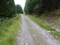 In the Inverlair Forest
 -
 Drake's Bothy in Inshriach Forest


Outside links
- Location map: 56°58’7"N, 4°24’43"W
- East Highland Way
- The East Highland Way on Gemini Walks
- Walk Highlands: The East Highland Way
- Outdoor Capital: Endurance Walks
- East Highland Way on luath.co.uk
- Everytrail: The East Highland Way
- Long Distance Walkers' Association: The East Highland Way
- Northwest Walks: The East Highland Way
- Scottish Natural Heritage
- Cairngorm Wildlife: Wildlife Diary
References
- ↑ "East Highland Way". Walking Scotland. http://walking.visitscotland.com/walks/cairngorms/east-highland-way. Retrieved 2011-10-18.
- ↑ http://www.walkhighlands.co.uk/fortwilliam/fort-william-spean-bridge.shtml
- ↑ Walk Highlands: Spean Bridge to Inverlair
- ↑ East Highland Way, Fergour
- ↑ Walsk Highlands: Inverlair to Pattack
- ↑ Walk Highlands: Pattack
- ↑ Forest Walks – Laggan.com
- ↑ Walk Highlands: Pattach to Laggan
- ↑ Walk Highlands: Laggan to Newtonmore
- ↑ Badenoch Way
- ↑ Walk Highlands: Newtonmore to Kincraig
- ↑ Walk Highlands: Kincraig to Aviemore
- ↑ Cairgorms conservation projects
- Kevin Langan: The East Highland Way