Glimps Holm: Difference between revisions
Created page with "{{Infobox island |name=Glims Holm |norse=Glums Holm |island group=Scapa Flow |county=Orkney |picture= |picture caption= |map=Glims Holm Orkney.svg |map caption=Glims Holm (red..." |
No edit summary |
||
| (One intermediate revision by the same user not shown) | |||
| Line 1: | Line 1: | ||
{{Infobox island | {{Infobox island | ||
|name= | |name=Glimps Holm | ||
|norse=Glums Holm | |norse=Glums Holm | ||
|island group=Scapa Flow | |island group=Scapa Flow | ||
| Line 7: | Line 7: | ||
|picture caption= | |picture caption= | ||
|map=Glims Holm Orkney.svg | |map=Glims Holm Orkney.svg | ||
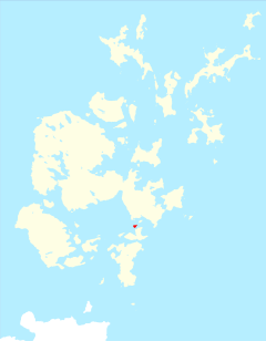
|map caption= | |map caption=Glimps Holm (red) within Orkney | ||
|os grid ref=ND472991 | |os grid ref=ND472991 | ||
|latitude=58.88 | |latitude=58.88 | ||
|longitude=-2.91 | |longitude=-2.91 | ||
|area=55 acres | |area=55 acres | ||
|highest height= | |highest height=105 ft | ||
|population=Uninhabited | |population=Uninhabited | ||
}} | }} | ||
''' | '''Glimps Holm''' is a small uninhabited islet in [[Orkney]], made landfast to each of its neighbours by the [[Churchill Barriers]]. It forms part of the parish of [[South Ronaldsay]]. | ||
The island lies in Holm Sound, one of the eastern entrances to [[Scapa Flow]], between [[Mainland, Orkney|Mainland]] and the island of [[Burray]]. The Churchill Barriers, linking, [[South Ronaldsay]] to Mainland, run down the | The island lies in Holm Sound, one of the eastern entrances to [[Scapa Flow]], between [[Mainland, Orkney|Mainland]] and the island of [[Burray]]. The Churchill Barriers, linking, [[South Ronaldsay]] to Mainland, run down the chain of islands here: Glimps Holm is connected north-eastward to [[Lamb Holm]] (in the parish of [[Holm]]) by Barrier number 2, and to [[Burray]] by Barrier number 3. | ||
The isle was known in Old Norse as ''Glums Holm''<ref>{{Orkneyinga}}</ref>. | The isle was known in Old Norse as ''Glums Holm''<ref>{{Orkneyinga}}</ref>. | ||
Latest revision as of 15:33, 2 November 2020
| Glimps Holm | |
| Location | |
| Location: | 58°52’48"N, 2°54’36"W |
| Grid reference: | ND472991 |
| Area: | 55 acres |
| Highest point: | 105 ft |
| Data | |
| Population: | Uninhabited |
Glimps Holm is a small uninhabited islet in Orkney, made landfast to each of its neighbours by the Churchill Barriers. It forms part of the parish of South Ronaldsay.
The island lies in Holm Sound, one of the eastern entrances to Scapa Flow, between Mainland and the island of Burray. The Churchill Barriers, linking, South Ronaldsay to Mainland, run down the chain of islands here: Glimps Holm is connected north-eastward to Lamb Holm (in the parish of Holm) by Barrier number 2, and to Burray by Barrier number 3.
The isle was known in Old Norse as Glums Holm[1].
History
During the Second World War the Admiralty were concerned to protect their great anchorage in Scapa Flow; the water had many entrances, making it difficult to protect from U-boat attack. Blockships had been sunk to close the narrow passages, but these proved inadequate. The Churchill Barriers were built during Second World War to block the eastern entrances.[2] Much of the labour for the causeways was provided by over 1,300 Italian prisoners of war, captured in North Africa and stationed in Camp 60 on Lamb Holm and two camps on Burray.[3]
| ("Wikimedia Commons" has material about Glimps Holm) |
References
- ↑ Anderson, Joseph (ed.) (1873) The Orkneyinga Saga. Translated by Jón A. Hjaltalin & Gilbert Goudie. Edinburgh. Edmonston and Douglas. The Internet Archive. Retrieved 26 August 2013.
- ↑ Konstam, Angus (2009). Scapa Flow: The Defences of Britain's Great Fleet Anchorage 1914-45. Fortress Series. 85. Osprey Publishing. ISBN 9781846033667.
- ↑ Lamb Holm - Gazetteer for Scotland
| Islands of Orkney |
|---|
|
Inhabited islands: |

