Barkston Ash Wapentake: Difference between revisions
No edit summary |
mNo edit summary |
||
| Line 11: | Line 11: | ||
*[[Church Fenton]] | *[[Church Fenton]] | ||
*[[Drax]] | *[[Drax]] | ||
*[[ | *[[Kirkby Wharfe]] | ||
*[[Ledsham]] | *[[Ledsham]] | ||
*[[Monk Fryston]] | *[[Monk Fryston]] | ||
Latest revision as of 10:43, 6 March 2020

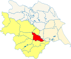
Barkston Ash is a wapentake in the West Riding of Yorkshire, adjacent to the border with the East Riding. It is bounded by the Ainsty to the north; by Claro to the north-west; by Skyrack to the west; by Osgoldcross to the south; and by Howdenshire and Ouse and Derwent in the East Riding to the east. It is named after the meeting-place at the village of Barkston. It had a population of 67,225 in 2011.
The wapentake includes the ancient parishes of:
- Birkin
- Bramham
- Brayton
- Brotherton
- Cawood
- Church Fenton
- Drax
- Kirkby Wharfe
- Ledsham
- Monk Fryston
- Newton Kyme
- Ryther
- Saxton
- Selby
- Sherburn in Elmet
- Snaith (Carlton township)*
- Tadcaster (Tadcaster West, Hazelwood and Sutton)†
- Wistow
*: Remainder in Osgoldcross.
†: Remainder in the Ainsty.
|
East Riding: Buckrose • Dickering • Harthill • Holderness • Howdenshire • Ouse and Derwent • North Riding: Allertonshire • Birdforth • Bulmer • East Gilling • Hallikeld • Hang East • Hang West • Langbaurgh • Pickering Lythe • Ryedale • West Gilling • Whitby Strand • West Riding: Agbrigg and Morley (Agbrigg, Morley) • Ainsty • Barkston Ash • Claro • Osgoldcross • Skyrack • Staincliffe and Ewcross (Staincliffe, Ewcross) • Staincross • Strafforth and Tickhill |
