South Downs

.jpg)
The South Downs are a range of chalk hills that extends for about 260 square miles across the south-eastern coastal counties of Britain from the Itchen Valley of Hampshire in the west to Beachy Head, near Eastbourne in Sussex in the east. It is bounded on its northern side by a steep escarpment, from whose crest there are extensive views northwards across the Weald. The South Downs National Park forms a much larger area than the chalk range of the South Downs and includes large parts of the Weald.
The South Downs is characterised by rolling chalk downland with close-cropped turf and dry valleys, and is recognised as one of the most important chalk landscapes in England.[1] It is one of the four main areas of chalk downland in southern Britain.[2]
The highest point here is Butser Hill, reaching a height of 889 feet above sea level.
The South Downs are one of a pair with the North Downs, running parallel to them to the north. As the North Downs have a scarp slope on the south, so the South Downs' scarp faces northwards: each is one half of the edge of the anciently worn-day Wealden Dome.
Grazing and habitation
The South Downs are relatively unpopulated, for although Sussex there has had large-scale urban encroachment onto the chalk downland by major seaside resorts, including most notably Brighton and neighbouring towns.
The South Downs has been inhabited since ancient times and at periods the area has supported a large population, particularly during Romano-British times. There is a rich heritage of historical features and archaeological remains, including defensive sites, burial mounds and field boundaries. Within the South Downs Environmentally Sensitive Area there are thirty-seven Sites of Special Scientific Interest, including large areas of chalk grassland.[3]
The grazing of sheep on the thin, well-drained chalk soils of the Downs over many centuries and browsing by rabbits resulted in the fine, short, springy turf, known as old chalk grassland, that has come to epitomise the South Downs today. Until the middle of the 20th century, an agricultural system operated by downland farmers known as 'sheep-and-corn farming' underpinned this: the sheep (most famously the Southdown breed) of villagers would be systematically confined to certain corn fields to improve their fertility with their droppings and then they would be let out onto the downland to graze. However, starting in 1940 with government measures during Second World War to increase domestic food output and continuing into the 1950s, much grassland was ploughed up for arable farming, fundamentally changing the landscape and ecology, with the loss of much biodiversity. As a result, while old chalk grassland accounted for 40-50% of the eastern Downs before the war, only 3-4% survives.[4] This and development pressures from the surrounding population centres ultimately led to the decision to create the South Downs National Park, which came into full operation on 1 April 2011.
The downland is an extremely popular recreational destination, particularly for walkers, horseriders and mountain bikers. A long distance footpath and bridleway, the South Downs Way, follows the entire length of the chalk ridge from Winchester to Eastbourne, complemented by many interconnecting public footpaths and bridleways.

Geology


The South Downs are formed from a thick band of chalk which was deposited during the Cretaceous Period around sixty million years ago within a shallow sea which extended across much of northwest Europe and Britain. The chalk is formed of the microscopic skeletons of plankton. The chalk has many fossils, and bands of flint occur throughout the formation.[5] The Chalk is divided into the Lower, Middle and Upper Chalk, a thin band of cream-coloured nodular chalk known as the Melbourn Rock marking the boundary between the Lower and Middle units.
The strata of southeast England, including the Chalk, were gently folded during a phase of the Alpine Orogeny to produce the Weald-Artois Anticline, a dome-like structure with a long east-west axis. Erosion has removed the central part of the dome, leaving the north-facing escarpment of the South Downs along its southern margin with the south-facing chalk escarpment of the North Downs as its counterpart on the northern side.
Between these two escarpments the anticline has been subject to differential erosion so that geologically distinct areas of hills and vales lie in roughly concentric circles towards the centre; these comprise the Greensand Ridge, most prominent on the north side of the Weald, where it includes Leith Hill, the highest hill in Surrey and in all of south-eastern Britain, the low-lying clay vales of the Low Weald, formed of less resistant Weald Clay, and finally the more highly resistant sandstones of the High Weald at the centre of the anticline, whose elevated forest ridge includes most notably Ashdown Forest.[6]
The chalk is porous, and allows water to soak through; as a result there are many winterbournes along the northern edge.
Geography
The South Downs is a long chalk escarpment that stretches for over 70 miles, rising from the valley of the River Itchen near Winchester, Hampshire, in the west to Beachy Head near Eastbourne in Sussex, in the east.[7] Behind the steep north-facing scarp slope, the gently inclined dip slope of undulating chalk downland extends for a distance of up to 7 miles southwards. Viewed from high points further north in the High Weald and on the North Downs, the scarp of the South Downs presents itself as a steep wall that bounds the horizon, with its grassland heights punctuated with clumps of trees (such as Chanctonbury Ring).
In the west, the chalk ridge of the South Downs merges with the North Downs to form the Hampshire Downs. In the east, the escarpment terminates at the English Channel coast between Seaford and Eastbourne, where it produces the spectacular white cliffs of Seaford Head, the Seven Sisters, whose undulations reveal a cross-section through a pre-existing landscape of parallel ridges and dry valleys that has been exposed as the high chalk headland has receded through erosion by the sea, and Beachy Head, the highest chalk sea cliff in Britain at 531 feet above sea level.
The South Downs may be said to have three main component parts: the East Hampshire Downs, the Western Downs and the Eastern Downs, together with the river valleys that cut across them and the land immediately below them, the scarpfoot. The Western and Eastern Downs are often collectively referred to as the Sussex Downs. The Western Downs, lying west of the River Arun, are much more wooded, particularly on the scarp face, than the Eastern Downs. It is the bare Eastern Downs - the only part of the chalk escarpment to which, until the late 19th century, the term "South Downs" was usually applied - that has come to epitomise, in literature and art, the South Downs as a whole and which has been the subject matter of such celebrated writers and artists as Rudyard Kipling (the "blunt, bow-headed, whale-backed downs") and Eric Ravilious.
Four river valleys cut through the South Downs, namely those of the rivers Arun, Adur, Ouse and Cuckmere, providing a contrasting landscape. Chalk aquifers and to a lesser extent brroks formed as winterbournes supply much of the water required by the surrounding settlements. Dew ponds, artificial ponds for watering livestock, are a characteristic feature on the downland.
The highest point on the South Downs is Butser Hill, whose summit is 886 feet above sea level. The plateau-like top of this vast, irregularly shaped hill, which lies just south of Petersfield, Hampshire, was in regular use through prehistory. It has been designated as a "National Nature Reserve".
A list of those hill tops on the South Downs above 700 feet, going from west to east, is given below.
| Name of hill | Nearest village | Height | Notes |
|---|---|---|---|
| Butser Hill | Petersfield | 886 feet | Highest point in the South Downs |
| West Harting Down | South Harting | 707 feet | |
| Beacon Hill | South Harting | 793 feet | |
| Linch Down | Bepton | 814 feet | |
| Littleton Down | East Lavington | 836 feet | The summit, Crown Teglease, is the highest point on the Sussex Downs. |
| Glatting Beacon | Sutton | 803 feet | |
| Chanctonbury Hill | Washington | 782 feet | Site of Chanctonbury Ring hill fort |
| Truleigh Hill | Upper Beeding | 708 feet | |
| Ditchling Beacon | Ditchling | 814 feet | |
| Firle Beacon | Firle | 713 feet |
Historical interest

Archaeological evidence has revealed that the Downs have been inhabited for thousands of years. Neolithic flint mines such as Cissbury, burial mounds such as the Devil's Jumps and Devil's Humps, and hill forts like Chanctonbury Ring are strong features in the landscape.[8][9]
It has been estimated that the tree cover of the downs was cleared over 3,000 years ago, and the present closely grazed turf is the result of continual grazing by sheep.
Conservation
National park
Proposals to create a national park for the South Downs date back to the 1940s. However, it was not until 1999 that the idea received firm government support. After a public enquiry that took place between 2003 and 2009, the government announced its decision to make the South Downs a national park on 31 March 2009. The South Downs National Park finally came into operation on 1 April 2011. Within its boundary are included not only the South Downs proper but also part of the western Weald, a geologically and ecologically quite different district.
National Nature Reserves
The South Downs contains a number of "National Nature Reserves":[10]
- Sussex:
- Kingley Vale, near Chichester, ("contain one of the finest yew forests in Europe, including a grove of ancient trees which are among the oldest living things in Britain")
- Castle Hill, between Brighton and Lewes ("an important example of ancient, traditionally managed grassland"
- Lewes Downs (Mount Caburn) ("a traditionally managed chalk downland" (and an important archaeological site)
- Lullington Heath, north-west of Eastbourne, one the largest areas of chalk heath in Britain.
- Hampshire:
- Butser Hill, near Petersfield, a large area of chalk grassland on the highest point in the South Downs (a large area is also designated as a Scheduled Ancient Monument reflecting its historical significance, particularly in the Bronze and Iron Ages)
- Old Winchester Hill, a lowland grassland on the west and south facing scarp slopes of the Meon valley
- Beacon Hill, a high quality chalk grassland 3 miles west of Old Winchester Hill.
Tourism, leisure and sport
In 1923 the Society of Sussex Downsmen (now the South Downs Society) was formed with the aim of protecting the area's unique landscape.[11]
The South Downs is a popular area for ramblers with a network of over 2,000 miles of well-managed, well-signed and easily accessible trails. The principal bridleway, and longest of them, is the South Downs Way.[12] The Monarch's Way, having originated at Worcester, crosses the South Downs and ends at Shoreham-by-Sea.[13]
Sports undertaken on the Downs include paragliding, mountain-biking, horse riding and walking.[14] The popular Beachy Head Marathon (formerly Seven Sisters Marathon), a hilly cross-country marathon, takes place each autumn on the eastern Downs, starting and finishing in Eastbourne.
Sights on the hills

Two of the landmarks on the Downs are the Long Man of Wilmington, a chalk carved figure, and Clayton Windmills. There is also a war memorial, The Chattri, dedicated to Indian soldiers who died in the Brighton area, having been brought there for treatment after being injured fighting on the Western Front in the First World War.
South Downs in literature
Rudyard Kipling who lived at Rottingdean described the South Downs as "Our blunt, bow-headed whale-backed Downs".[15]
Kipling celebrated the South Downs in two children's books, Puck of Pook's Hill and Rewards and Fairies, in which Pook introduces the children of the books to the shades of past days in the Downs, each of whom tells a tale out of Sussex folklore and great themes of British history, as seen from a Sussex perspective.
Writing in 1920 in his poem The South Country, poet Hilaire Belloc describes the South Downs as "the great hills of the South Country".[16] In On The South Coast, poet Algernon Charles Swinburne describes the South Downs as "the green smooth-swelling unending downs".[17]
The naturalist-writer William Henry Hudson wrote that "during the whole fifty-three mile length from Beachy Head to Harting the ground never rises above a height of 850 feet, but we feel on top of the world".[18]
Poet Francis William Bourdillon also wrote a poem "On the South Downs".[19] The South Downs have been home to several writers including Jane Austen who lived at Chawton on the edge of the Downs in Hampshire. The Bloomsbury Group often visited Monk's House in Rodmell, the home of Virginia Woolf in the Ouse valley. Alfred, Lord Tennyson had a second home at Aldworth, on Blackdown; geologically part of the Weald, Blackdown lies north of the South Downs but is included in the South Downs National Park.
Pictures
-
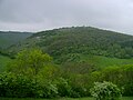 Part of the Downs near Devil's Dyke, Sussex
 -
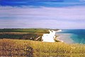 South Downs close to Beachy Head


Outside links
References
- ↑ Source: Natural England, South Downs ESA.
- ↑ The others being the North Downs of Kent and Surrey; the Chilterns in Oxfordshire-Buckinghamshire-Hertfordshire-Bedfordshire; and the North Wessex Downs of Wiltshire-Dorset-Hampshire-Berkshire.
- ↑ Source: Natural England.
- ↑ Peter Brandon, The South Downs (Halsgrove, Tiverton, 2003), p.51.
- ↑ Shepherd, Roy, Chalk formation fossils, Discovering fossils, http://www.discoveringfossils.co.uk/chalk_formation_fossils.htm, retrieved 5 April 2011.
- ↑ British Geological Survey 1:50K map sheet 318/333 Brighton & Worthing.
- ↑ Severla definitions are touted as to where in the west the South Downs really begin: for Brandon (1998), the South Downs begin east of the valley of the River Meon, with Old Winchester Hill marking the beginning of the chalk ridge.
- ↑ "South Downs". English Heritage. http://www.english-heritage.org.uk/server/show/nav.001002003005001006. Retrieved 5 April 2011..
- ↑ South Downs Way, nationaltrail.co.uk, http://www.nationaltrail.co.uk/southdowns/text.asp?PageId=30, retrieved 5 April 2011.
- ↑ Natural England - NNRs
- ↑ South Downs Society website, http://www.southdownssociety.org.uk/index.html, retrieved 5 April 2011.
- ↑ South Downs Way: description of the route.
- ↑ South Downs Way National Trail, Ramblers Association, http://www.ramblers.org.uk/info/paths/southdowns.html, retrieved 5 April 2011.
- ↑ Outdoor activities, South Downs National Park Authority, http://www.southdowns.gov.uk/enjoying/outdoor-activities/, retrieved 5 April 2011.
- ↑ Kipling, Rudyard (1907), Collected Verse of Rudyard Kipling, New York: Doubleday, Page and Co., p. 123.
- ↑ Walters, L. D'O., ed. (1920), An anthology of recent poetry, New York: Dodd and Mead, p. 9, http://www.archive.org/stream/anthologyofrecen00walt#page/9/mode/1up.
- ↑ Swinburne, Algernon Charles (1911), Poems of Algernon Charles Swinburne. Volume VI, London: Chatto and Windus, p. 147, http://www.archive.org/stream/poemsofalgernonc06swiniala#page/147/mode/1up.
- ↑ McCarthy, Michael (10 November 2003), "The wild, serene Downs fight against protection", The Independent (London), http://www.independent.co.uk/environment/the-wild-serene-downs-fight-against-protection-735190.html.
- ↑ Francis William Bourdillon: On the South Downs, Poem Hunter, http://www.poemhunter.com/poem/on-the-south-downs/, retrieved 5 April 2011.
Books
- Hudson, W.H. (1901), Nature in Downland, London: Longmans and Green, http://www.archive.org/stream/cu31924022545093#page/n15/mode/2up.