Lonsdale Hundred: Difference between revisions
No edit summary |
No edit summary |
||
| Line 16: | Line 16: | ||
*[[Morecambe]] | *[[Morecambe]] | ||
*[[Ulverston]] | *[[Ulverston]] | ||
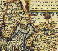
[[File:Hundred of Lonsdale.png|thumb|200px|The Hundred of Lonsdale as shown on John Speed's 1610 map of Lancashire]] | |||
==Parishes== | |||
Lonsdale Hundred comprises the ancient parishes of: | |||
;North Lonsdale: | |||
{{div col|3}} | |||
*[[Aldingham]] | |||
*[[Angerton]] | |||
*[[Cartmel]] | |||
*[[Colton]] | |||
*[[Dalton in Furness]] | |||
*[[Holme Island]] (ex. par.) | |||
*[[Kirkby Ireleth]] | |||
*[[Pennington]] | |||
*[[Ulverston]] | |||
*[[Urswick]] | |||
*[[Hawkshead]] | |||
{{div col end}} | |||
;South Lonsdale: | |||
{{div col|3}} | |||
*[[Bolton-le-Sands]] | |||
*[[Burton-in-Kendal]] (Dalton township)<sup>*</sup> | |||
*[[Claughton]] | |||
*[[Cockerham]] | |||
*Cockersand (ex. par.) | |||
*[[Halton]] | |||
*[[Heysham]] | |||
*[[Lancaster]] (part)<sup>†</sup> | |||
*[[Melling]] | |||
*[[Tatham]] | |||
*[[Thornton in Lonsdale]] ([[Ireby, Lancashire|Ireby]] township)<sup>‡</sup> | |||
*[[Tunstall, Lancashire|Tunstall]] | |||
*[[Warton]] | |||
*[[Whittington, Lancashire|Whittington]] | |||
{{div col end}} | |||
<sup>*</sup>: Remainder in Westmorland.<br /> | |||
<sup>†</sup>: Detached part of Lancaster, comprising Preesall with Hackensall, and Stalmine with Staynall in Amounderness.<br /> | |||
<sup>‡</sup>: Remainder in Yorkshire. | |||
==Outside links== | ==Outside links== | ||
*[http://www.lancashire.gov.uk/environment/oldmap/others/hundreds.jpg Map of the Lancashire Hundreds] | *[http://www.lancashire.gov.uk/environment/oldmap/others/hundreds.jpg Map of the Lancashire Hundreds] | ||
{{Hundreds of Lancashire}} | {{Hundreds of Lancashire}} | ||
Revision as of 15:55, 27 November 2019

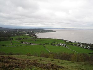
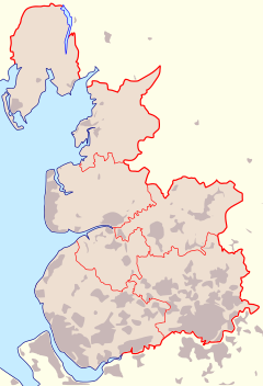
The Lonsdale Hundred is a hundred of Lancashire, covering most of the north-western part of Lancashire around Morecambe Bay. It is in two parts; the vicinity of Lancaster attached to the main body of the county, and the whole of Lancashire North of the Sands, which is the detached part of the county on the north coast of Morecambe Bay including Furness. Lancashire North of the Sands is some time called "North Lonsdale" for this reason. The population of the hundred numbered 240,202 in 2011, which ranks it fifth out of the six hundreds.
The name Lonsdale is taken from the dale of that name, Lonsdale being the valley of the River Lune in Lancashire and Westmorland.
The hundred is tied together by Morecambe Bay, whose coast defines it. There is a variety of landscape inland however, from the high Furness Fells north of the sands, to the low coastal plains in south Lonsdale, but rising too into the Pennines.
Towns and places
Places in the Lonsdale Hundred include:

Parishes
Lonsdale Hundred comprises the ancient parishes of:
- North Lonsdale
- South Lonsdale
- Bolton-le-Sands
- Burton-in-Kendal (Dalton township)*
- Claughton
- Cockerham
- Cockersand (ex. par.)
- Halton
- Heysham
- Lancaster (part)†
- Melling
- Tatham
- Thornton in Lonsdale (Ireby township)‡
- Tunstall
- Warton
- Whittington
*: Remainder in Westmorland.
†: Detached part of Lancaster, comprising Preesall with Hackensall, and Stalmine with Staynall in Amounderness.
‡: Remainder in Yorkshire.
Outside links
|
Amounderness • Blackburnshire • Leyland • Lonsdale • Salfordshire • West Derby |

