Wallington Hundred: Difference between revisions
No edit summary |
No edit summary |
||
| (One intermediate revision by the same user not shown) | |||
| Line 1: | Line 1: | ||
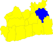
[[File:Wallington Hundred - Surrey.svg|right|thumb|220px|The Hundred of Wallington in Surrey]] | [[File:Wallington Hundred - Surrey.svg|right|thumb|220px|The Hundred of Wallington in Surrey]] | ||
'''Wallington''' is a hundred of [[Surrey]], in the north-east of the county. The majority of its area is now within the metropolitan conurbation. | '''Wallington''' is a hundred of [[Surrey]], in the north-east of the county. The majority of its area is now within the metropolitan conurbation. It is the second-most populous of the hundreds after [[Brixton Hundred|Brixton]], with a population of 656,760 in 2011. | ||
The hundred contains the ancient parishes of [[Addington, Surrey|Addington]] | The hundred contains the ancient parishes of:<ref name=British>{{brithist|43046|The hundred of Wallington}}</ref> | ||
{{div col|3}} | |||
*[[Addington, Surrey|Addington]] | |||
*[[Beddington]] | |||
*[[Carshalton]] | |||
*[[Chaldon]] | |||
*[[Cheam]] | |||
*[[Coulsdon]] | |||
*[[Croydon]] | |||
*[[Mitcham]] | |||
*[[Morden]] | |||
*[[Sanderstead]] | |||
*[[Sutton, Surrey|Sutton]] | |||
*[[Woodmansterne]] | |||
{{div col end}} | |||
In Surrey it is bounded by the hundreds of [[Brixton Hundred|Brixton]] to the north, [[Kingston Hundred|Kingston]] and [[Copthorne Hundred|Copthorne]] to the west, [[Reigate Hundred|Reigate]] and [[Tandridge Hundred|Tandridge]] to the south. In the east its boundary is with the [[Bromley and Beckenham Hundred]] of [[Kent]]. | In Surrey it is bounded by the hundreds of [[Brixton Hundred|Brixton]] to the north, [[Kingston Hundred|Kingston]] and [[Copthorne Hundred|Copthorne]] to the west, [[Reigate Hundred|Reigate]] and [[Tandridge Hundred|Tandridge]] to the south. In the east its boundary is with the [[Bromley and Beckenham Hundred|Bromley and Beckenham]] and [[Ruxley Hundred]]s of [[Kent]]. | ||
In 1831, the hundred was measured as of 36,470 acres in area.<ref>[http://www.visionofbritain.org.uk/data_cube_table_page.jsp?data_theme=T_POP&data_cube=N_AREA_A&u_id=10140936&c_id=10001043&add=Y Vision of Britain] - Wallington hundred - area ([http://www.visionofbritain.org.uk/bound_map_page.jsp?first=true&u_id=10140936&c_id=10001043 historic map])</ref> | In 1831, the hundred was measured as of 36,470 acres in area.<ref>[http://www.visionofbritain.org.uk/data_cube_table_page.jsp?data_theme=T_POP&data_cube=N_AREA_A&u_id=10140936&c_id=10001043&add=Y Vision of Britain] - Wallington hundred - area ([http://www.visionofbritain.org.uk/bound_map_page.jsp?first=true&u_id=10140936&c_id=10001043 historic map])</ref> | ||
| Line 12: | Line 26: | ||
{{Surrey hundreds}} | {{Surrey hundreds}} | ||
[[Category:Metropolitan Surrey]] | |||
Latest revision as of 14:53, 30 December 2018

Wallington is a hundred of Surrey, in the north-east of the county. The majority of its area is now within the metropolitan conurbation. It is the second-most populous of the hundreds after Brixton, with a population of 656,760 in 2011.
The hundred contains the ancient parishes of:[1]
In Surrey it is bounded by the hundreds of Brixton to the north, Kingston and Copthorne to the west, Reigate and Tandridge to the south. In the east its boundary is with the Bromley and Beckenham and Ruxley Hundreds of Kent.
In 1831, the hundred was measured as of 36,470 acres in area.[2]
References
- ↑ The hundred of Wallington
- ↑ Vision of Britain - Wallington hundred - area (historic map)
| Hundreds of Surrey |
|---|
|
Blackheath • Brixton • Copthorne • Effingham (half) • Elmbridge • Farnham • Godalming • Godley • Kingston • Reigate • Tandridge • Wallington • Woking • Wotton |