Woodmansterne
| Woodmansterne | |
| Surrey | |
|---|---|
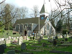
 St Peter's Church, Woodmansterne | |
| Location | |
| Grid reference: | TQ272599 |
| Location: | 51°19’27"N, 0°10’33"W |
| Data | |
| Population: | 2,979 (2011) |
| Post town: | Banstead / Coulsdon |
| Postcode: | SM7 / CR5 |
| Dialling code: | 020 |
| Local Government | |
| Council: | Reigate and Banstead |
| Parliamentary constituency: |
Reigate |
Woodmansterne is a village towards the east of Surrey, close by the edge of the swollen Metropolitan conurbation. The village stands on a small plateau of and a southern down slope of the North Downs and its ecclesiastical parish reaches into Chipstead, Coulsdon and Wallington. It is within Surrey's Wallington Hundred.
Woodmansterne railway station is on Chipstead Valley Road.
History
The village appears in Domesday Book of 1086 as Odemerestor, apparently derived from the Old English Wudumere torr, for 'wood pond high ground'. It was held by Richard de Tonebrige. Its Domesday assets were: 15 hides; 1 church, 1 mill worth 20s, 5 ploughs, four acres of meadow, wood worth 10 hogs. It rendered £8 per year to its lord.
Parish church
The parish church, St Peter's Church, is a Victorian replacement of an older building and due to its late Victorian date and not being by an architect of national renown (as at 2013) it is not a listed building.
The church was built in 1877, to a tall and steeply hipped-gable roof design by Mr J. Clarke.
About the village
Weston Acres is a house at the west of the village, standing within a smallholding. It is a Grade II listed building. Built as a large house it later became accommodation for Seafarers UK (at the time: the Seafarer's Society). Mostly built in 1906, the north entrance front was added in 1915, designed by architect Sydney Tatchell. The design was exhibited at the Royal Academy exhibition in 1916 and was published in several building magazines of the period.
Woodmansterne is a residential linear settlement on two main roads, with a few side estates, green-buffered in every direction bar two compass points by woods, allotments, and two small farms. The two contiguous settlements it adjoins are in the south, Chipstead, and in the east, a suburban part of the town of Coulsdon. Most of the village sits on a long, gentle down slope to the south; a middle part of the Chipstead Bottom Valley. The large gentle slope is half of the major crevice into the widest part of the North Downs.
Outside links
| ("Wikimedia Commons" has material about Woodmansterne) |