River Ribble: Difference between revisions
| (5 intermediate revisions by 3 users not shown) | |||
| Line 1: | Line 1: | ||
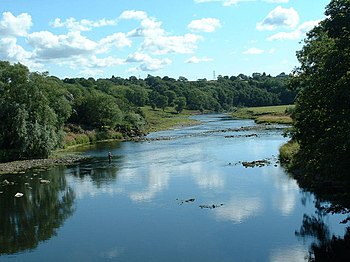
[[File:Ribble - geograph.org.uk - 42616.jpg|right|thumb|350px|The Ribble at Ribchester]] | [[File:Ribble - geograph.org.uk - 42616.jpg|right|thumb|350px|The Ribble at Ribchester]] | ||
The '''River Ribble''' is a river 75 miles long which runs through the [[West Riding of Yorkshire]] and [[Lancashire]], reaching the sea in a long, funnel-shaped estuary below [[Preston]]. | The '''River Ribble''' is a river 75 miles long which runs through the [[West Riding of Yorkshire]] and [[Lancashire]], reaching the sea in a long, funnel-shaped estuary below [[Preston]]. At [[Clitheroe]] it forms the border between the two counties. | ||
==Geography== | ==Geography== | ||
[[File:Ribblehead Viaduct in North Yorkshire.jpg|right|thumb|250px|The Ribblehead Viaduct]] | [[File:Ribblehead Viaduct in North Yorkshire.jpg|right|thumb|250px|The Ribblehead Viaduct]] | ||
The Ribble begins at the meeting of the Gayle Beck and Cam Beck near the famous Ribblehead | The Ribble begins at the meeting of the Gayle Beck and Cam Beck near the famous [[Ribblehead Viaduct]] at [[Ribblehead]], in the shadow of the Yorkshire three peaks. | ||
The river flows through [[Settle]], [[Clitheroe]], [[Ribchester]] and [[Preston]], before emptying into the [[Irish Sea]] between [[Lytham St Annes]] and [[Southport]]; a length of 75 miles. | The river flows through [[Settle]], [[Clitheroe]], [[Ribchester]] and [[Preston]], before emptying into the [[Irish Sea]] between [[Lytham St Annes]] and [[Southport]]; a length of 75 miles. | ||
| Line 10: | Line 10: | ||
The main tributaries of the Ribble are the [[River Hodder|Hodder]] and [[River Calder, Lancashire|Calder]] which join the river near Great Mitton, the [[River Darwen]] which joins at [[Walton-le-Dale]] and the [[River Douglas, Lancashire|River Douglas]] which joins near [[Hesketh Bank]]. | The main tributaries of the Ribble are the [[River Hodder|Hodder]] and [[River Calder, Lancashire|Calder]] which join the river near Great Mitton, the [[River Darwen]] which joins at [[Walton-le-Dale]] and the [[River Douglas, Lancashire|River Douglas]] which joins near [[Hesketh Bank]]. | ||
The Ribble Way is a long-distance footpath which follows the river for much of its course. At the time of the [[Domesday Book]], the river formed the northern boundary of an area of land listed separately as ''Inter Ripam et Mersam'' attached to the material for [[Cheshire]], though it was probably not formally part of the county of | The [[Ribble Way]] is a long-distance footpath which follows the river for much of its course. At the time of the [[Domesday Book]], the river formed the northern boundary of an area of land listed separately as ''Inter Ripam et Mersam'' attached to the material for [[Cheshire]], though it was probably not formally part of the county of Chester.<ref>Harris and Thacker (1987). write on page 252: {{quotation|Certainly there were links between Cheshire and south Lancashire before 1000, when Wulfric Spot held lands in both territories. Wulfric's estates remained grouped together after his death, when they were left to his brother Aelfhelm, and indeed there still seems to have been some kind of connexion in 1086, when south Lancashire was surveyed together with Cheshire by the Domesday commissioners. Nevertheless, the two territories do seem to have been distinguished from one another in some way and it is not certain that the shire-moot and the reeves referred to in the south Lancashire section of Domesday were the Cheshire ones.}}</ref><ref>Phillips and Phillips (2002). pp. 26–31.</ref><ref>Crosby, A. (1996). writes on page 31: {{quotation|The Domesday Survey (1086) included south Lancashire with Cheshire for convenience, but the Mersey, the name of which means 'boundary river' is known to have divided the kingdoms of [[Northumbria]] and [[Mercia]] and there is no doubt that this was the real boundary.}}</ref> | ||
The river is connected to both the [[Leeds and Liverpool Canal]] and the [[Lancaster Canal]] (by the [[Ribble Link]]). The river downstream of Preston was actively dredged when Preston was an active port; this is no longer done and silt from the river is now spreading more widely over the (sand) beaches around [[Lytham|Fairhaven]] and [[St Annes]]. | The river is connected to both the [[Leeds and Liverpool Canal]] and the [[Lancaster Canal]] (by the [[Ribble Link]]). The river downstream of Preston was actively dredged when Preston was an active port; this is no longer done and silt from the river is now spreading more widely over the (sand) beaches around [[Lytham|Fairhaven]] and [[St Annes]]. | ||
| Line 29: | Line 29: | ||
The banks of the Ribble have been posited as a possible location for King Arthur's tenth battle, on the banks of a river "Tribruit", as alluded to in his Historia Brittonum by Nennius.<ref>[http://www.mun.ca/mst/heroicage/issues/2/ha2lac.htm Malcor, L.A. (1999). ''Lucius Artorius Castus''] Retrieval Date: 26 January 2008.</ref> | The banks of the Ribble have been posited as a possible location for King Arthur's tenth battle, on the banks of a river "Tribruit", as alluded to in his Historia Brittonum by Nennius.<ref>[http://www.mun.ca/mst/heroicage/issues/2/ha2lac.htm Malcor, L.A. (1999). ''Lucius Artorius Castus''] Retrieval Date: 26 January 2008.</ref> | ||
The Cuerdale Hoard was discovered in the | The Cuerdale Hoard was discovered in the nineteenth century buried by the banks of the Ribble. It is the largest hoard of Norse/Danish silver ever found in the [[British Isles]] and is dated to between 903 and 910. The Hoard suggest that the Ribble was a major conduit for trade between Viking [[Dublin]] and [[York]]. The hoard is believed to have been buried at the time that Dublin was lost to the Irish and may have been brought out of Dublin to the Lancashire shore for safekeeping, never to be recovered. | ||
==Towns and villages on the Ribble== | ==Towns and villages on the Ribble== | ||
| Line 37: | Line 37: | ||
===Yorkshire (West Riding)=== | ===Yorkshire (West Riding)=== | ||
*[[Horton in Ribblesdale]] | *[[Horton in Ribblesdale]] | ||
*[[Stainforth]] | *[[Stainforth, Craven|Stainforth]] | ||
*[[Stackhouse]] | *[[Stackhouse]] | ||
*[[Langcliffe]] | *[[Langcliffe]] | ||
| Line 45: | Line 45: | ||
*[[Nappa]] | *[[Nappa]] | ||
*[[Paythorne]] | *[[Paythorne]] | ||
*[[Sawley, | *[[Sawley, Ribble Valley|Sawley]] | ||
*[[West Bradford]] | *[[West Bradford]] | ||
|valign="top"| | |valign="top"| | ||
===Lancashire=== | ===Lancashire=== | ||
*[[Horrocksford]] | *[[Horrocksford]] | ||
| Line 90: | Line 91: | ||
*[http://www.ribbletrust.org.uk/ Ribble Trust] | *[http://www.ribbletrust.org.uk/ Ribble Trust] | ||
[[Category:Rivers of Lancashire]] [[Category:Rivers of Yorkshire]] | [[Category:Rivers of Lancashire|Ribble]] [[Category:Rivers of Yorkshire|Ribble]] | ||
Latest revision as of 13:35, 21 September 2017

The River Ribble is a river 75 miles long which runs through the West Riding of Yorkshire and Lancashire, reaching the sea in a long, funnel-shaped estuary below Preston. At Clitheroe it forms the border between the two counties.
Geography

The Ribble begins at the meeting of the Gayle Beck and Cam Beck near the famous Ribblehead Viaduct at Ribblehead, in the shadow of the Yorkshire three peaks.
The river flows through Settle, Clitheroe, Ribchester and Preston, before emptying into the Irish Sea between Lytham St Annes and Southport; a length of 75 miles.
The main tributaries of the Ribble are the Hodder and Calder which join the river near Great Mitton, the River Darwen which joins at Walton-le-Dale and the River Douglas which joins near Hesketh Bank.
The Ribble Way is a long-distance footpath which follows the river for much of its course. At the time of the Domesday Book, the river formed the northern boundary of an area of land listed separately as Inter Ripam et Mersam attached to the material for Cheshire, though it was probably not formally part of the county of Chester.[1][2][3]
The river is connected to both the Leeds and Liverpool Canal and the Lancaster Canal (by the Ribble Link). The river downstream of Preston was actively dredged when Preston was an active port; this is no longer done and silt from the river is now spreading more widely over the (sand) beaches around Fairhaven and St Annes.
Its estuary forms part of the Ribble and Alt Estuaries Special Protection Area for wildlife.
The Normal Tidal Limit (NTL) of the river is at Fishwick Bottoms, between Preston and Walton-le-Dale.
Public works
The River Ribble catchment is covered by the Mersey Basin Campaign, a partnership which was established in 1985 to improve water quality and encourage waterside regeneration.
Preston City Council have published controversial plans to build a barrage across the River Ribble, in their 'Riverworks' proposals. The aim of these proposals is to build a water sports park on a section of the Ribble, coupled with over 4000 units of high quality housing and businesses in the river's flood plain. Some local residents are opposing these plans, arguing that they endanger wildlife, increase flood risk to local housing and damage greenbelt areas. These residents have set up the 'Save The Ribble' campaign. Parts of the river are a County Biological Heritage Site.
The Ribble would appear to have been known in Roman times as the Belisama,[4] possibly giving its name to Samlesbury. Ptolemy's "Belisama aest." seems to represent the estuary of the Ribble.
Historical interest

The banks of the Ribble have been posited as a possible location for King Arthur's tenth battle, on the banks of a river "Tribruit", as alluded to in his Historia Brittonum by Nennius.[5]
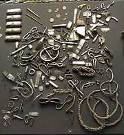
The Cuerdale Hoard was discovered in the nineteenth century buried by the banks of the Ribble. It is the largest hoard of Norse/Danish silver ever found in the British Isles and is dated to between 903 and 910. The Hoard suggest that the Ribble was a major conduit for trade between Viking Dublin and York. The hoard is believed to have been buried at the time that Dublin was lost to the Irish and may have been brought out of Dublin to the Lancashire shore for safekeeping, never to be recovered.
Towns and villages on the Ribble
Yorkshire (West Riding) |
Lancashire |
Main Tributaries

The main tributaries of the Ribble are:
- River Douglas or River Asland
- Savick Brook
- River Darwen
- Stydd Brook
- Dinckley Brook
- River Calder
- River Hodder
References
- ↑ Harris and Thacker (1987). write on page 252:
Certainly there were links between Cheshire and south Lancashire before 1000, when Wulfric Spot held lands in both territories. Wulfric's estates remained grouped together after his death, when they were left to his brother Aelfhelm, and indeed there still seems to have been some kind of connexion in 1086, when south Lancashire was surveyed together with Cheshire by the Domesday commissioners. Nevertheless, the two territories do seem to have been distinguished from one another in some way and it is not certain that the shire-moot and the reeves referred to in the south Lancashire section of Domesday were the Cheshire ones.
- ↑ Phillips and Phillips (2002). pp. 26–31.
- ↑ Crosby, A. (1996). writes on page 31:
The Domesday Survey (1086) included south Lancashire with Cheshire for convenience, but the Mersey, the name of which means 'boundary river' is known to have divided the kingdoms of Northumbria and Mercia and there is no doubt that this was the real boundary.
- ↑ Hutton, p. 218
- ↑ Malcor, L.A. (1999). Lucius Artorius Castus Retrieval Date: 26 January 2008.
Books
- Crosby, A. (1996). A History of Cheshire. (The Darwen County History Series.) Chichester, West Sussex, UK: Phillimore & Co. Ltd. ISBN 0850339324.
- Harris, B. E., and Thacker, A. T. (1987). The Victoria History of the County of Chester. (Volume 1: Physique, Prehistory, Roman, Anglo-Saxon, and Domesday). Oxford: Oxford University Press. ISBN 0197227619.
- Morgan, P. (1978). Domesday Book Cheshire: Including Lancashire, Cumbria, and North Wales. Chichester, Sussex: Phillimore & Co. Ltd. ISBN 0850331404.
- Phillips A. D. M., and Phillips, C. B. (2002), A New Historical Atlas of Cheshire. Chester, UK: Cheshire County Council and Cheshire Community Council Publications Trust. ISBN 0904532461.
- Greenhalgh, M (2009). Ribble: river and valley, a local and natural history. Lancaster, Carnegie Publishing. ISBN 9781859361351.
Outside links
| ("Wikimedia Commons" has material about Ribble River Ribble) |
