Difference between revisions of "Hyskeir Lighthouse"
(Created page with "{{Infobox lighthouse |name=Hyskeir Lighthouse |county=Argyll |latitude=56.969361 |longitude=-6.680444 |picture=Oigh Sgier - geograph.org.uk - 119673.jpg |picture caption = Hys...") |
|||
| Line 19: | Line 19: | ||
|ARLHS = SCO-106 | |ARLHS = SCO-106 | ||
}} | }} | ||
| − | '''Hyskeir Lighthouse''' was established in 1904. The 128-foot-high lighthouse marks the southern end of [[the Minch]], warning of the presence of the Mills Rocks, [[Canna]] and [[Hyskeir]] itself. It was designed by David and Charles Stevenson and constructed by [[Oban]] contractor Messrs D & J MacDougall. | + | '''Hyskeir Lighthouse''' was established in 1904 on the island of [[Hyskeir]] in [[Argyllshire]]. The 128-foot-high lighthouse marks the southern end of [[the Minch]], warning of the presence of the Mills Rocks, [[Canna]] and [[Hyskeir]] itself. It was designed by David and Charles Stevenson and constructed by [[Oban]] contractor Messrs D & J MacDougall. |
The white tower was manned until March 1997, becoming one of the last lighthouses in Scotland to be automated. The keepers were briefly known for their one-hole golf course<ref name="gaz">{{cite web| url=http://www.scottish-places.info/features/featurefirst1625.html | title=Hyskeir | publisher=Gazetteer for Scotland| accessdate=15 September 2009}}</ref> following their appearance on TV. Now controlled by the [[Northern Lighthouse Board]] in [[Edinburgh]], it displays three white flashes every thirty seconds.<ref>{{cite web| url=http://www.nlb.org.uk/ourlights/history/hyskeir.htm| publisher=Northern Lighthouse Board| title=Hyskeir Lighthouse| accessdate=15 September 2009}}</ref> | The white tower was manned until March 1997, becoming one of the last lighthouses in Scotland to be automated. The keepers were briefly known for their one-hole golf course<ref name="gaz">{{cite web| url=http://www.scottish-places.info/features/featurefirst1625.html | title=Hyskeir | publisher=Gazetteer for Scotland| accessdate=15 September 2009}}</ref> following their appearance on TV. Now controlled by the [[Northern Lighthouse Board]] in [[Edinburgh]], it displays three white flashes every thirty seconds.<ref>{{cite web| url=http://www.nlb.org.uk/ourlights/history/hyskeir.htm| publisher=Northern Lighthouse Board| title=Hyskeir Lighthouse| accessdate=15 September 2009}}</ref> | ||
Latest revision as of 20:27, 2 November 2020
| Hyskeir Lighthouse | |
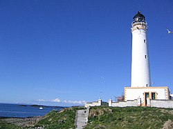
 Hyskeir Light, May 2005 | |
|---|---|
| Location | |
| Location: | 56°58’10"N, 6°40’50"W |
| Characteristics | |
| Height: | 128 ft |
| Tower shape: | cylindrical tower with balcony and lantern attached to 1-storey keeper's house |
| Tower marking: | white tower, black lantern, ochre trim |
| Light: | Fl (3) W 30s. |
| Focal height: | 135 ft |
| Range: | 24 nmi |
| Admiralty No.: | A4076 |
| History | |
| Built 1904 | |
| Information | |
Hyskeir Lighthouse was established in 1904 on the island of Hyskeir in Argyllshire. The 128-foot-high lighthouse marks the southern end of the Minch, warning of the presence of the Mills Rocks, Canna and Hyskeir itself. It was designed by David and Charles Stevenson and constructed by Oban contractor Messrs D & J MacDougall.
The white tower was manned until March 1997, becoming one of the last lighthouses in Scotland to be automated. The keepers were briefly known for their one-hole golf course[1] following their appearance on TV. Now controlled by the Northern Lighthouse Board in Edinburgh, it displays three white flashes every thirty seconds.[2]
Hyskeir and its lighthouse feature extensively in Peter Hill's book Stargazing: Memoirs of a Young Lighthouse Keeper.
References
- ↑ "Hyskeir". Gazetteer for Scotland. http://www.scottish-places.info/features/featurefirst1625.html. Retrieved 15 September 2009.
- ↑ "Hyskeir Lighthouse". Northern Lighthouse Board. http://www.nlb.org.uk/ourlights/history/hyskeir.htm. Retrieved 15 September 2009.
Outside links
| ("Wikimedia Commons" has material about Hyskeir Lighthouse) |