Robert Island
From Wikishire
Revision as of 12:14, 31 July 2014 by RB (Talk | contribs) (Created page with "{{Infobox island |name=Robert Island |territory=British Antarctic Territory |group=South Shetland Islands |picture= |picture caption= |map=AntDotMap Livingston.png |map captio...")
| Robert Island | |
| Location | |
| Location: | 62°24’-0"S, 59°30’0"W |
| Area: | 51 square miles |
| Data | |
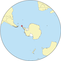
Robert Island or Mitchells Island or Polotsk Island or Roberts Island is an island 112 miles long and 8 miles wide, lying between Nelson Island and Greenwich Island in the South Shetland Islands, all within the British Antarctic Territory.
The surface area of Robert Island is 51 square miles.[1] The name "Robert Island" dates back to at least 1821 and is now established in international usage.
Outside links
References
- ↑ L.L. Ivanov. Antarctica: Livingston Island and Greenwich, Robert, Snow and Smith Islands. Scale 1:120000 topographic map. Troyan: Manfred Wörner Foundation, 2009. ISBN 978-954-92032-6-4
| The South Shetland Islands, British Antarctic Territory |
|---|
|
Bridgeman • Clarence • Cornwallis • Craggy • Deception • Elephant • Gibbs • Greenwich • Half Moon • Heywood • King George • Livingston • Low • Nelson • Penguin • Robert • Rowett • Rugged • Smith • Snow |
