Difference between revisions of "Cemais Hundred"
(Created page with "Pembrokeshire showing the hundred of Cemais '''Cemais''' (sometimes spelled '''Kemes''' after one of the several variations fou...") |
|||
| Line 1: | Line 1: | ||
| + | {{county|Pembroke}} | ||
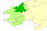
[[image:LDCemaisHundred.png|thumb|200px|right|Pembrokeshire showing the hundred of Cemais]] | [[image:LDCemaisHundred.png|thumb|200px|right|Pembrokeshire showing the hundred of Cemais]] | ||
'''Cemais''' (sometimes spelled '''Kemes''' after one of the several variations found in mediæval orthography) was a cantref of the Kingdom of Dyfed, and thence a hundred of [[Pembrokeshire]]. It occuies the coastal area between the [[River Teifi|Teifi]] estuary and [[Fishguard]], and the northern and southern slopes of the [[Preseli Hills]], and has an area of about 88,700 acres. The [[Afon Nyfer]] divided it into two commotes: ''Is Nyfer'' to the north and ''Uwch Nyfer'' to the south.<ref>Charles, B. G. (1992) ''The Placenames of Pembrokeshire''. Aberystwyth: National Library of Wales ISBN 0-907158-58-7, p. 25</ref> | '''Cemais''' (sometimes spelled '''Kemes''' after one of the several variations found in mediæval orthography) was a cantref of the Kingdom of Dyfed, and thence a hundred of [[Pembrokeshire]]. It occuies the coastal area between the [[River Teifi|Teifi]] estuary and [[Fishguard]], and the northern and southern slopes of the [[Preseli Hills]], and has an area of about 88,700 acres. The [[Afon Nyfer]] divided it into two commotes: ''Is Nyfer'' to the north and ''Uwch Nyfer'' to the south.<ref>Charles, B. G. (1992) ''The Placenames of Pembrokeshire''. Aberystwyth: National Library of Wales ISBN 0-907158-58-7, p. 25</ref> | ||
| Line 8: | Line 9: | ||
==References and notes== | ==References and notes== | ||
<references/> | <references/> | ||
| − | {{ | + | |
| + | ==Outside links== | ||
| + | *Location map: {{wmap|52.0|-4.8|zoom=12}} | ||
{{Pembrokeshire hundreds}} | {{Pembrokeshire hundreds}} | ||
Revision as of 13:55, 20 January 2018
Cemais (sometimes spelled Kemes after one of the several variations found in mediæval orthography) was a cantref of the Kingdom of Dyfed, and thence a hundred of Pembrokeshire. It occuies the coastal area between the Teifi estuary and Fishguard, and the northern and southern slopes of the Preseli Hills, and has an area of about 88,700 acres. The Afon Nyfer divided it into two commotes: Is Nyfer to the north and Uwch Nyfer to the south.[1]
It was occupied by the Normans in the 12th century, and made part of the March, but remained exclusively Welsh-speaking. The initial power-base of the Marcher Lordship was at Nevern, but was soon moved to the borough of Newport, which remains the seat of the Lords of Cemais in modern times. Nevern was the ecclesiastical centre of the cantref, and may have been the seat of a bishop.[2] George Owen was Lord of Cemais 1574-1613 and produced a detailed parish-by-parish description of the Lordship in his second book.[3]
The Hundred of Cemais evolved from the cantref at the time of the Laws in Wales Acts 1535–1542, by transferring the parish of Llantood to Cilgerran Hundred and adding a small area of Gwarthaf cantref.[4]
References and notes
- ↑ Charles, B. G. (1992) The Placenames of Pembrokeshire. Aberystwyth: National Library of Wales ISBN 0-907158-58-7, p. 25
- ↑ Williams, A. H. (1941) An Introduction to the History of Wales: Volume I: Prehistoric Times to 1063. Cardiff: University of Wales Press, p. 120
- ↑ Charles, B. G. (1973) The Second Book of George Owen's "Description of Pembrokeshire" in National Library of Wales Journal V, 1973, pp. 265-285
- ↑ As defined in the 1851 census
Outside links
- Location map: 52°0’0"N, 4°48’-0"W
| Hundreds of Pembrokeshire |
|---|
|
Cilgerran • Cemais • Dewisland • Roose (including Haverfordwest) • Castlemartin (including Pembroke) • Narberth (including Tenby) • Dungleddy |
