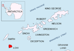
Low Island, South Shetland Islands
| Low Island | |
| Location | |
| Location: | 63°16’60"S, 62°8’60"W |
| Data | |
Low Island is an island 9 miles long and 5 miles wide, lying 14 miles southeast of Smith Island in the South Shetland Islands, within the British Antarctic Territory. The island is separated from Smith Island by Osmar Strait.
Low Island was so named because of its low elevation. It was known to sealers in 1820, and the name ‘Low Island’ has been established in international usage for 100 years. A historical name was 'Jameson Island' or 'Jamesons Island'
Map
- South Shetland Islands: Smith and Low Islands. Scale 1:150000 topographic map No. 13677. British Antarctic Survey, 2009.
Outside links
References
| The South Shetland Islands, British Antarctic Territory |
|---|
|
Bridgeman • Clarence • Cornwallis • Craggy • Deception • Elephant • Gibbs • Greenwich • Half Moon • Heywood • King George • Livingston • Low • Nelson • Penguin • Robert • Rowett • Rugged • Smith • Snow |
