Lynch Island: Difference between revisions
No edit summary |
|||
| Line 7: | Line 7: | ||
|latitude=-60.65 | |latitude=-60.65 | ||
|longitude=-45.6 | |longitude=-45.6 | ||
|map=Lynch Island by Coronation and Signy - South Orkney Islands, BAT.svg | |||
|summit= | |summit= | ||
}} | }} | ||
Latest revision as of 15:01, 21 May 2022
| Lynch Island | |
| Location | |
| Location: | 60°39’-0"S, 45°36’0"W |
| Data | |
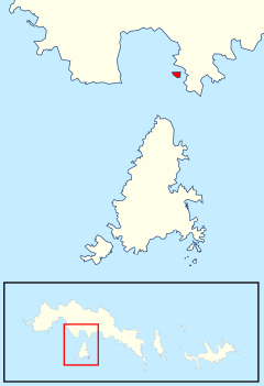
Lynch Island is an island lying in the eastern part of Marshall Bay, close off the south coast of Coronation Island, the largest of the South Orkney Islands in the British Antarctic Territory.
The island was roughly charted in 1912–13 by Petter Sørlle, a Norwegian whaling captain, and surveyed in 1933 by Discovery Investigations personnel. The island was resurveyed in 1948–49 by the Falkland Islands Dependencies Survey and named by the UK Antarctic Place-Names Committee for Thomas Lynch, an American sealer who visited the South Orkney Islands in the schooner Express in 1880.
Antarctic Specially Protected Area
The island has been designated an Antarctic Specially Protected Area for its biological values, especially its relatively luxuriant plant communities. The continent's only two flowering plants, Antarctic hair grass (Deschampsia antarctica)| and Antarctic pearlwort (Colobanthus quitensis), are abundant. The soils associated with the grass swards contain a rich invertebrate fauna.[1]
References
- ↑ "Lynch Island, South Orkney Islands". Management Plan for Antarctic Specially Protected Area No. 110: Measure 1. Antarctic Treaty Secretariat. 2000. http://www.ats.aq/documents/recatt/Att201_e.pdf. Retrieved 2013-09-22.
- Gazetteer and Map of The British Antarctic Territory: Lynch Island
