Clarence Island: Difference between revisions
Created page with "{{Infobox island |name=Clarence Island |territory=British Antarctic Territory |group=South Shetland Islands |map=South Shetland Islands Map.png |map csption=The South Shetland..." |
|||
| (One intermediate revision by the same user not shown) | |||
| Line 3: | Line 3: | ||
|territory=British Antarctic Territory | |territory=British Antarctic Territory | ||
|group=South Shetland Islands | |group=South Shetland Islands | ||
|map=South Shetland Islands | |map=Clarence Island - South Shetland Islands.svg | ||
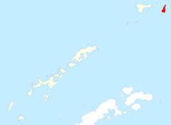
|map | |map caption=Clarence among the South Shetland Islands | ||
|latitude=-61.2 | |latitude=-61.2 | ||
|longitude=-54.083 | |longitude=-54.083 | ||
| Line 18: | Line 18: | ||
==Outside links== | ==Outside links== | ||
*{{ | *{{basgaz}} | ||
==References== | ==References== | ||
Latest revision as of 16:23, 4 December 2022
| Clarence Island | |
| Location | |
| Location: | 61°12’0"S, 54°4’59"W |
| Highest point: | Mount Irving, 7,546 feet |
| Data | |
Clarence Island is 12 miles long and the easternmost of the South Shetland Islands, within the British Antarctic Territory. The name dates back to at least 1821 and is now established in international usage.
Ernest Shackleton saw Clarence Island on his famous boat voyage but landed on Elephant Island.
Mount Irving, 7,546 feet high, rises 2 miles north of Cape Bowles, the southernmost point.
There are two small islands a mile east of Clarence Island; the northern one is named Sugarloaf Island, at 61°10’59"S, 54°0’0"W. Chinstrap Cove lies on the northwest coast of the island.
Outside links
- Gazetteer and Map of The British Antarctic Territory: Clarence Island
References
| The South Shetland Islands, British Antarctic Territory |
|---|
|
Bridgeman • Clarence • Cornwallis • Craggy • Deception • Elephant • Gibbs • Greenwich • Half Moon • Heywood • King George • Livingston • Low • Nelson • Penguin • Robert • Rowett • Rugged • Smith • Snow |
