Snow Island: Difference between revisions
Jump to navigation
Jump to search
No edit summary |
|||
| Line 18: | Line 18: | ||
==Outside links== | ==Outside links== | ||
*{{ | *{{basgaz}} | ||
==References== | ==References== | ||
Latest revision as of 13:13, 23 October 2022
| Snow Island | |
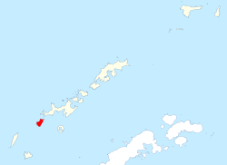
 Snow Island in the South Shetland Islands. | |
|---|---|
| Location | |
| Location: | 62°46’59"S, 61°22’59"W |
| Area: | 46.5 square miles |
| Data | |
Snow Island or Isla Nevada is a completely ice-covered island, 10 miles by 5 miles in size, lying some 8 miles southwest of Livingston Island in the South Shetland Islands, within the British Antarctic Territory.
The island's surface area is 46.5 square miles.[1]
This island was known to both American and British sealers as early as 1820, and the name has been well established in international usage for over 100 years.
Outside links
- Gazetteer and Map of The British Antarctic Territory: Snow Island
References
- ↑ L.L. Ivanov. Antarctica: Livingston Island and Greenwich, Robert, Snow and Smith Islands. Scale 1:120000 topographic map. Troyan: Manfred Wörner Foundation, 2009. ISBN 978-954-92032-6-4
| The South Shetland Islands, British Antarctic Territory |
|---|
|
Bridgeman • Clarence • Cornwallis • Craggy • Deception • Elephant • Gibbs • Greenwich • Half Moon • Heywood • King George • Livingston • Low • Nelson • Penguin • Robert • Rowett • Rugged • Smith • Snow |