Difference between revisions of "County Galway"
m |
|||
| (4 intermediate revisions by 2 users not shown) | |||
| Line 2: | Line 2: | ||
|name=County Galway | |name=County Galway | ||
|irish=Contae na Gaillimhe | |irish=Contae na Gaillimhe | ||
| − | |map image= | + | |map image=Galway Ireland (BI Sect 7).svg |
|picture=Connemara National Park.jpg | |picture=Connemara National Park.jpg | ||
|picture caption=Connemara | |picture caption=Connemara | ||
|province=[[Connaught]] | |province=[[Connaught]] | ||
|area= | |area= | ||
| − | |||
|county town=[[Galway]] | |county town=[[Galway]] | ||
}} | }} | ||
| − | The '''County of Galway''' is a large [[Counties of the Republic of Ireland| | + | The '''County of Galway''' is a large [[Counties of the Republic of Ireland|shire]] in the west of the [[Republic of Ireland]], in the province of [[Connaught]]. It is named after the city of [[Galway]]. The population of the county was 250,541 in 2011, down from its peak of 440,198 in 1841.<ref>[http://beyond2020.cso.ie/Census/TableViewer/tableView.aspx?ReportId=75467 Census 2006 - Population of each province, county and city]</ref> |
| − | {{ | + | ==Geography== |
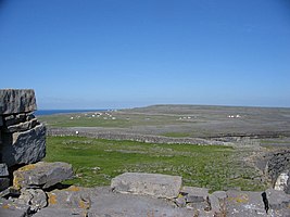
| + | [[Image:dunaonghasa2.jpg|thumb|267px|A view over the karst landscape on [[Inishmore]], from Dún Aengus, an ancient stone fort.]] | ||
| + | County Galway is home to [[Lough Corrib]] (the largest lake in [[Republic of Ireland|the Republic of Ireland]]) the Na Beanna Beola ([[Twelve Bens]]) mountain range, Na Sléibhte Mhám Toirc (the Maum Turk mountains), and the low mountains of Sliabh Echtghe (Slieve Aughty). The highest point in the county is one of the Twelve Bens, Benbaun, at 2,392ft. | ||
| + | |||
| + | ===Climate=== | ||
| + | The location of County Galway, situated on the west coast of Ireland, allows it to be directly influenced by the Gulf Stream. Temperature extremes are rare and short lived, though inland areas, particularly east of the Corrib, can boast some of the highest recorded temperatures of the summer in the island of Ireland (sometimes exceeding 30 °C); though these temperatures only occur when land warmed east winds sweep the area; the opposite effect can occur in the winter. Overall, however, Galway is influenced mainly by Atlantic airstreams which bring ample rainfall in between the fleeting sunshine. Rainfall occurs in every month of the year, though the late autumn and winter months can be particularly wet as Atlantic cyclonic activity increases and passes over and around the area, and which is why Galway tends to bear the brunt of severe windstorms that can occur between August and March. The county on average receives about 1300mm of rainfall annually, though some areas along the west coast of the county can receive up to 1900mm and beyond. Extreme weather such as blizzards, thunderstorms, flash flooding and hail, though rare, can and do occur, particularly when air masses of continental origin are undercut by more humid and unstable Atlantic flows. | ||
| + | |||
| + | ===Flora and fauna=== | ||
| + | One of the least densely populated counties, County Galway harbours a variety of wildlife. The region's biodiversity is best represented by Connemara National Park, situated in the west of the county. | ||
| + | |||
| + | ===Largest settlements in County Galway=== | ||
| + | # [[Galway]], 76,778 | ||
| + | # [[Tuam]], 8,242 | ||
| + | # [[Ballinasloe]], 6,659 | ||
| + | # [[Loughrea]], 5,062 | ||
| + | # [[Oranmore]], 4,799 | ||
| + | |||
| + | ==Towns and villages== | ||
| + | {{parishliststart}} | ||
| + | * [[Ahascragh]] | ||
| + | * [[Ardrahan]] | ||
| + | * [[Athenry]] | ||
| + | * [[Aughrim, County Galway|Aughrim]] | ||
| + | * [[Ballinasloe]] | ||
| + | * [[Ballinderreen]] | ||
| + | * [[Ballyconneely]] | ||
| + | * [[Ballygar]] | ||
| + | * [[Ballymacward]] | ||
| + | * [[Ballymoe]] | ||
| + | * [[Ballynahinch, County Galway|Ballynahinch]] | ||
| + | * [[Barna]] | ||
| + | * [[Bealadangan]] | ||
| + | * [[Belclare]] | ||
| + | * [[Bullaun, County Galway|Bullaun]] | ||
| + | * [[Camus, County Galway|Camus]] | ||
| + | * [[Carnmore]] | ||
| + | * [[Carraroe]] | ||
| + | * [[Casla]] | ||
| + | * [[Castleblakeney]] | ||
| + | * [[Castlegar, County Galway|Castlegar]] | ||
| + | * [[Claregalway]] | ||
| + | * [[Clarinbridge]] | ||
| + | * [[Cleggan]] | ||
| + | * [[Clifden]] | ||
| + | * [[Clonbur]] | ||
| + | * [[Corofin, County Galway|Corofin]] | ||
| + | * [[Annaghdown|Corrandulla]] | ||
| + | * [[Corr na Móna]] | ||
| + | * [[Craughwell]] | ||
| + | * [[Dunmore, County Galway|Dunmore]] | ||
| + | * [[Eyrecourt]] | ||
| + | * [[Furbo, County Galway|Furbo]] | ||
| + | * [[Glenamaddy]] | ||
| + | * [[Gort]] | ||
| + | * [[Headford]] | ||
| + | * [[Hollygrove, County Galway|Hollygrove]] | ||
| + | * [[Inverin]] | ||
| + | * [[Kilcolgan]] | ||
| + | * [[Kilconly]] | ||
| + | * [[Kilconnell]] | ||
| + | * [[Kilkerrin]] | ||
| + | * [[Kilkieran]] | ||
| + | * [[Killimor]] | ||
| + | * [[Kilronan]] | ||
| + | * [[Kiltullagh]] | ||
| + | * [[Kinvara]] | ||
| + | * [[Lawrencetown, County Galway|Laurencetown]] | ||
| + | * [[Leenaun]] | ||
| + | * [[Lettercallow]] | ||
| + | * [[Letterfrack]] | ||
| + | * [[Lettermore]] | ||
| + | * [[Loughrea]] | ||
| + | * [[Maam Cross]] | ||
| + | * [[Maum]] | ||
| + | * [[Menlough]] | ||
| + | * [[Milltown, County Galway|Milltown]] | ||
| + | * [[Monivea]] | ||
| + | * [[Mountbellew]] | ||
| + | * [[Mountshannon]] | ||
| + | * [[Moycullen]] | ||
| + | * [[Muckanaghederdauhaulia]] | ||
| + | * [[Maree]] | ||
| + | * [[Newbridge, County Galway|Newbridge]] | ||
| + | * [[New Inn, County Galway|New Inn]] | ||
| + | * [[Oranmore]] | ||
| + | * [[Oughterard]] | ||
| + | * [[Peterswell]] | ||
| + | * [[Portumna]] | ||
| + | * [[Recess, County Galway|Recess]] | ||
| + | * [[Rosmuck]] | ||
| + | * [[Rossaveal]] | ||
| + | * [[Roundstone, County Galway|Roundstone]] | ||
| + | * [[Roscam]] | ||
| + | * [[Skehana]] | ||
| + | * [[Spiddal]] | ||
| + | * [[Tuam]] | ||
| + | * [[Turloughmore]] | ||
| + | * [[Williamstown, County Galway|Williamstown]] | ||
| + | * [[Woodford, County Galway|Woodford]] | ||
| + | {{parishlistend}} | ||
| + | |||
| + | ==History== | ||
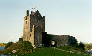
| + | [[File:Galway 1, Ireland.jpg|right|thumb|[[Dunguaire Castle]], built c. 1520]] | ||
| + | The first inhabitants in the Galway area arrived over 7000 years ago. Shell middens indicate the existence of people as early as 5000 BC. | ||
| + | |||
| + | The county originally comprised several kingdoms and territories which predate its formation. These kingdoms included [[Aidhne]], [[Uí Maine]], [[Maigh Seóla]], [[Conmhaícne Mara]], [[Soghain]] and [[Máenmaige]]. County Galway became an official entity around AD 1569. | ||
| + | |||
| + | With the arrival of Christianity many monasteries were built in the county. Monasteries kept written records of events in the area and of its people. These were followed by a number of law-tracts, genealogies, annals and miscellaneous accounts. | ||
| + | |||
| + | ==Outside links== | ||
| + | {{commons}} | ||
| + | *[http://census.cso.ie/sapmap2011/Results.aspx?Geog_Type=GA&Geog_Code=03#T3_300 Census 2011 SAPS - Irish language stats] | ||
| + | *[http://www.countygalway.com/ Tourist information website] | ||
| + | *[http://maps.yahoo.com/#mvt=m&lat=53.273885&lon=-9.048349&zoom=10 Map of Galway County] | ||
| + | *[http://www.flirtfm.org/ *FLIRT FM* Galways Student Radio Station NUIG/GMIT] | ||
| + | *[http://www.galwaygaa.ie/ Galway GAA] | ||
| + | *[http://www.tourguides.ie/guides.html?lang=1&qua=12&o=a&Submit=Search Galway Tour Guides ] | ||
| + | *[http://www.galway-ireland.ie/ County Galway Guide] | ||
| + | *[http://www.galwayindependent.com/ local newspaper] | ||
| + | *Extensive [http://www.thedirectory-ireland.com/articles/article-2.html list] of places in County Galway. | ||
| + | *[http://www.gaelscoileanna.ie/assets/Staitistic%C3%AD-2010-2011_Gaeilge.pdf/ Gaelscoil stats] | ||
| + | *[http://www.cso.ie/en/media/csoie/census/census2006results/volume9/volume_9_irish_language_entire_volume.pdf Irish Census 2006 ] | ||
| + | * [http://www.ahg.gov.ie/ie/Straiteis20BliaindonGhaeilge/Foilseachain/Staid%C3%A9ar%20Cuimsitheach%20Teangeola%C3%ADoch%20ar%20%C3%9As%C3%A1id%20na%20Gaeilge%20sa%20Ghaeltacht%20%28achoimre%29.pdf Gaeltacht Comprehensive Language Study 2007] | ||
| + | |||
| + | ==References== | ||
| + | {{reflist}} | ||
| + | |||
| + | * ''History of Galway'', James Hardiman, 1820 | ||
| + | * ''Education in the Diocese of Kilmachduagh in the nineteenth century'', Sr. Mary de Lourdes Fahy, Convent of Mercy, Gort, 1972 | ||
| + | * ''The Anglo-Normans and their castles in County Galway'', Patrick Holland, pp. 1–26, in ''Galway:History and Society'', 1996. ISBN 0-906602-75-0 | ||
| + | * ''From Warlords to Landlords: Political and Social Change in Galway 1540-1640'', Bernadette Cunningham, pp. 97–130, op.cit. | ||
| + | * ''The Politics of the 'Protestant Ascendency': County Galway 1650-1832'', James Kelly, pp. 229–270, op.cit. | ||
| + | * ''The Galway Tribes as Landowners and Gentry'', Patrick Melville, pp. 319–370, op.cit. | ||
| + | * ''Scríobhaithe Lámhscríbhinní Gaeilge i nGaillimh 1700-1900'', William Mahon, pp. 623–250, op.cit. | ||
| + | * ''Early Eccleiastical Settlement Names of County Galway'', Dónall Mac Giolla Easpaig, pp. 795–816, op. cit | ||
{{Irish county}} | {{Irish county}} | ||
Latest revision as of 00:48, 30 January 2016
| County Galway Irish: Contae na Gaillimhe Republic of Ireland | |
 Connemara | |
|---|---|

| |
| [Interactive map] | |
| Province: | Connaught |
| Area: | 2,374 square miles |
| Population: | 250,541 |
| County seat: | Galway |
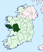
The County of Galway is a large shire in the west of the Republic of Ireland, in the province of Connaught. It is named after the city of Galway. The population of the county was 250,541 in 2011, down from its peak of 440,198 in 1841.[1]
Contents
Geography

County Galway is home to Lough Corrib (the largest lake in the Republic of Ireland) the Na Beanna Beola (Twelve Bens) mountain range, Na Sléibhte Mhám Toirc (the Maum Turk mountains), and the low mountains of Sliabh Echtghe (Slieve Aughty). The highest point in the county is one of the Twelve Bens, Benbaun, at 2,392ft.
Climate
The location of County Galway, situated on the west coast of Ireland, allows it to be directly influenced by the Gulf Stream. Temperature extremes are rare and short lived, though inland areas, particularly east of the Corrib, can boast some of the highest recorded temperatures of the summer in the island of Ireland (sometimes exceeding 30 °C); though these temperatures only occur when land warmed east winds sweep the area; the opposite effect can occur in the winter. Overall, however, Galway is influenced mainly by Atlantic airstreams which bring ample rainfall in between the fleeting sunshine. Rainfall occurs in every month of the year, though the late autumn and winter months can be particularly wet as Atlantic cyclonic activity increases and passes over and around the area, and which is why Galway tends to bear the brunt of severe windstorms that can occur between August and March. The county on average receives about 1300mm of rainfall annually, though some areas along the west coast of the county can receive up to 1900mm and beyond. Extreme weather such as blizzards, thunderstorms, flash flooding and hail, though rare, can and do occur, particularly when air masses of continental origin are undercut by more humid and unstable Atlantic flows.
Flora and fauna
One of the least densely populated counties, County Galway harbours a variety of wildlife. The region's biodiversity is best represented by Connemara National Park, situated in the west of the county.
Largest settlements in County Galway
- Galway, 76,778
- Tuam, 8,242
- Ballinasloe, 6,659
- Loughrea, 5,062
- Oranmore, 4,799
Towns and villages
- Ahascragh
- Ardrahan
- Athenry
- Aughrim
- Ballinasloe
- Ballinderreen
- Ballyconneely
- Ballygar
- Ballymacward
- Ballymoe
- Ballynahinch
- Barna
- Bealadangan
- Belclare
- Bullaun
- Camus
- Carnmore
- Carraroe
- Casla
- Castleblakeney
- Castlegar
- Claregalway
- Clarinbridge
- Cleggan
- Clifden
- Clonbur
- Corofin
- Corrandulla
- Corr na Móna
- Craughwell
- Dunmore
- Eyrecourt
- Furbo
- Glenamaddy
- Gort
- Headford
- Hollygrove
- Inverin
- Kilcolgan
- Kilconly
- Kilconnell
- Kilkerrin
- Kilkieran
- Killimor
- Kilronan
- Kiltullagh
- Kinvara
- Laurencetown
- Leenaun
- Lettercallow
- Letterfrack
- Lettermore
- Loughrea
- Maam Cross
- Maum
- Menlough
- Milltown
- Monivea
- Mountbellew
- Mountshannon
- Moycullen
- Muckanaghederdauhaulia
- Maree
- Newbridge
- New Inn
- Oranmore
- Oughterard
- Peterswell
- Portumna
- Recess
- Rosmuck
- Rossaveal
- Roundstone
- Roscam
- Skehana
- Spiddal
- Tuam
- Turloughmore
- Williamstown
- Woodford
History

The first inhabitants in the Galway area arrived over 7000 years ago. Shell middens indicate the existence of people as early as 5000 BC.
The county originally comprised several kingdoms and territories which predate its formation. These kingdoms included Aidhne, Uí Maine, Maigh Seóla, Conmhaícne Mara, Soghain and Máenmaige. County Galway became an official entity around AD 1569.
With the arrival of Christianity many monasteries were built in the county. Monasteries kept written records of events in the area and of its people. These were followed by a number of law-tracts, genealogies, annals and miscellaneous accounts.
Outside links
| ("Wikimedia Commons" has material about County Galway) |
- Census 2011 SAPS - Irish language stats
- Tourist information website
- Map of Galway County
- *FLIRT FM* Galways Student Radio Station NUIG/GMIT
- Galway GAA
- Galway Tour Guides
- County Galway Guide
- local newspaper
- Extensive list of places in County Galway.
- Gaelscoil stats
- Irish Census 2006
- Gaeltacht Comprehensive Language Study 2007
References
- History of Galway, James Hardiman, 1820
- Education in the Diocese of Kilmachduagh in the nineteenth century, Sr. Mary de Lourdes Fahy, Convent of Mercy, Gort, 1972
- The Anglo-Normans and their castles in County Galway, Patrick Holland, pp. 1–26, in Galway:History and Society, 1996. ISBN 0-906602-75-0
- From Warlords to Landlords: Political and Social Change in Galway 1540-1640, Bernadette Cunningham, pp. 97–130, op.cit.
- The Politics of the 'Protestant Ascendency': County Galway 1650-1832, James Kelly, pp. 229–270, op.cit.
- The Galway Tribes as Landowners and Gentry, Patrick Melville, pp. 319–370, op.cit.
- Scríobhaithe Lámhscríbhinní Gaeilge i nGaillimh 1700-1900, William Mahon, pp. 623–250, op.cit.
- Early Eccleiastical Settlement Names of County Galway, Dónall Mac Giolla Easpaig, pp. 795–816, op. cit
| Counties of the Republic of Ireland |
|---|
|
Carlow • Cavan • Clare • Cork • Donegal • Dublin • Galway • Kerry • Kildare • Kilkenny • Laois • Leitrim • Limerick • Longford • Louth • Mayo • Meath • Monaghan • Offaly • Roscommon • Sligo • Tipperary • Waterford • Westmeath • Wexford • Wicklow |