Cardiff
| Cardiff Welsh: Caerdydd | |
| Glamorgan | |
|---|---|
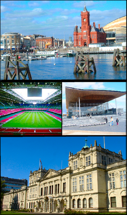
 Cardiff Bay, the Millennium Stadium, the Senedd, Cardiff University | |
| Location | |
| Grid reference: | ST180766 |
| Location: | 51°28’57"N, 3°10’53"W |
| Data | |
| Population: | 324,800 (est) |
| Post town: | Cardiff |
| Postcode: | CF3, CF5, CF10-11, CF14-15, CF23-24 |
| Dialling code: | 029 |
| Local Government | |
| Council: | Cardiff |
| Parliamentary constituency: |
Cardiff West Cardiff South and Penarth Cardiff North Cardiff Central |
Cardiff is a major city in the southeast of Glamorgan, of which it is the county town. Cardiff is the largest city in Wales and was declared the Capital of Wales in 1955. The city is the chief commercial centre of south Wales, the base for most national cultural and sporting institutions, the Welsh national media, and the seat of the Welsh Assembly.
According to recent estimates, the population of the city is 324,800, while the wider metropolitan area has a population of nearly 1.1 million, more than a third of the total Welsh population. Cardiff is a significant tourism centre and the most popular visitor destination in Wales, drawing 14.6 million visitors in 2009.[1]
A small town until the early 19th century, Cardiff rose to prominence as a major port in the later eighteenth century for the transport of copper and later coal. The port facilities and associated new suburbs were developed by the Earl of Bute, from whom Butetown is named. As the industrial revolution took hold and the mines of the Glamorgan and Monmouthshire valleys sent their coal to the port, Cardiff grew into a major city.
Cardiff was made a city in 1905. It was proclaimed Capital of Wales in 1955 (although the significance is unclear. In that year, the Minister for Welsh Affairs, Gwilym Lloyd-George, commented in a Parliamentary written answer that "no formal measures are necessary to give effect to this decision"). Since the 1990s Cardiff has seen significant development with a new waterfront area at Cardiff Bay which contains the Senedd building, home to the Welsh Assembly and the Wales Millennium Centre arts complex.
Sporting venues in the city include the Millennium Stadium (the national stadium for the Wales national rugby union team and the Wales national football team), SWALEC Stadium (the home of Glamorgan County Cricket Club), Cardiff City Stadium (the home of Cardiff City football team and Cardiff Blues rugby union team) and Cardiff International Sports Stadium (the home of Cardiff Amateur Athletic Club). The city is also HQ of the Wales Rally GB and was awarded with the European City Of Sport in 2009 due to its role in hosting major international sporting events.
Name of the city

The name "Cardiff" derived from the city's Welsh name, Caerdydd. This is believed to derive from the British (or Old Welsh) language meaning "the fort on the Taff".
The fort refers to that established by the Romans. "Dydd" or "Diff" are both modifications of "Taff", the river on which Cardiff Castle stands. According to Professor Hywel Wyn Owen, a leading modern authority on toponymy, the Welsh pronunciation of "Caerdyff" as "Caerdydd" shows the colloquial alternation of Welsh "-f" and "-dd".[2]
The antiquarian William Camden (1551–1623) suggested that the name Cardiff may derive from the name "Caer-Didi" ("the Fort of Didius"), given in honour of Aulus Didius Gallus, governor of a nearby province at the time when the Roman fort was established. Although some websites repeat this theory as fact, it is disputed by modern scholars on linguistic grounds.
Geography
The centre of Cardiff is relatively flat and is bounded by hills on the outskirts to the east, north and west. Its geographic features were influential in its development as the world's largest coal port, most notably its proximity and easy access to the coal fields of the south Wales valleys.
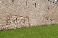
Cardiff is built on reclaimed marshland on a bed of Triassic stones; this reclaimed marshland stretches from Chepstow in Monmouthshire to the Ely Estuary,[3] which is the natural boundary of Cardiff and the Vale of Glamorgan. Triassic landscapes of this part of the world are usually shallow and low-lying which accounts and explains the flatness of the centre of Cardiff.[4] The classic Triassic marl, sand and conglomerate rocks are used predominantly throughout Cardiff as building materials. Many of these Triassic rocks have a purple complexion, especially the coastal marl found near Penarth. One of the Triassic rocks used in Cardiff is "Radyr Stone", a freestone which as it name suggests is quarried in the Radyr district.[5] Cardiff has also imported some materials for buildings: Devonian sandstones (the Old Red Sandstone) from the Brecon Beacons has been used. Most famously, the buildings of Cathays Park, the civic centre in the centre of the city, are built of Portland stone which was imported from Dorset.[6] A widely used building stone in Cardiff is the yellow-grey Liassic limestone rock of the Vale of Glamorgan, including the very rare "Sutton Stone", a conglomerate of lias limestone and carboniferous limestone.[7]
West of Cardiff is Glamorgan's richest agricultural area where the shire broadens is gentle, verdant hills, and which land has been called "The Garden of Cardiff".[8]. The cityscape runs right up to Glamorgan's eastern boundary, the River Rhymney and indeed has suburbs beyond in Monmouthshire, reaching towards Newport. North of the city the hills of Glamorgan rise up toward the mountains
The foot of Cardiff is washed by the sea. The city centre lies above the seafront, but to the south Butetown stretches down to the old docks on Cardiff Bay. The area around Bay was known colloquially as Tiger Bay for generations, but since its redevelopment as a new centre for the city it has been dubbed simply "Cardiff Bay". The bay has been bottled in with the Cardiff Bay Barrage, and its tidal mudflats flooded permanently, the great bay turned into a freshwater lake. Beyond the barrage the Severn Estuary and Bristol Channel roll.
The River Taff winds through the centre of the city and together with the River Ely it flows into Cardiff Bay. The Rhymney is further east and flows directly into the Severn Estuary.
Cardiff is situated near the Glamorgan Heritage Coast, stretching westward from Penarth and Barry—commuter towns of Cardiff—with striped yellow-blue Jurassic limestone cliffs. The Glamorgan coast is the only part of the Celtic Sea that has exposed Jurassic (blue lias) geology. This stretch of coast, which has reefs, sandbanks and serrated cliffs, was a ship graveyard; ships sailing up to Cardiff during the industrial era often never made it as far as Cardiff as many were wrecked around this hostile coastline during west/south-westerly gales. Consequently, smuggling, deliberate shipwrecking and attacks on ships were common.[9]
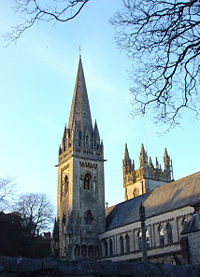
Llandaff Cathedral

Llandaff Cathedral stands in the suburb village of Llandaff in the niorth of the city. It has been part of Cardiff since 1922. The Diocese of Llandaff is one of the six dioceses of the Church in Wales.
The Cathedral’s full name is The Cathedral Church of SS Peter & Paul, Dyfrig, Teilo and Euddogwy.
In the sixth century St Dyfrig founded a monastic community close to the ford where the Roman road crossed the river Taff. He and his successors, St Teilo and Teilo's nephew, St Euddogwy, provide the latter part of the cathedral's dedication. The original church is entitely lost, though an old Celtic cross which predates the current cathedral still stands in the grounds, by the Chapter House door.
In 1107 Bishop Urban built the current church on the site of the old, and much of Urban's work remains. The Cathedral was extended in about 1220, at which time the West Front was built; considered to be one of the two or three most notable mediaeval works of art in Wales. The Chapter House followed in the next century and further work over the Middle Ages. St Teilo's tomb was a popular place of pilgrimage until the Reformation.
The Cathedral suffered in the Blitz during the Second World War and the current building has been heavily restored, giving it a lighter, more spacious aspect.
References
- ↑ Williams, Sally (7 July 2010). "City’s new look pulls in foreign tourists". South Wales Echo (Cardiff: Media Wales Ltd). http://www.walesonline.co.uk/cardiffonline/cardiff-news/2010/07/07/city-s-new-look-pulls-in-foreign-tourists-91466-26799475/. Retrieved 26 August 2010.
- ↑ Hywel Wyn Owen, The Place-names of Wales, 1998, ISBN 0-7083-1458-9
- ↑ "Cardiff Supplementary Planning Guidance: Archaeologically Sensitive Areas" (PDF). Cardiff County Council. 2006-07-20. http://www.cardiff.gov.uk/ObjView.asp?Object_ID=7004. Retrieved 2008-10-01.
- ↑ Radley, J. D.; Twitchett, R. J.; Mander, L.; Cope, J.C.W (2008). "Discussion on palaeoecology of the Late Triassic extinction event in the SW UK". Journal of the Geological Society (Geological Society of London) 165 (5): 988–992. doi:10.1144/0016-76492008-014. http://jgs.lyellcollection.org/cgi/content/full/165/5/988. Retrieved 2008-10-01.
- ↑ "Triassic building sandstone resources". http://www.englishstone.org.uk/documents/dimension%20stone%208.html. Retrieved 2008-07-07.
- ↑ "Geological Walks in Wales: Cathays Park" (PDF). Geologists Association South Wales. http://www.swga.org.uk/pdf/CathaysPark.pdf. Retrieved 2008-10-22.
- ↑ Iowerth, Dylan (1998). "Castell Morgraig". Castle Studies Group. http://www.castlewales.com/morgraig.html. Retrieved 2008-10-22.
- ↑ "The Garden of Cardiff". http://www.gardenofcardiff.com/. Retrieved 2008-05-20.
- ↑ "Smuggling Around Kenfig". Kenfig.org. http://www.kenfig.org.uk/smuggling.html. Retrieved 2008-04-19.
Outside links
- Cardiff, BBC
- Cardiff Council site
- Cardiff Records: the full text of the edition of historical records for Cardiff, edited by J. H. Matthews (1898–1905.) Part of British History Online.
- Cardiff Based weather and flooding info
- St Fagans, Cardiff
- OPENCities Monitor participant