Difference between revisions of "Becontree Hundred"
| Line 3: | Line 3: | ||
==History== | ==History== | ||
| − | The name is first recorded in the 1086 [[Domesday Book]] as ''Beuentreu'', meaning ''tree of a man called Beohha''.<ref name=mills/> The original tree, at [[Becontree Heath]], was the location that early hundred meetings took place.<ref name=mills/> In 1465 the Royal Liberty of Havering was formed in the eastern part of the hundred, comprising the parishes of Hornchurch, Romford and Havering-atte-Bower.<ref name=becontree_victoria>''[http://www.british-history.ac.uk/report.aspx?compid=42721 The hundred of Becontree: Introduction', A History of the County of Essex: Volume 5 (1966)]. Date accessed: 11 January 2008.</ref> Excluding the area of the liberty, the hundred contains the parishes of [[Barking]], [[Dagenham]], [[East Ham]], [[Ilford]] (also known as Great Ilford), [[Leyton]], [[Little Ilford]], [[Walthamstow]], [[Wanstead]] and [[West Ham]].<ref name=map>[http://www.british-history.ac.uk/image.aspx?compid=42740&filename=fig1.gif British History Online] - Map of Becontree Hundred, (1973)</ref> | + | The name is first recorded in the 1086 [[Domesday Book]] as ''Beuentreu'', meaning ''tree of a man called Beohha''.<ref name=mills/> The original tree, at [[Becontree Heath]], was the location that early hundred meetings took place.<ref name=mills/> In 1465 the [[Royal Liberty of Havering]] was formed in the eastern part of the hundred, comprising the parishes of Hornchurch, Romford and Havering-atte-Bower.<ref name=becontree_victoria>''[http://www.british-history.ac.uk/report.aspx?compid=42721 The hundred of Becontree: Introduction', A History of the County of Essex: Volume 5 (1966)]. Date accessed: 11 January 2008.</ref> Excluding the area of the liberty, the hundred contains the parishes of [[Barking]], [[Dagenham]], [[East Ham]], [[Ilford]] (also known as Great Ilford), [[Leyton]], [[Little Ilford]], [[Walthamstow]], [[Wanstead]] and [[West Ham]].<ref name=map>[http://www.british-history.ac.uk/image.aspx?compid=42740&filename=fig1.gif British History Online] - Map of Becontree Hundred, (1973)</ref> |
| − | The southern boundary with the [[Blackheath Hundred, Kent|Blackheath]] hundred of [[Kent]] is for the most part the [[River Thames]], except at North Woolwich where Kent trespasses over the river.<ref>[http://www.british-history.ac.uk/report.asp?compid=42740#s3 British History Online] - The Origin of North Woolwich, (1973)</ref> In the east the Havering liberty borders [[Chafford Hundred]]; and to the north [[Waltham Hundred|Waltham]] and [[Ongar Hundred|Ongar]] hundreds.<ref name=map/> The [[River Lea]] forms the western boundary with the Tower division of the [[Ossulstone Hundred|Ossulstone]] hundred of [[Middlesex]]. The [[River Roding]] runs roughly north to south through the area. | + | The southern boundary with the [[Blackheath Hundred, Kent|Blackheath]] hundred of [[Kent]] is for the most part the [[River Thames]], except at [[North Woolwich]] where Kent trespasses over the river.<ref>[http://www.british-history.ac.uk/report.asp?compid=42740#s3 British History Online] - The Origin of North Woolwich, (1973)</ref> In the east the Havering liberty borders [[Chafford Hundred]]; and to the north [[Waltham Hundred|Waltham]] and [[Ongar Hundred|Ongar]] hundreds.<ref name=map/> The [[River Lea]] forms the western boundary with the Tower division of the [[Ossulstone Hundred|Ossulstone]] hundred of [[Middlesex]]. The [[River Roding]] runs roughly north to south through the area. |
==References== | ==References== | ||
Revision as of 13:39, 4 October 2019
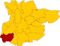
Becontree is a hundred in the south-west of the county of Essex.[1] Its area has been entirely absorbed by the growth of the conurbation spreading out from London; with its name reused in 1921 for the large Becontree estate.[2] It is by far the most populous of the hundreds, with a population, including the liberty of Havering, of 1,169,095 in 2011.
History
The name is first recorded in the 1086 Domesday Book as Beuentreu, meaning tree of a man called Beohha.[2] The original tree, at Becontree Heath, was the location that early hundred meetings took place.[2] In 1465 the Royal Liberty of Havering was formed in the eastern part of the hundred, comprising the parishes of Hornchurch, Romford and Havering-atte-Bower.[3] Excluding the area of the liberty, the hundred contains the parishes of Barking, Dagenham, East Ham, Ilford (also known as Great Ilford), Leyton, Little Ilford, Walthamstow, Wanstead and West Ham.[4]
The southern boundary with the Blackheath hundred of Kent is for the most part the River Thames, except at North Woolwich where Kent trespasses over the river.[5] In the east the Havering liberty borders Chafford Hundred; and to the north Waltham and Ongar hundreds.[4] The River Lea forms the western boundary with the Tower division of the Ossulstone hundred of Middlesex. The River Roding runs roughly north to south through the area.
References
- ↑ John Marius Wilson, Imperial Gazetteer of England and Wales, (1870-72)
- ↑ 2.0 2.1 2.2 Mills, A., Oxford Dictionary of London Place Names, (2001)
- ↑ The hundred of Becontree: Introduction', A History of the County of Essex: Volume 5 (1966). Date accessed: 11 January 2008.
- ↑ 4.0 4.1 British History Online - Map of Becontree Hundred, (1973)
- ↑ British History Online - The Origin of North Woolwich, (1973)
| Hundreds of Essex |
|---|
|
Barnstable • Becontree (including Havering liberty) • Chafford • Chelmsford • Clavering • Dengie (including Maldon) • Dunmow • Freshwell • Harlow • Hinckford • Lexden (including Colchester) • Ongar • Rochford • Tendring (including Harwich) • Thurstable • Uttlesford • Waltham • Winstree • Witham |
