Difference between revisions of "Bangor, Caernarfonshire"
m |
m (→The Menai Bridges) |
||
| (3 intermediate revisions by 2 users not shown) | |||
| Line 1: | Line 1: | ||
| − | + | {{Hatnote|For the town in Downshire, see [[Bangor, County Down]]}} | |
| − | + | ||
{{Infobox town | {{Infobox town | ||
|name = Bangor | |name = Bangor | ||
| Line 47: | Line 46: | ||
===The Menai Bridges=== | ===The Menai Bridges=== | ||
| − | The two bridges across the Menai Strait to the [[Anglesey|Isle of Anglesey]] begin outside Bangor. The Britannia Bridge (1980, replacing the 1850 original) carries the A55 and the Menai Suspension Bridge (1825) the A5. These are major freight routes, bringing much of the trade between [[Great Britain]] and [[Ireland]], but also carry visitors to the island. | + | The two bridges across the Menai Strait to the [[Anglesey|Isle of Anglesey]] begin outside Bangor. The [[Britannia Bridge]] (1980, replacing the 1850 original) carries the A55 and the [[Menai Suspension Bridge]] (1825) the A5. These are major freight routes, bringing much of the trade between [[Great Britain]] and [[Ireland]], but also carry visitors to the island. |
===Railway=== | ===Railway=== | ||
| Line 57: | Line 56: | ||
While the building itself is not the oldest, and certainly not the biggest, the [[Diocese of Bangor]] is one of the oldest in Britain. | While the building itself is not the oldest, and certainly not the biggest, the [[Diocese of Bangor]] is one of the oldest in Britain. | ||
| + | {{clear}} | ||
<gallery> | <gallery> | ||
| − | + | File:Bangor Cathedral from Bangor Mountain.jpg|Bangor Cathedral from Bangor Mountain | |
| − | + | File:University_from_Bangor_Mountain.JPG|University of Wales, Bangor from Bangor Mountain | |
| − | + | File:Bangor Pier from across the Straits - geograph.org.uk - 787782.jpg|Bangor Pier from across the Straits | |
| − | + | File:Bangor High Street.jpg|The High Street, Bangor | |
| − | + | ||
</gallery> | </gallery> | ||
| Line 73: | Line 72: | ||
* [http://www.woodvine.com/bangor/ Bangor in old photographs] | * [http://www.woodvine.com/bangor/ Bangor in old photographs] | ||
* [http://www.geograph.org.uk/search.php?i=3491095 www.geograph.co.uk : photos of Bangor and surrounding area] | * [http://www.geograph.org.uk/search.php?i=3491095 www.geograph.co.uk : photos of Bangor and surrounding area] | ||
| + | {{Cities in the United Kingdom}} | ||
Latest revision as of 22:40, 17 January 2017
| Bangor | |
| Caernarfonshire | |
|---|---|
 Bangor | |
| Location | |
| Grid reference: | SH580722 |
| Location: | 53°13’41"N, 4°7’41"W |
| Data | |
| Population: | 21,735 (2008 estimate) |
| Post town: | Bangor |
| Postcode: | LL57 |
| Dialling code: | 01248 |
| Local Government | |
| Council: | Gwynedd |
| Parliamentary constituency: |
Arfon |
Bangor is a city on the Irish Sea coast of Caernarfonshire, near the easterly entrance of the Menai Strait which separates the island of Anglesey from Caernarfonshire. Bangor is one of the smallest cities in the United Kingdom, enjoying its city status by virtue of its Anglican cathedral.
Contents
The city
Bangor lies beneath the shadow of Bangor Mountain to the east of the city centre. Bangor claims to have the longest High Street in the United Kingdom. The Mountain's morning shadow falls across it and across the Glan Adda and Hirael areas are such that in winter, from November to March, some parts of the High Street see no direct sunlight. As the city has expanded with new housing, the estate of Maesgeirchen has run to the mountain's other flank, near Port Penrhyn.
Another mountain ridge rises to the north of the High Street, splitting the city centre from parts on the rise hanging over the shore of the Menai Strait, the latter known as Upper Bangor.
Bangor University provides much of the life of the town. The city's population is some 13,725 souls, to which about 10,000 students are added during the university term.
According to the census, 46.6% of the population can speak Welsh.

Bangor has two rivers. The River Adda is a largely culverted watercourse which only appears above ground at its western extremities near the Faenol estate. The River Cegin enters Port Penrhyn at the eastern edge of the city.
Port Penrhyn
Port Penrhyn, east of Bangor itself, was an important port in the 19th century, exporting the slates produced at the Penrhyn Quarry.
Sights in and around the city
The North Wales Path
Bangor lies at the western end of the North Wales Path, a 60 mile long-distance coastal walking route to Prestatyn. Cyclists may also follow from Bangor routes 5, 8 and 85 of the National Cycle Network.
Garth Pier
Bangor's pier, named the Garth Pier, is 1,500 feet long (making it the second longest pier in Wales, the 9th longest in the British Isles. It seriously deteriorated after its heyday and was to have been demolished in 1974 due to its poor condition, but local support for the pier ensured that it survived. It gained a Grade II listed status, as it was considered one of the three finest surviving piers at the time. Restoration work eventually began in 1982 took six years to complete.
Garth Pier was re-opened to the public on Saturday, 7 May 1988.
The Menai Bridges
The two bridges across the Menai Strait to the Isle of Anglesey begin outside Bangor. The Britannia Bridge (1980, replacing the 1850 original) carries the A55 and the Menai Suspension Bridge (1825) the A5. These are major freight routes, bringing much of the trade between Great Britain and Ireland, but also carry visitors to the island.
Railway
Bangor railway station is on the North Wales Coast Line running between Crewe and Holyhead. It gives access to Anglesey and provides a fine spectacle fro travellers as it crosses the Menai Strait.
History
The origins of the city date back to the founding of a monastic establishment on the site of Bangor Cathedral by Saint Deiniol in the early 6th century AD. The name 'Bangor' itself is an old Welsh word for a type of fenced-in enclosure, such as was originally on the site of the cathedral. The present cathedral is a somewhat more recent building and has been extensively modified throughout the centuries.

While the building itself is not the oldest, and certainly not the biggest, the Diocese of Bangor is one of the oldest in Britain.
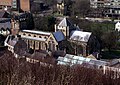
Bangor Cathedral from Bangor Mountain
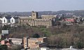
University of Wales, Bangor from Bangor Mountain
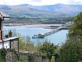
Bangor Pier from across the Straits
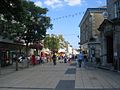
The High Street, Bangor


References
Outside links
- Bangor Civic Society
- The People of Bangor Community Group
- Bangor in old photographs
- www.geograph.co.uk : photos of Bangor and surrounding area
| Cities in the United Kingdom |
|---|
|
Aberdeen • Armagh • Bangor (Caernarfonshire) • Bangor (County Down) • Bath • Belfast • Birmingham • Bradford • Brighton and Hove • Bristol • Cambridge • Canterbury • Cardiff • Carlisle • Chelmsford • Chester • Chichester • Colchester • Coventry • Derby • Doncaster • Dundee • Dunfermline • Durham • Ely • Edinburgh • Exeter • Glasgow • Gloucester • Hereford • Inverness • Kingston upon Hull • Lancaster • Leeds • Leicester • Lichfield • Lincoln • Lisburn • Liverpool • City of London • Londonderry • Manchester • Milton Keynes • Newcastle upon Tyne • Newport • Newry • Norwich • Nottingham • Oxford • Perth • Peterborough • Plymouth • Portsmouth • Preston • Ripon • Rochester • Salford • Salisbury • Sheffield • Southampton • St Albans • St Asaph • St David's • Southend-on-Sea • Stirling • Stoke-on-Trent • Sunderland • Swansea • Truro • Wakefield • Wells • Westminster • Winchester • Wolverhampton • Worcester • Wrexham • York |