Plymouth
| Plymouth | |
| Devon | |
|---|---|
 View of Plymouth Hoe Waterfront | |
| Location | |
| Location: | 50°22’17"N, 4°8’33"W |
| Data | |
| Population: | 256,700 (2009 est) |
| Post town: | Plymouth |
| Postcode: | PL1-9 |
| Dialling code: | 01752 |
| Local Government | |
| Council: | Plymouth |
| Parliamentary constituency: |
Plymouth Moor View Plymouth Sutton & Devonport |
Plymouth is a city on the south coast of Devon. It is Devon's largest town and the major regional centre both of West Devon and for much of Cornwall. Plymouth stands between the mouths of the rivers Plym to the east and Tamar to the west, where they join Plymouth Sound. It has been the site a major naval port, Devonport, since the days of Queen Elizabeth I.
Today's Plymouth is made up of "The Three Towns"; Plymouth (or Sutton), Devonport and East Stonehouse which stands between the two. The old part of Plymouth is known as The Barbican, between the Plym and Plymouth Hoe, built around Sutton Harbour. Plymouth Hoe is a large flat-topped hill between Sutton and the Tamar. It is dominated by The Citadel, a fortress which still serves as a military establishment.
In the Bronze Age a settlement grew at Mount Batten. It became a trading port during the Roman Empire, and only later did the more prosperous village of Sutton, the current Plymouth, surpass it.
Throughout the Industrial Revolution Plymouth grew as a major shipping port, handling imports and passengers from the Americas, while the neighbouring town of Devonport grew as an important Royal Naval shipbuilding and dockyard town. The city's naval importance later led to its targeting and partial destruction during World War II, an act known as the Plymouth Blitz. After the war the city centre was completely rebuilt.
Plymouth's economy is still strongly influenced by shipbuilding, but has become a more service-based economy since the 1990s. It has the 9th largest university in the United Kingdom by number of students, the University of Plymouth, and the largest operational naval base in Western Europe – HMNB Devonport. Plymouth has ferry links to France and Spain and an airport with European services.
Lay of the land

Plymouth lies between the River Plym to the east and the River Tamar to the west; both rivers flow into the natural harbour of Plymouth Sound. The River Tamar forms the county boundary between Devon and Cornwall and its estuary forms the Hamoaze on which is sited Devonport Dockyard.
The River Plym, which flows off Dartmoor to the north-east, forms a smaller estuary to the east of the city called Cattewater. Plymouth Sound is protected from the sea by the Plymouth Breakwater, in use since 1814.[1] In the Sound is Drake's Island
The town
Plymouth was badly hit by German bombing during the Second World War. On 27 April 1944 Sir Patrick Abercrombie's Plan for Plymouth to rebuild the city after the Blitz was published; it called for the demolition of the few remaining pre-War buildings in the city centre and their replacement with wide, modern boulevards aligned east–west linked by a north–south avenue (Armada Way) connecting the railway station and Plymouth Hoe.[2] Prefabs had started to be built by 1946, and over 1,000 permanent council houses were built each year from 1951–57.[3] By 1964 over 20,000 new homes had been built, more than 13,500 of them permanent council homes and 853 built by the Admiralty.[3]
Plymouth is home to 28 parks,[4] the largest being Central Park.[5] Other sizeable green spaces include Victoria Park, Freedom Fields Park, Alexandra Park, Devonport Park and the Hoe.[4]
Plymouth Hoe
Plymouth Hoe is a flat hill of limestone cliffs[6] looking out over Plymouth Sound. Its scarp falls straight toward the sea, separated now by a coast road and promenade and a 1930s leisure pool and facilities built over the rocks.
The eastern part of the Hoe is dominated by the Royal Citadel, while the western part provides open space for the townsfolk. In this area stands Smeaton's Tower, built in 1759 as a lighthouse on rocks 14 miles off-shore, but dismantled and the top two thirds rebuilt on the Hoe in 1877.[7] Also it has a statue of Sir Francis Drake; a copy of that which stands on the Plymouth Road in his home town of Tavistock.
History
Early history
Artefacts dating from the Bronze Age to the Middle Iron Age have been found at Mount Batten showing that it was one of the main trading ports of the country at that time.[8]
The settlement of Plympton, further up the River Plym than the current Plymouth, was also an early trading port, but the river silted up in the early 11th century and forced the mariners and merchants to settle at the current day Barbican near the river mouth.[9] At the time this village was called Sutton, meaning south town.[9] The name Plymouth is from the River Plym, but the river name appears to be a back-formation from Plympton ("Plum-tree town"),[10] "Plymouth" by that name was first mentioned in a Pipe Roll of 1211.[11]
Early defence and Renaissance
During the Hundred Years' War a French attack (1340) burned a manor house and took some prisoners, but failed to get into the town.[12] In 1403 the town was burned by Breton people|Breton raiders.[13] A series of fortifications were built in the Tudor period, which include the four round towers featured on the city coat of arms; the remains of two of these can still be found at Mount Batten and at Sutton Pool below the Royal Citadel.[14]
During the 16th century locally produced wool was the major export commodity.[15] Plymouth was the home port for successful maritime traders, among them Sir John Hawkins, who led England's first venture into the Atlantic slave trade,[16] as well as Sir Francis Drake.[17]
According to legend, Drake insisted on completing his game of bowls on the Hoe before engaging the Spanish Armada in 1588.[17] Having finished the game, he and the captains of the fleet repaired to Devonport and made sail to intercept the Spaniards.
Seventeenth century
In 1620 the Pilgrim Fathers set sail for the New World from Plymouth, establishing Plymouth Colony – the second English colony in what is now the United States of America, and the first of New England.[18]
During the English Civil War Plymouth sided with the Parliamentarians and was besieged for almost four years by the Royalists.[19] The last major attack by the Royalist was by Sir Richard Grenville leading thousands of soldiers towards Plymouth, but they were defeated by the townsfolk.[19] At the Restoration in 1660, King Charles II who imprisoned many of the Parliamentary partisans on Drake's Island.[19] Construction of the Royal Citadel began in 1665, after the Restoration; it was armed with cannon facing both out to sea and into the town, rumoured to be a reminder to residents not to oppose the Crown.[20]
Naval power, docks and building

Throughout the 17th century Plymouth gradually lost its pre-eminence as a trading port. By the mid-17th century commodities manufactured elsewhere in England cost too much to transport to Plymouth and the city had no means of processing sugar or tobacco imports, although it played a relatively small part in the Atlantic slave trade during the early 18th century.[15] In 1690 the first dockyard, HMNB Devonport, opened on the banks of the Tamar and further docks were built in 1727, 1762 and 1793.[21] In the 18th century new houses were built near the dock, called Plymouth Dock at the time,[22] and a new town grew up. In 1712 there were 318 men employed and by 1733 it had grown to a population of 3,000 people.[9]
Prior to the latter half of the 18th century, grain, timber and then coal were Plymouth's greatest imports.[23] During this time the real source of wealth was from the neighbouring town of Devonport - the major employer in the entire region was the dockyard.[9] The Three Towns conurbation of Plymouth, Stonehouse and Devonport enjoyed some prosperity during the late 18th and early 19th century and were enriched by a series of neo-classical urban developments designed by London architect John Foulston.[24] Foulston was important for the town and was responsible for several grand public buildings, many now destroyed, including the Athenaeum, the Theatre Royal and Royal Hotel, and much of Union Street.[24]
The mile-long Breakwater in Plymouth Sound was designed by John Rennie and work started in 1812, the first work carried out by French prisoners of war. Technical difficulties and repeated storm damage meant that it was not completed until 1841, twenty years after Rennie's death.[25] In the 1860s, a ring of Palmerston forts was constructed around the outskirts of Devonport, to protect the dockyard from attack from any direction.[26] Much of the trade into Plymouth from the Americas and Europe during the latter half of the 19th century was maize, wheat, barley, sugar cane, guano, sodium nitrate and phosphate.[27] Aside from the dockyard in Devonport, industries in Plymouth such as the gasworks, the railways and tramways and a number of small chemical works had begun to develop in the 19th century, continuing into the 20th century.[28]
Twentieth century
During World War I, Plymouth was the port of entry for many troops from around the Empire and also developed as a facility for the manufacture of munitions.[29] Although major units of the Royal Navy moved to the safety of Scapa Flow, Devonport was an important base for escort vessels and repairs. Flying boats operated from Mount Batten.[29]

During the Second World War, Devonport was the headquarters of Western Approaches Command until 1941 and Sunderland flying boats were operated by the Royal Australian Air Force. It was an important embarkation point for US troops for D-Day.[30] The city was heavily bombed by the Luftwaffe, in a series of 59 raids known as the "Plymouth Blitz".[28] Although the dockyards were the principal targets, much of the city centre and over 3,700 houses were completely destroyed and more than 1,000 civilians lost their lives.[31] Charles Church was hit by incendiary bombs and partially destroyed in 1941 during the Blitz, but has not been demolished, as it is now an official permanent monument to the bombing of Plymouth during World War II.[32]
The redevelopment of the city was planned by Sir Patrick Abercrombie in 1943[2] and by 1964 over 20,000 new homes had been built.[3] Most of the shops had been destroyed and those that remained were cleared to enable a zoned reconstruction according to his plan,[3] which is the pattern for the soulless city centre of today.
After the War, Devonport Dockyard was kept busy refitting aircraft carriers such as the Ark Royal. By the time this work ended in the late 1970s the nuclear submarine base was operational. The army had substantially left the city by 1971, with barracks pulled down in the 1960s,[3] however the city has become home to the 42 Commando of the Royal Marines.[3]
Economy

Because of its location, Plymouth's economy has traditionally been maritime, in particular the defence sector with over 12,000 people employed and approximately 7,500 in the armed forces.[34] The Plymouth Gin Distillery has been producing Plymouth Gin since 1793, which was exported around the world by the Royal Navy.[35] During the 1930s, it was the most widely distributed gin and has a controlled term of origin.[35] Since the 1980s, employment in the defence sector has decreased substantially and the public sector is now prominent particularly in administration, health, education, medicine and engineering.[34]
Devonport Dockyard is the United Kingdom's only naval base that refits nuclear submarines and the Navy estimates that the Dockyard generates about 10% of Plymouth's income.[33] Plymouth has the largest cluster of marine and maritime businesses in the south west with 270 firms operating within the sector.[36] Other substantial employers include University of Plymouth|the university with 30,000 students and almost 3,000 staff,[37] as well as the Tamar Science Park employing 500 people in 50 companies, which is the fastest growing science park in the United Kingdom.[34]
Plymouth has a post-war shopping area in the city centre with substantial pedestrianisation.[3] At the west end of the zone inside a Grade II listed building is the Pannier Market, completed in 1959, no doubt inspired by the famous pannier market in Tavistock to the north. web|url=http://www.plymouth.gov.uk/homepage/communityandliving/citycentre/ccfactsandfigures.htm%7Ctitle=Facts and figures|publisher=Plymouth City Council|accessdate=2008-02-20}}</ref> Plymouth was one of the first ten British cities to trial the new Business improvement district|Business Improvement District initiative.[38] The Tinside Pool is situated at the foot of the Hoe and became a Grade II listed building in 1998 before being restored to its 1930s look for £3.4 million.[39]
Plymouth 2020

Plymouth Council is currently undertaking a project of urban redevelopment called the "Vision for Plymouth" launched by the architect David Mackay and backed by Plymouth City Council.[40] Its projects range from shopping centres, a cruise terminal, a boulevard and to increase the population to 300,000 and build 33,000 dwellings.[40]

In 2004 the old Drake Circus shopping centre and Charles Cross car park were demolished and replaced by the latest Drake Circus Shopping Centre, which opened in October 2006.[41] It received negative feedback before opening when David Mackay said it was already "ten years out of date".[41] In contrast, the Theatre Royal's production and education centre, TR2, which was built on wasteland at Cattedown, was a runner-up for the RIBA Stirling Prize for Architecture in 2003.[42]
Churches

Plymouth has about 150 churches amongst which is a Roman Catholic cathedral in Stonehouse.[43][44] The city's oldest church is St Andrew's (Church of England) at the top of Royal Parade; the largest parish church in Devon and a site of worship since 800 AD.[43] Charles Church, which stands as a bombed-out shell on a traffic island is was one of the few churches in Britain whose dedication is to Charles King and Martyr (King Charles I).
The city has many Church of England churches, five Baptist churches, a Greek Orthodox church and 13 Roman Catholic churches.[45] In 1831 the first Brethren assembly in England, a movement of conservative non-denominational Evangelical Christians, was established in the city, so that Brethren are often called Plymouth Brethren, although the movement did not begin locally.[46]
Other religions
73.6% of the population described themselves in the last census return as being at least nominally Christian with all other religions represented by less than 0.5% each.
Plymouth has the first known reference to Jews in the South West from Sir Francis Drake's voyages in 1577 to 1580, as his log mentioned "Moses the Jew" – a man from Plymouth.[43]
The Plymouth Synagogue is a Grade II* listed building, built in 1762 and is the oldest Ashkenazi Synagogue in the English-speaking world.[47]
There are also places of worship for Muslims, bahá'ís, buddhists, unitarians, and those of traditional Chinese beliefs.[48]
Sights of the city
- The Barbican; the early port settlement of Plymouth, called "Sutton":
- The Barbican has 100 listed buildings and the largest concentration of cobbled streets in Britain.[49]
- The Mayflower Steps in Sutton Pool commemorate the spot whence the Pilgrim Fathers left for the New World in 1620.[50]
- The National Marine Aquarium displays 400 marine species and includes Britain's deepest aquarium tank.[51]
- Plymouth Hoe:
- The Royal Citadel was built in 1666 on the east end of Plymouth Hoe, to defend the port from naval attacks and to train the armed forces. Guided tours are available in the summer months.[20]
- 'Smeaton's Tower further west on the Hoe is the top two thirds of a lighthouse brought to Plymouth from its site 14 miles off-shore when replaced in 1877. It is open to the public and has views over the Plymouth Sound and the city from the lantern room.[52]
- Crownhill Fort on the northern outskirts of the city, is a well restored example of a "Palmerston fort". It is owned by the Landmark Trust and is open to the public.[53]
- Plymouth has 20 war memorials of which nine are on The Hoe including the Plymouth Naval Memorial, to remember those killed in the two World Wars and the National Armada memorial, to commemorate the defeat of the Spanish Armada in 1588.[54]
- Saltram Estate a mile upstream on the opposite side of the River Plym has a Jacobean and Georgian mansion.[55]
Plymouth is often used as a base by visitors to Dartmoor, the Tamar Valley and the beaches of south-east Cornwall.[56] Ferries sail to Mount Edgcumbe, Kingsand and Cawsand.[57]
- Images of landmarks
-
 The Royal Citadel
 -
 Smeaton's Tower
 -
 Plymouth Sound and Breakwater
 -
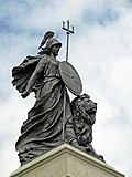 National Armada memorial (Britannia)
 -
 Naval War Memorial
 -
 The Parade, Barbican
 -
 The Mayflower Steps Memorial
 -
 Saltram House


Notes
- ↑ Otter, R. A. (1994). "The Tamar Valley and Plymouth". Civil Engineering Heritage: Southern England. Thomas Telford. pp. 48. ISBN 0727719718. http://books.google.com/?id=HG-l2kpKPFUC&printsec=frontcover#PPA48,M1. Retrieved 2008-07-08.
- ↑ 2.0 2.1 Gould, Jeremy (March 2007). Architecture and the Plan for Plymouth: The Legacy of a British City. Architectural Review.
- ↑ 3.0 3.1 3.2 3.3 3.4 3.5 3.6 Gill, Crispin (1993). Plymouth. A New History. Devon Books. pp. 262–267. ISBN 0-86114-882-7.
- ↑ 4.0 4.1 "Parks and open spaces". Plymouth City Council. http://www.plymouth.gov.uk/parksandopenspaces. Retrieved 2008-09-01.
- ↑ "Central Park". Plymouth City Council. http://www.plymouth.gov.uk/centralpark. Retrieved 2009-02-17.
- ↑ Report and Transactions. 9. Devonshire Association for the Advancement of Science. 1877. pp. 426. http://books.google.com/?id=Q1QDAAAAMAAJ&q=Plymouth+Hoe+limestone&dq=Plymouth+Hoe+limestone. Retrieved 2008-07-11.
- ↑ "Coast Walks: Point 5 - Smeaton's Tower". The BBC. 2008-01-25. http://www.bbc.co.uk/devon/content/articles/2005/06/07/coast05walks_stage5_feature.shtml. Retrieved 2008-07-05.
- ↑ Cunliffe, Barry (2004). "Britain and the Continent:Networks of Interaction". in Malcolm Todd. A Companion to Roman Britain. Blackwell Publishing. pp. 3. ISBN 0631218238. http://books.google.com/?id=SYMFtWb-DYQC&printsec=frontcover. Retrieved 2008-06-23.
- ↑ 9.0 9.1 9.2 9.3 "The early history of Plymouth". Plymouth City Council. http://www.plymouth.gov.uk/localhistory. Retrieved 2008-07-19.
- ↑ Eilert Ekwall (1981). The Concise Oxford Dictionary of English Place-names. Oxford [Eng.]: Oxford University Press. pp. 369. ISBN 0 19 869103 3.
- ↑ Plymouth data.info attributes this statement to Crispin Gill.
- ↑ Sumption, Jonathan (1999). "Sluys and Tournai: The War of the Alberts". The Hundred Years War: Trial by Battle. University of Pennsylvania Press. pp. 347. ISBN 0812216555. http://books.google.com/?id=V6vghfDY7loC&printsec=frontcover#PRA2-PA347,M1. Retrieved 2008-06-29.
- ↑ "Devon timeline". Devon County Council. http://www.devon.gov.uk/localstudies/100323/1.html. Retrieved 2008-06-29.
- ↑ Jewitt, Llewellynn Frederick (1873). A history of Plymouth. University of Oxford. pp. 648.
- ↑ 15.0 15.1 "Slave Ships in Plymouth". Plymouth City Council. http://www.plymouth.gov.uk/homepage/leisureandtourism/libraries/whatsinyourlibrary/lns/slaveryandabolition/slavetradetriangle/plymouthslaveships.htm. Retrieved 2008-07-26.
- ↑ "Adventurers and Slavers". The National Archives. http://www.nationalarchives.gov.uk/pathways/blackhistory/early_times/adventurers.htm. Retrieved 2007-10-13.
- ↑ 17.0 17.1 "Sir Francis Drake". The BBC. http://www.bbc.co.uk/devon/discovering/famous/francis_drake.shtml. Retrieved 2008-07-24.
- ↑ Kellogg, William O. (2003). American History the Easy Way: The Easy Way (3rd ed.). Hauppauge, N.Y.: Barron's. pp. 20. ISBN 0764119737. http://books.google.com/?id=mKhRlkY278QC&printsec=frontcover#PPA20,M1. Retrieved 2008-11-14.
- ↑ 19.0 19.1 19.2 "Siege". The BBC. 2003-01-06. http://www.bbc.co.uk/insideout/southwest/series2/siege_civil_war_plymouth.shtml. Retrieved 2008-07-06.
- ↑ 20.0 20.1 "Coast Walks: Point 3 - The Citadel". The BBC. 2008-01-25. http://www.bbc.co.uk/devon/content/articles/2005/06/07/coast05walks_stage3_feature.shtml. Retrieved 2008-07-05.
- ↑ "Brief history of Plymouth". Plymouth City Council. http://www.plymouth.gov.uk/homepage/creativityandculture/heritageandhistory/lns/plymouthhistory.htm. Retrieved 2008-07-20.
- ↑ Carrington, Henry Edmund (1828). The Plymouth and Devonport guide. University of Oxford. pp. 1. http://books.google.com/?id=Ve4GAAAAQAAJ&printsec=titlepage. Retrieved 2008-07-05.
- ↑ "Cargo and Trade, Ocean Landing Pier" (PDF). Plymouth City Museum and Art Gallery. http://www.plymouth.gov.uk/millbay_docks_20-24.pdf. Retrieved 2008-07-26.
- ↑ 24.0 24.1 "Plymouth, John Foulston". Plymouth Data. http://www.plymouthdata.info/PP-Foulston.htm. Retrieved 2008-05-16.
- ↑ http://www.plymouthdata.info/Breakwater.htm
- ↑ http://www.plymouthdata.info/Palmerstons%20Forts.htm
- ↑ "Imports". Plymouth Data. 2005-08-30. http://www.plymouthdata.info/Imports.htm. Retrieved 2008-07-24.
- ↑ 28.0 28.1 "Characteristics of the City of Plymouth (Historical and industrial legacy)". Plymouth City Council. http://www.plymouth.gov.uk/characteristicsplymouth. Retrieved 2008-07-24.
- ↑ 29.0 29.1 http://www.plymouthdata.info/Great%20War.htm
- ↑ http://www.cyber-heritage.co.uk/waiting/day.htm
- ↑ Gill, Crispin (1993). Plymouth. A New History. Devon Books. pp. 259–262. ISBN 0-86114-882-7.
- ↑ "Frosty response to church climb". BBC News. 2005-11-17. http://news.bbc.co.uk/1/hi/england/devon/4444690.stm. Retrieved 2008-11-22.
- ↑ 33.0 33.1 "HMNB Devonport". The Royal Navy. http://www.royalnavy.mod.uk/operations-and-support/establishments/naval-bases-and-air-stations/hmnb-devonport/. Retrieved 2009-10-27.
- ↑ 34.0 34.1 34.2 "Business and economy". Plymouth City Council. http://www.plymouth.gov.uk/businessandeconomy. Retrieved 2008-07-17.
- ↑ 35.0 35.1 Andrews, Robert (2004). The Rough Guide to Devon & Cornwall. Peter Hack, Kate Hughes, Bea Uhart (2 ed.). Rough Guides. pp. 139. ISBN 9781843533122. http://books.google.com/?id=Yoll2mMLp1QC&printsec=frontcover. Retrieved 2009-07-26.
- ↑ "Marine Sector". Plymouth City Council website. The University of Plymouth. http://www.plymouth.gov.uk/textonly/marinesector. Retrieved 2008-07-22.
- ↑ "University of Plymouth - an introduction". The University of Plymouth. http://www.plymouth.ac.uk/pages/view.asp?page=1060. Retrieved 2008-11-16.
- ↑ "Established BIDs". National BIDs Advisory Service. http://www.ukbids.org/BIDS/index.php. Retrieved 2008-02-16.
- ↑ "Point 6 - Tinside Pool". The BBC. 2008-01-25. http://www.bbc.co.uk/devon/content/articles/2005/06/07/coast05walks_stage6_feature.shtml. Retrieved 2008-11-16.
- ↑ 40.0 40.1 "A vision for Plymouth". Plymouth City Council. http://www.plymouth.gov.uk/vision#city_centre. Retrieved 2008-09-01.
- ↑ 41.0 41.1 "Controversy over £200m shops plan". BBC News. 2006-10-05. http://news.bbc.co.uk/1/hi/england/devon/5402112.stm. Retrieved 2007-10-13.
- ↑ "Changing perceptions of Plymouth". BBC News. 2006-10-05. http://news.bbc.co.uk/1/hi/england/devon/5385206.stm. Retrieved 2008-11-15.
- ↑ 43.0 43.1 43.2 "Places of worship". Plymouth City Council. http://www.plymouth.gov.uk/homepage/communityandliving/placesofworship.htm. Retrieved 2008-09-02.
- ↑ "Plymouth Cathedral 1858 - 2008: 150th Anniversary Celebrations". Roman Catholic Diocese of Plymouth. http://www.plymouth-diocese.org.uk/index.php?q=node/494. Retrieved 2008-09-02.
- ↑ "Christian". Plymouth City Council. http://www.plymouth.gov.uk/homepage/communityandliving/placesofworship/christian.htm. Retrieved 2008-09-02.
- ↑ "The Exclusive Brethren History". The BBC. 2004-02-04. http://www.bbc.co.uk/religion/religions/christianity/subdivisions/exclusivebrethren_2.shtml. Retrieved 2008-07-13.
- ↑ "Synagogue, Catherine Street, Plymouth". English Heritage. http://www.imagesofengland.org.uk/Details/Default.aspx?id=473229. Retrieved 2008-11-22.
- ↑ "Other faiths, religions and beliefs". Plymouth City Council. http://www.plymouth.gov.uk/homepage/communityandliving/placesofworship/otherfaiths.htm. Retrieved 2008-09-02.
- ↑ "Plymouth's Historic Barbican". The BBC. 2008-02-18. http://www.bbc.co.uk/devon/content/articles/2007/11/30/historic_barbican_feature.shtml. Retrieved 2008-11-16.
- ↑ "Point 8a - Mayflower Steps". The BBC. 2008-01-07. http://www.bbc.co.uk/devon/content/panoramas/point8a_mayflower_steps_360.shtml. Retrieved 2008-07-05.
- ↑ http://www.national-aquarium.co.uk/plymouth-attraction
- ↑ "Smeaton's Tower". Plymouth City Council. http://www.plymouth.gov.uk/homepage/creativityandculture/museums/museumsmeatonstower.htm. Retrieved 2008-09-03.
- ↑ http://www.landmarktrust.org.uk/otherOptions/crownhill.htm
- ↑ "War memorials". Plymouth City Council. http://www.plymouth.gov.uk/warmemorials. Retrieved 2008-09-02.
- ↑ "Saltram". The National Trust. http://www.nationaltrust.org.uk/main/w-vh/w-visits/w-findaplace/w-saltram/. Retrieved 2008-07-06.
- ↑ http://www.plymouth.gov.uk/homepage/leisureandtourism/tourismandvisitors/tourismcountryside.htm
- ↑ http://www.plymouth.ac.uk/pages/view.asp?page=14021
Further reading
- Dunning, Martin (2001). Around Plymouth. Frith Book.
- Gill, Crispin (1993). Plymouth: A New History. Devon Books.
- Robinson, Chris (2004). Plymouth Then & Now. Plymouth Prints.
- Casley, Nicholas (1997). The Medieval Incorporation of Plymouth and a Survey of the Borough's Bounds. Old Plymouth Society.
- Carew, Richard (1555). The Survey of Cornwall. http://www.gutenberg.org/dirs/etext06/srvcr10.txt. N.B. Carew refers to Plymouth Hoe as "the Hawe at Plymmouth"
- Abercrombie, Patrick; James Watson, Laurence Stamp and Gilbert Robinson, (1944-04-27). A Plan for Plymouth. Underhill. http://books.google.com/?id=nAYcAAAAIAAJ. N.B. the publication carries the date 1943, which is incorrect according to The Encyclopaedia of Plymouth History
Outside links
| Cities in the United Kingdom |
|---|
|
Aberdeen • Armagh • Bangor (Caernarfonshire) • Bangor (County Down) • Bath • Belfast • Birmingham • Bradford • Brighton and Hove • Bristol • Cambridge • Canterbury • Cardiff • Carlisle • Chelmsford • Chester • Chichester • Colchester • Coventry • Derby • Doncaster • Dundee • Dunfermline • Durham • Ely • Edinburgh • Exeter • Glasgow • Gloucester • Hereford • Inverness • Kingston upon Hull • Lancaster • Leeds • Leicester • Lichfield • Lincoln • Lisburn • Liverpool • London • Londonderry • Manchester • Milton Keynes • Newcastle upon Tyne • Newport • Newry • Norwich • Nottingham • Oxford • Perth • Peterborough • Plymouth • Portsmouth • Preston • Ripon • Rochester • Salford • Salisbury • Sheffield • Southampton • St Albans • St Asaph • St David's • Southend-on-Sea • Stirling • Stoke-on-Trent • Sunderland • Swansea • Truro • Wakefield • Wells • Westminster • Winchester • Wolverhampton • Worcester • Wrexham • York |