Leeds: Difference between revisions
| (2 intermediate revisions by 2 users not shown) | |||
| Line 24: | Line 24: | ||
The central area of Leeds is on the [[River Aire]] in a narrow section of the Aire Valley by the eastern foothills of the [[Pennines]]. The city centre lies at about 206 feet above sea level, while the landscape around the city rises in the west towards [[Ilkley Moor]] and falls further down the valleys of the Aire and the Wharfe. Leeds has grown into a continuous conurbation encompassing to Pudsey, Bramley, Horsforth, Alwoodley, Seacroft, Middleton and Morley.<ref name=UAmap>{{Cite web|url=http://www.statistics.gov.uk/downloads/census2001/ks_urban_north_part_8.pdf|format=PDF| title=Census 2001:Key Statistics for urban areas in the North; Map 6|authorlink=Office for National Statistics|publisher=statistics.gov.uk|accessdate=2009-09-27|year=2001|author=Office for National Statistics|work=United Kingdom Census 2001}}</ref> | The central area of Leeds is on the [[River Aire]] in a narrow section of the Aire Valley by the eastern foothills of the [[Pennines]]. The city centre lies at about 206 feet above sea level, while the landscape around the city rises in the west towards [[Ilkley Moor]] and falls further down the valleys of the Aire and the Wharfe. Leeds has grown into a continuous conurbation encompassing to Pudsey, Bramley, Horsforth, Alwoodley, Seacroft, Middleton and Morley.<ref name=UAmap>{{Cite web|url=http://www.statistics.gov.uk/downloads/census2001/ks_urban_north_part_8.pdf|format=PDF| title=Census 2001:Key Statistics for urban areas in the North; Map 6|authorlink=Office for National Statistics|publisher=statistics.gov.uk|accessdate=2009-09-27|year=2001|author=Office for National Statistics|work=United Kingdom Census 2001}}</ref> | ||
The city centre is less than twenty miles | The city centre is less than twenty miles from the [[Yorkshire Dales]] National Park,<ref>{{cite web|url=http://www.yorkshire-forward.com/our-wonderful-region/our-cities/Leeds-the-facts |title=Leeds – the facts|publisher=Yorkshire Forward Government agency |date= |accessdate=2009-01-22}}</ref> which offers some of the most spectacular scenery and countryside in the United Kingdom.<ref>{{cite web|url=http://www.visitbritain.co.uk/destinations/England/englands-north-country/Yorkshire-Dales.aspx |title=Leeds – The Yorkshire Dales|publisher=Visit Britain (National UK Tourist Agency) |date= |accessdate=2009-01-22}}</ref> | ||
Parts of Leeds even into the city centre lie on coal deposits and coal mining has been an important industry in the West Riding. | Parts of Leeds even into the city centre lie on coal deposits and coal mining has been an important industry in the West Riding. | ||
Leeds city centre is contained within the Leeds Inner Ring Road, formed from parts of the A58, A61 , A64, A643 road and the M621 motorway. Briggate, the principal north-south shopping street, is pedestrianised and Queen Victoria Street, a part of the Victoria Quarter, is enclosed under a glass roof. Millennium Square is a significant urban focal point. In this area ae found the prime retail and professional sites. | Leeds city centre is contained within the Leeds Inner Ring Road, formed from parts of the A58, A61, A64, A643 road and the M621 motorway. Briggate, the principal north-south shopping street, is pedestrianised and Queen Victoria Street, a part of the Victoria Quarter, is enclosed under a glass roof. Millennium Square is a significant urban focal point. In this area ae found the prime retail and professional sites. | ||
An inhabitant of Leeds is locally known as a ''Loiner'', a word of uncertain origin.<ref name=loiner>{{cite web|url=http://www.bbc.co.uk/leeds/content/articles/2005/01/06/voices2005_loiner_feature.shtml |title=Loiners of the world unite! | publisher=BBC | date=2005-08-22 | accessdate=2009-09-27}}</ref> | An inhabitant of Leeds is locally known as a ''Loiner'', a word of uncertain origin.<ref name=loiner>{{cite web|url=http://www.bbc.co.uk/leeds/content/articles/2005/01/06/voices2005_loiner_feature.shtml |title=Loiners of the world unite! | publisher=BBC | date=2005-08-22 | accessdate=2009-09-27}}</ref> | ||
| Line 156: | Line 156: | ||
* {{Cite book | title=A History of Modern Leeds | first=Derek | last= Fraser | publisher=Manchester University Press | year=1982 | isbn=9780719007811}} | * {{Cite book | title=A History of Modern Leeds | first=Derek | last= Fraser | publisher=Manchester University Press | year=1982 | isbn=9780719007811}} | ||
*{{Cite book | last=Unsworth and Stillwell | year=2004 | title=Twenty-First Century Leeds: Geographies of a Regional City | publisher= Leeds University Press | location=Leeds | isbn=0853162425|ref=harv }} | *{{Cite book | last=Unsworth and Stillwell | year=2004 | title=Twenty-First Century Leeds: Geographies of a Regional City | publisher= Leeds University Press | location=Leeds | isbn=0853162425|ref=harv }} | ||
{{Cities in the United Kingdom}} | |||
Latest revision as of 10:50, 30 March 2016
| Leeds | |
| Yorkshire West Riding | |
|---|---|
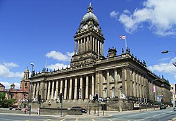 Leeds Town Hall | |
| Location | |
| Location: | 53°47’59"N, 1°32’57"W |
| Data | |
| Population: | 443,247 (2001) |
| Post town: | Leeds |
| Postcode: | LS |
| Local Government | |
| Council: | Leeds |
Leeds is a city in the West Riding of Yorkshire. It is Yorkshire's biggest city and its prime commercial centre. Leeds is the largest centre for business, legal, and financial services in Britain outside London and according to the recent Office for National Statistics estimates, it is the fastest growing city in the United Kingdom.
The city
Leeds can trace its recorded history to the fifth century. In the 17th and 18th centuries Leeds became a major centre for the production and trading of wool. Then, during the Industrial Revolution, Leeds developed into a major industrial centre; wool was still the dominant industry but flax, engineering, iron foundries, printing and other industries were important. In the process, what had in the 16th century been a compact Airedale market town, expanded and absorbed the surrounding villages to become by the opening of the 20th century a populous urban centre, and now a major regional city.
The city's diverse array of buildings, monuments and open spaces reflects both its industrial past and its many current roles. The multicultural nature of the city is evidenced in the range of religious buildings and cultural festivals present. The city is a major centre of higher education, being the seat of the internationally acclaimed University of Leeds as well as Leeds Metropolitan University and Leeds Trinity University College. The student population has stimulated growth of the nightlife in the city and there are ample facilities for sporting and cultural activities, including classical and popular music festivals, and a varied collection of museums.
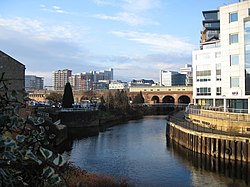
The central area of Leeds is on the River Aire in a narrow section of the Aire Valley by the eastern foothills of the Pennines. The city centre lies at about 206 feet above sea level, while the landscape around the city rises in the west towards Ilkley Moor and falls further down the valleys of the Aire and the Wharfe. Leeds has grown into a continuous conurbation encompassing to Pudsey, Bramley, Horsforth, Alwoodley, Seacroft, Middleton and Morley.[1]
The city centre is less than twenty miles from the Yorkshire Dales National Park,[2] which offers some of the most spectacular scenery and countryside in the United Kingdom.[3]
Parts of Leeds even into the city centre lie on coal deposits and coal mining has been an important industry in the West Riding.
Leeds city centre is contained within the Leeds Inner Ring Road, formed from parts of the A58, A61, A64, A643 road and the M621 motorway. Briggate, the principal north-south shopping street, is pedestrianised and Queen Victoria Street, a part of the Victoria Quarter, is enclosed under a glass roof. Millennium Square is a significant urban focal point. In this area ae found the prime retail and professional sites.
An inhabitant of Leeds is locally known as a Loiner, a word of uncertain origin.[4]
History
Name of the town
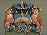
The name Leeds derives from "Loidis", the name given to a forest covering most of the kingdom of Elmet, a Welsh kingdom which existed in the Pennine region during the 5th century into the early 7th century.[5] In the fourteenth chapter of his Ecclesiastical History of the English People, Bede refers to an altar surviving from a church erected by Edwin of Northumbria, saying that it is located in ...regione quae vocatur Loidis ("the region known as Loidis").
Economic development
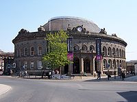
Leeds developed as a market town in the Middle Ages as part of the local agricultural economy. Prior to the Industrial Revolution it had become a co-ordination centre for the making of woollen cloth; with white broadcloth being traded at the Leeds White Cloth Hall.[6] Leeds was handling one sixth of England's export trade in 1770. Growth, initially in textiles, was accelerated by the building of the Aire and Calder Navigation in 1699 and the Leeds and Liverpool Canal in 1816. The railway network constructed around Leeds, starting with the Leeds and Selby Railway in 1834, provided improved communications with national markets and, significantly for its development, an east-west connection with Manchester and the ports of Liverpool and Hull giving improved access to international markets.[7] Alongside technological advances and industrial expansion, Leeds retained an interest in trading in agricultural commodities, with the Corn Exchange opening in 1864.
Marshall's Mill was one of the first of the many factories that were to be constructed in Leeds from around 1790. In the early years the most significant of the factories were woollen finishing and flax mills; diversifying by 1914 to printing, engineering, chemicals and clothing manufacture. Decline in manufacturing during the 1930s was temporarily reversed by a switch to producing military uniforms and munitions during World War II. However, by the 1970s the clothing industry was in irreversible decline, facing cheap foreign competition.[8] The contemporary economy of Leeds has developed from the decay of the post-industrial era to become a telephone banking centre, connected to the electronic infrastructure of the modern global economy. There has been growth in the corporate and legal sectors[9] and increased local affluence has led to an expanding retail sector, including the luxury goods market.[10]
Suburban growth
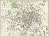
In 1801, 42% of the population of Leeds lived outside the township, in the wider borough. Cholera outbreaks in 1832 and 1849 caused the borough authorities to address the problems of drainage, sanitation and water supply. Water was originally pumped from the River Wharfe, but by 1860 it was too heavily polluted to be usable. Following the Leeds Waterworks Act of 1867 three reservoirs were built at Lindley Wood, Swinsty and Fewston, to the north of Leeds. Residential growth occurred in Holbeck and Hunslet from 1801 to 1851, but, as these townships became industrialised new areas were favoured for middle class housing. Land to the south of the river was henceforth developed, primarily for industry and secondarily for back-to-back workers' dwellings. The Leeds Improvement Act 1866 sought to improve the quality of working class housing by restricting the number of homes that could be built in a single terrace.[11] Holbeck and Leeds formed a continuous built-up area by 1858, with Hunslet nearly meeting them. In the latter half of the nineteenth century, population growth in Hunslet, Armley and Wortley outstripped that of Leeds itself. When pollution became a problem, the wealthier residents left the small industrial conurbation to live in the northerly villages of Headingley, Potternewton and Chapel Allerton; this led to a 50% increase in the population of Headingley and Burley from 1851 to 1861. The middle class flight from the industrial areas also led to development beyond the borough at Roundhay and Adel.[12] The introduction of the electric tramway led to intensification of development in Headingley and Potternewton and expansion outside the borough into Roundhay.
Two private gas supply companies were taken over by the corporation in 1870 and this new municipal supply was used to provide street lighting and cheaper gas to homes. From the early 1880s the Yorkshire House-to-House Electricity Company supplied electricity to Leeds until it was also purchased by Leeds Corporation and became a municipal supply.
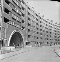
Slum clearance and rebuilding began in Leeds in the Inter-war period when over 18,000 houses were built by the council on 24 estates in places like Cross Gates, Middleton, Gipton, Belle Isle and Halton Moor. The slums of Quarry Hill were replaced by the innovative Quarry Hill flats, which were demolished in 1975. Another 36,000 houses were built by private sector builders, creating the suburbs of Gledhow, Moortown, Alwoodley, Roundhay, Colton, Whitkirk, Oakwood, Weetwood and Adel. After 1949 a further 30,000 sub-standard houses were demolished by the council to be replaced by a total of 151 medium-rise and high-rise blocks of council flats in estates like Seacroft, Armley Heights, Tinshill and Brackenwood.[13]
Recently, Leeds has seen great local expenditure on regenerating the city, attracting in investments and flagship projects,[14] as found in Leeds city centre. Many buildings have already been built, boasting luxurious penthouse apartments,[15] just a stones throw from the city centre. Recently, the Skyscraper Project has been put on hold, due to the global recession and overall downturn in the housing market. The building works are still planned to go ahead, despite very little recent change.
Economy
Leeds has a diverse economy with employment in the service sector now far exceeding that in the traditional manufacturing industries. In 2002, 401,000 employees were registered in the Leeds district. Of these 24.7% were in public administration, education and health, 23.9% were in banking finance and insurance and 21.4% were in distribution, hotels and restaurants. It is in the banking, finance and insurance sectors that Leeds differs most from the financial structure of the region and the nation. The city is the location of one of the largest financial centres in England outside London.[16][17][18][19][20][21] Tertiary industries such as retail, call centres, offices and media have contributed to a high rate of economic growth. The city also hosts the only subsidiary office of the Bank of England in the United Kingdom. In 2006 GVA for city was recorded at £16.3 billion,[22] with the entire Leeds City Region generating an economy of £46 billion.[23]
The extensive retail area of Leeds is identified as the principal regional shopping centre for the whole of the Yorkshire and the Humber region and approximately 3.2 million people live within its catchment area.[24] There are a number of indoor shopping centres in the middle of the city, including the Merrion Centre, Leeds|Merrion Centre, Leeds Shopping Plaza, St John's Centre, Headrow Centre, the Victoria Quarter, The Light and the Corn Exchange. In total there are approximately 1,000 retail stores, with a combined floorspace of 2,264,100 square feet.[24] Of the 40,000 people who work in retailing in Leeds 75% work in places which are not located in the city centre. There are additional shopping centres located in the many villages that became part of the county borough and in the towns that were incorporated in the City of Leeds in 1974.
Office developments, also traditionally located in the inner area, have expanded south of the River Aire and total 11,000,000 square feet of space.[24] In the period from 1999 to 2008 £2.500,000,000 of property development was undertaken in central Leeds; of which £711 million has been offices, £265 million retail, £389 million leisure and £794 million housing. Manufacturing and distribution uses accounts for £26 million of new property development in the period. There are 130,100 jobs in the city centre, accounting for 31% of all jobs in the wider district. In 2007, 47,500 jobs were in finance and business, 42,300 in public services, and 19,500 in retail and distribution. 43% of finance sector jobs in the district are contained in Leeds city centre and 44% of those employed in the city centre live more than five miles away.[24]
Churches
The majority of people in Leeds identify themselves as Christian. Leeds is part of the Diocese of Ripon and Leeds in the Church of England and although the Cathedral is in Ripon, the Bishop's residence has been in Leeds since 2008.
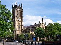
The most important Anglican church is the Leeds Parish Church.
Leeds has a Roman Catholic cathedral. Many other Christian denominations and new religious movements are established in Leeds, including Assembly of God, Baptist, Community of Christ, Greek Orthodox, Jesus Army, Lutherans, Methodists, Church of the Nazarene, Newfrontiers network, Pentecostal, The Salvation Army, Seventh-day Adventists, The Religious Society of Friends ("Quakers"), Unitarians, United Reformed Church, Vineyard, Wesleyan Church, an ecumenical Chinese church, and several independent churches.[25][26]
Other religions
Leeds has the third-largest Jewish community in the United Kingdom, after those of London and Manchester. The areas of Alwoodley and Moortown contain sizeable Jewish populations. There are eight active synagogues in Leeds.[27]
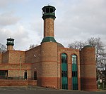
The proportion of Muslims in Leeds is average for the country.[28] Mosques can be found throughout the city, serving Muslim communities in Chapeltown, Harehills, Hyde Park and parts of Beeston. The largest mosque is the Leeds Grand Mosque in Hyde Park.
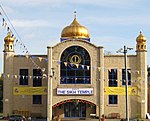
Sikhs are represented by gurudwaras spread across the city, the largest being in Chapeltown. There is also a colourful religious annual procession, called the Nagar Kirtan, into Millennium Square in the city centre around 13–14 April to celebrate Baisakhi, the Sikh New Year and the birth of the religion. It is estimated that around 3,000 Sikhs in Leeds take part in this annual event. The small Hindu community in Leeds has a temple at Hyde Park.[29]
There is a community of the Bahai faith in Leeds.[30]
Various Buddhist traditions are represented in Leeds.[31] The Buddhist community comes together to celebrate the major festival of Wesak in May.
Sights around the town
Natural landmarks in and around Leeds include such diverse sites as the gritstone outcrop of the Otley Chevin and the Fairburn Ings RSPB reserve.
The city's maintains parks at Roundhay and Temple Newsam, owned and maintained by the council for the benefit of local people. Other open spaces in the city centre are Millennium Square, Leeds City Square, Park Square and Victoria Gardens. This last is the site of the city's war memorial. There are 42 other war memorials in the suburbs, towns and villages in the district.[32]
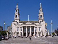
The built environment embraces edifices of civic pride like Morley Town Hall and the trio of buildings in Leeds, Leeds Town Hall, The Corn Exchange and Leeds City Museum by the architect Cuthbert Brodrick. The two startlingly white buildings on the Leeds skyline are the Parkinson building of Leeds University and the Civic Hall, with golden owls adorning the tops of its twin spires.[33] Armley Mills, Tower Works, with its campanile-inspired towers, and the Egyptian-style Temple Works hark back to the city's industrial past, while the site and ruins of Kirkstall Abbey display the beauty and grandeur of Cistercian architecture.
Notable churches are Leeds Parish Church, St George's Church and Leeds Cathedral (RC), in the city centre, and the Church of St John the Baptist, Adel and Bardsey, West Riding of Yorkshire|Bardsey Parish Church in quieter locations.
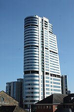
The 360-foot tower of Bridgewater Place, also known as The Dalek, is part of a major office and residential development and the region's tallest building; it can be seen for miles around.[34] Among other tower blocks, the 37-storey Sky Plaza to the north of the city centre stands on higher ground so that its 345 feet is higher than Bridgewater Place. With 37 floors it is reported to be the tallest student residential building in the world.[35]
Headingley Stadium (cricket and rugby) and Elland Road (football) are well known to sports enthusiasts.

Culture
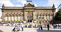
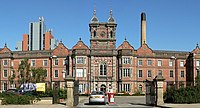
- Leeds City Museum opened in 2008[36] in Millennium Square.
- Abbey House Museum', housed in the former gatehouse of Kirkstall Abbey, and includes walk-through Victorian streets and galleries describing the history of the abbey, childhood, and Victorian Leeds.
- Armley Mills Industrial Museum, housed in what was once the world's largest woollen mill,[37] and includes industrial machinery and railway locomotives. This museum also shows the first known moving pictures in the world which were taken in the city, by Louis Le Prince, of a Roundhay Garden Scene and of Leeds Bridge in 1888.
- Thwaite Mills Watermill Museum, a fully-restored 1820s water-powered mill on the River Aire to the east of the city centre.
- The Thackray Museum, on the history of medicine, featuring topics such as Victorian public health, pre-anaesthesia surgery, and safety in childbirth. It is housed in a former workhouse next to St James's hospital.
- The Royal Armouries Museum opened in 1996 in a dramatic modern building when this part of the national collection was transferred from the Tower of London.
- Leeds Art Gallery reopened in June 2007 after a major renovation, and houses important collections of traditional and contemporary British art.
Smaller museums include the University of Leeds Textile Archive (ULITA),[38] and the museum at Fulneck Moravian Settlement, while outside Leeds in satellite villages are the Otley Museum and Horsforth Village Museum,[39]
Sport

The city has teams representing all the major national sports.
- Yorkshire County Cricket Club has its home ground at Headingley in the north of the city.
- Leeds United is the city's main football club. The club was formed in 1919 and plays at the 40,000 capacity Elland Road stadium in Beeston. The team plays in The Championship, the second tier of English football.
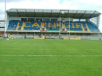
In rugby, Leeds Rhinos are the city's leading rugby league team. In 2009, Leeds Rhinos became first club to be Super League champions three seasons running, giving them their fourth Super League title.[40] They play their home games at the Headingley Carnegie Stadium. Other rugby clubs include Hunslet Hawks (at the John Charles Centre for Sport), Bramley Buffaloes and Leeds Akkies.
Leeds Carnegie, formerly known as Leeds Tykes, are the foremost rugby union team in Leeds, an also play at Headingley Carnegie Stadium.
Outside links
- 'Leeds Initiative' Leeds Initiative city partnership.
- Leodis Leeds Library & Information Service photograph archive.
- VR Leeds Leeds 360º Virtual Tour.
- 'Leeds Chamber of Commerce & Industry' Leeds Chamber of Commerce & Industry
- My Life in Leeds My Life in Leeds
- GENUKI's West Riding of Yorkshire resource index
- GENUKI map of West Riding parishes
References
- ↑ Office for National Statistics (2001). "Census 2001:Key Statistics for urban areas in the North; Map 6" (PDF). United Kingdom Census 2001. statistics.gov.uk. http://www.statistics.gov.uk/downloads/census2001/ks_urban_north_part_8.pdf. Retrieved 2009-09-27.
- ↑ "Leeds – the facts". Yorkshire Forward Government agency. http://www.yorkshire-forward.com/our-wonderful-region/our-cities/Leeds-the-facts. Retrieved 2009-01-22.
- ↑ "Leeds – The Yorkshire Dales". Visit Britain (National UK Tourist Agency). http://www.visitbritain.co.uk/destinations/England/englands-north-country/Yorkshire-Dales.aspx. Retrieved 2009-01-22.
- ↑ "Loiners of the world unite!". BBC. 2005-08-22. http://www.bbc.co.uk/leeds/content/articles/2005/01/06/voices2005_loiner_feature.shtml. Retrieved 2009-09-27.
- ↑ Fletcher, J. S.. The Story of English Towns: Leeds. London: Society for Promoting Christian Knowledge. OCLC 221589888. http://www.archive.org/details/storyoftheenglis027638mbp. Retrieved 2009-07-22.
- ↑ S.A. Caunce (2003). "Houses as Museums: The Case of the Yorkshire Wool Textile Industry". Transactions of the RHS Royal Historical Society (Royal Historical Society) 13: 329–343.
- ↑ Russ Haywood (2007). "Britain's national railway network: fit for purpose in the 21st century?". Journal of Transport Geography (Elsevier) 15 (3): 198–216. doi:10.1016/j.jtrangeo.2006.02.015.
- ↑ Katrina Honeyman (2000). Well suited: a history of the Leeds clothing industry, 1850–1990. Oxford University Press. ISBN 0199202370.
- ↑ "Legal services: Law firms have solid local roots and global ambitions". Financial Times. 2008-03-11. http://www.ft.com/cms/s/77eaffe6-ef2a-11dc-8a17-0000779fd2ac.html. Retrieved 2009-09-26.
- ↑ Leeds, Live it, Love it. "Sectors: Retail". Marketing Leeds. http://www.leedsliveitloveit.com/retail. Retrieved 2009-09-26.
- ↑ "The Working Classes: Housing". Discovering Leeds. Leeds City Council. http://www.leodis.net/discovery/discovery.asp?page=2003218_676159084&topic=2003218_372249783&subsection=200342_125637234. Retrieved 2009-09-26.
- ↑ Fraser, Derek (1982). A History of Modern Leeds. Manchester University Press. ISBN 9780719007811.
- ↑ Unsworth and Stillwell, 2004
- ↑ "Light Shines on Leeds Skyscraper Bids". http://www.skyscrapernews.com. http://www.skyscrapernews.com/news.php?ref=565. Retrieved 2010-05-24.
- ↑ "City Living Leeds". http://www.one-uk.co.uk. http://one-uk.co.uk/index.php?id=52. Retrieved 2010-05-24.
- ↑ "Leeds leading the way". Yorkshire Evening Post. http://www.yorkshireeveningpost.co.uk/news/We39re-leading-the-way-in.2034867.jp. Retrieved 2009-01-25.
- ↑ "Leeds Financial Facts and Figures". http://www.leedsfinancialservices.org.uk/. http://www.leedsfinancialservices.org.uk/. Retrieved 2009-01-25.
- ↑ "Northern Star". FDI Magazine. http://www.fdimagazine.com/news/fullstory.php/aid/2512/Northern_star.html. Retrieved 2009-01-25.
- ↑ "Leeds Services". Financial Times. http://www.ft.com/cms/s/77eaffe6-ef2a-11dc-8a17-0000779fd2ac.html. Retrieved 2009-01-25.
- ↑ "Leeds Legal Review". Law Gazette. http://www.lawgazette.co.uk/features/ltbgtyorkshire-gritltbgt. Retrieved 2009-01-25.
- ↑ "Live the Leeds Lifestyle". Legal Week Magazine. http://www.legalweek.com/Articles/1146376/Live+the+Leeds+lifestyle.html. Retrieved 2009-01-25.
- ↑ http://www.statistics.gov.uk/pdfdir/gva1208.pdf
- ↑ http://locateinleeds.com/financial-services
- ↑ 24.0 24.1 24.2 24.3 "The City Centre". Leeds Economy Handbook. Leeds City Council. http://www.leeds.gov.uk/files/Internet2007/2009/22/13%20city%20centre.pdf. Retrieved 2009-09-27.
- ↑ Universities chaplaincy in Leeds. "Student Guide to Churches in Leeds". http://www.leeds.ac.uk/chaplaincy/events/worship/churches1.php. Retrieved 2007-12-06.
- ↑ Yahoo. "Churches in Leeds". http://uk.local.yahoo.com/West_Yorkshire/Leeds/Churches/uk100006150-s-26042.html. Retrieved 2007-12-07.
- ↑ "JCR-UK – Leeds Jewish Community and Synagogues". Jewishgen.org. http://www.jewishgen.org/jcr-uk/Leeds.htm. Retrieved 2008-10-14.
- ↑ Census Data
- ↑ "Leeds Hindu Mandir – Welcome". Leedsmandir.org.uk. http://www.leedsmandir.org.uk. Retrieved 2009-07-22.
- ↑ "Leeds". Bahai Community of the United Kingdom. http://www.bahai.org.uk/leeds/index.htm. Retrieved 2009-07-14.
- ↑ "Buddhist organisations in: Leeds/Bradford areas P2". Communigate.co.uk. http://www.communigate.co.uk/brad/leedsbuddhistgroup/page2.phtml. Retrieved 2008-10-14.
- ↑ "War memorials". Leeds City Council. http://www.leeds.gov.uk/Leisure_and_culture/Local_history_and_heritage/Memorial__maintenance.aspx. Retrieved 2009-11-06.
- ↑ "Leodis – a photographic archive of Leeds – Display". Leeds City Council. Leodis. http://www.leodis.net/display.aspx?resourceIdentifier=20031021_1594179&DISPLAY=FULL. Retrieved 2009-11-06.
- ↑ "Bridgewater Place, Leeds – Building #734". skyscrapernews.com. http://www.skyscrapernews.com/buildings.php?id=734. Retrieved 2009-11-05.
- ↑ "Worlds Tallest Student Block Completes In Leeds". Skyscraper.com. 26 June 2009. http://www.skyscrapernews.com/news.php?ref=2178. Retrieved 2009-11-06.
- ↑ "Leeds City Museum website". http://www.leeds.gov.uk/cityMuseum/.
- ↑ "Museum homepage, hosted on Leeds City Council website". http://www.leeds.gov.uk/armleymills/.
- ↑ "ULITA". University of Leeds International Textiles Archive. http://ulita.leeds.ac.uk/. Retrieved 2009-10-29.
- ↑ "Horsforth Village Museum". Culture 24. http://www.culture24.org.uk/yh000070. Retrieved 2009-10-29.
- ↑ "St Helens 10–18 Leeds Rhinos". BBC News. 2009-10-10. http://news.bbc.co.uk/sport1/hi/rugby_league/8290503.stm. Retrieved 2010-04-04.
Further reading
- Burt and Grady (1994). The Illustrated History of Leeds. Breedon Books. ISBN 1 873626 35 5.
- Fraser, Derek (1982). A History of Modern Leeds. Manchester University Press. ISBN 9780719007811.
- Unsworth and Stillwell (2004). Twenty-First Century Leeds: Geographies of a Regional City. Leeds: Leeds University Press. ISBN 0853162425.
| Cities in the United Kingdom |
|---|
|
Aberdeen • Armagh • Bangor (Caernarfonshire) • Bangor (County Down) • Bath • Belfast • Birmingham • Bradford • Brighton and Hove • Bristol • Cambridge • Canterbury • Cardiff • Carlisle • Chelmsford • Chester • Chichester • Colchester • Coventry • Derby • Doncaster • Dundee • Dunfermline • Durham • Ely • Edinburgh • Exeter • Glasgow • Gloucester • Hereford • Inverness • Kingston upon Hull • Lancaster • Leeds • Leicester • Lichfield • Lincoln • Lisburn • Liverpool • City of London • Londonderry • Manchester • Milton Keynes • Newcastle upon Tyne • Newport • Newry • Norwich • Nottingham • Oxford • Perth • Peterborough • Plymouth • Portsmouth • Preston • Ripon • Rochester • Salford • Salisbury • Sheffield • Southampton • St Albans • St Asaph • St David's • Southend-on-Sea • Stirling • Stoke-on-Trent • Sunderland • Swansea • Truro • Wakefield • Wells • Westminster • Winchester • Wolverhampton • Worcester • Wrexham • York |