Daventry
| Daventry | |
| Northamptonshire | |
|---|---|
 High Street, Daventry | |
| Location | |
| Grid reference: | SP5762 |
| Location: | 52°15’36"N, 1°9’36"W |
| Data | |
| Population: | 25,026 (2011) |
| Post town: | Daventry |
| Postcode: | NN11 |
| Dialling code: | 01327 |
| Local Government | |
| Council: | West Northamptonshire |
| Parliamentary constituency: |
Daventry |
Daventry is a sizable market town in western Northamptonshire, with a population of 25,026 at the 2011 census.
The town comprises a historic market centre surrounded by much modern housing and light industrial development. On the edge of the town centre is the popular Daventry Country Park and reservoir, just east of the A425.
A street market is held every Tuesday and Friday in High Street, although its original site was on the aptly named Market Square. On the first Saturday of each month a farmers' market is held in High Street.
Name
The town's name is generally pronounced with a short a, as dævəntri, though formerly it was ˈdeɪntri. This older pronunciation used by locals, 'Daintree,' has latterly become less common.[1][2] Shakespeare calls it "Daintree" in Henry VI, Part I.
It is believed that the name of Daventry is from the ancient British language equivalent to the Welsh words dwy-afon-tre, suggesting "town of two rivers", which describes its geographical situation between the nearby sources of the River Leam, which flows west, and the River Nene which flows east.[3]
Another idea believed locally is that the name refers to a "Dane tree"; local tradition has it that Danish settlers planted an oak tree on the summit of Borough Hill to mark the centre of England. This part of the town's history is reflected in the town's seal of a Viking/ Saxon axeman and an oak tree.
The town appears as Dauentre on the Christopher Saxton map of 1637.
The town

There are 74 buildings or groups of buildings[4] in the centre of Daventry, led by the Church of Holy Cross at grade I. Grade II* buildings include the Saracen's Head (now Wetherspoons [5]), the Moot Hall (see below), the Wheatsheaf (now a residential home), 27, 29, 36, 57, 59 High Street and 2, 20, and 22 Sheaf Street. Grade II listed buildings include several in Market Place, Church Walk, New Street, High Street, Sheaf Street and the United Reformed Church, the Burton Memorial, Danetre Hospital Offices (a former workhouse) and Middlemore Farmhouse (now a pub).
The town once had a railway station on the former London and North Western Railway branch-line from Weedon to Leamington Spa, but it was closed in September 1958. The local weekly newspaper, the Daventry Express, is nicknamed 'The Gusher', after the steam engine that used to serve the town.
Geography
The town is 14 miles west of the county town, Northampton and 10 miles southeast of Rugby in Warwickshire, and 16 miles north-northeast of Banbury.
The town sits at around 440–520 feet above sea level and is surrounded to the south and east by hills topping out at 700 feet. The county's highest point, which is Arbury Hill, is a little to the south of Daventy.
Daventry sits by the watershed between basins of the River Leam, which flows west to the River Avon and to the west coast, and the River Nene, which flows east to the Wash. There is no river in the town itself. Nearby the Grand Union Canal that swings from Watford Gap into the western Midlands through the 2,042-yard long Braunston Tunnel around the north of the town. To the north east is the Daventry Reservoir and country park.
Watford Gap is about 4 miles to the northeast of the town. Through this gap pass the A5 (the course of Roman Watling Street), the Grand Union Canal, the West Coast Main Line railway, the Northampton Loop Line and most recently the M1 motorway.
Daventry is near the M1 motorway with access to two junctions: 18 to the northeast and 16 to the southeast of the town.
Parish church

Holy Cross is the parish church of Daventry, the only Church of England church in the town and is the only 18th-century town church in Northamptonshire.[6]
Holy Cross was built between 1752 and 1758 by David Horne and is constructed of the local ironstone. The western elevation is broad with large pilasters at the angles and the angles of the centre bay. The entrance porch was added in 1951. The tower rises from the centre bay and is square ending with an obelisk spire rising above. Inside, the church has three wooden galleried aisles, to the north, south and west elevations. The pulpit is decorated with marquetry and fretwork and has a staircase with twisted balusters. Above the altar at the eastern elevation is a three-bayed Venetian stained glass window. There is heraldic glass in the two upper west windows. There are C18 and C19 grey and white marble wall monuments in the chancel, finely carved gallery monument of 1707, 1800 gallery monument by Cox, and 1741 by B Palmer.[7]
The Heritage at Risk Register for 2012[8] states that "Holy Cross is clearly well cared for and well maintained. However, some high level ironstone blocks and limestone balusters have weathered badly. Parapet and balustrade masonry is of particular concern. Some masonry fragments have already fallen. A grant was offered in December 2011" .. and, with locally raised funds and a large anonymous donation, work commenced in May 2013.
History
Early history
On Borough Hill (653 feet) that overlooks the town, remains have been found of an Iron Age hill fort; one of the largest found in Britain. Remains have also been found on the hill of a Roman villa.
Daventry began as a small Anglo-Saxon village. By the 12th century had become home to a priory, dissolved under Henry VIII. In 1255 Daventry was granted a charter to become a market town. In 1576 Queen Elizabeth I granted Daventry borough status.
The town was mentioned by William Shakespeare in Henry VI, Part I, which refers to "the red-nosed innkeeper of Daintree".
Civil War
During the Civil War, the army of King Charles I stayed at Daventry in 1645 after storming the Parliamentary garrison at Leicester and on its way to relieve the siege of Oxford. The Royalist army, made up of 5,000 foot and as many horse, camped on Borough Hill (then spelt Burrow Hill) while Charles went hunting in the nearby forests.
According to local legend, it was during his stay at the Wheatsheaf Inn in Daventry that Charles was twice visited by the ghost of his former adviser and friend, Thomas Wentworth, 1st Earl of Strafford, who advised him to keep heading north and warned him that he would not win through force of arms.
Parliament's newly formed New Model Army, led by Sir Thomas Fairfax, was marching north from besieging Oxford after being instructed to engage the king's main army. Fairfax's leading detachments of horse clashed with Royalist outposts near Daventry on the 12th of June, alerting the king to the presence of the Parliamentary army. The Royalists made for their reinforcements at Newark-on-Trent but after reaching Market Harborough turned to fight, which resulted in the decisive Battle of Naseby. The village of Naseby is approximately 14 miles northeast of Daventry.
Decline 1840–1960

The main roads from London to Holyhead passed through Daventry and the town for centuries flourished as a coaching town. There were many coaching inns in the town of which only the Dun Cow, Saracens Head and the Coach and Horses remain as inns.
When the London and Birmingham Railway was opened in 1838 the coaching trade slumped and the town entered a long period of stagnation and decline which lasted for over a century. The Industrial Revolution largely passed Daventry by owing to its poor transport links. The canals passed around Daventry, although the Grand Junction Canal (now Grand Union) passed a few miles north. A branch from the Grand Union Canal to Daventry was proposed but was never built.[9]
The railways did not connect Daventry until quite late in the 19th century. Although the town was only a few miles from the main London to Birmingham line it took until 1888 before a branch line was built from Weedon to Daventry. In 1895 the line was extended to Leamington Spa, although being only a branch line this failed to spur much growth. Daventry's economy remained largely rural, with shoemaking as the main industry.
The Moot Hall

The Moot Hall stands on the north side of the market square next to the Plume of Feathers inn. It was built in 1769[6] from ironstone and has had various uses over the years, including town council building, a women's prison, the mayor's parlour, town museum and tourist information office, an Indian restaurant and an antiques centre, is of two and a half storeys, and has three bays of windows. The main entrance and its porch is on the western elevation where the building is connected to a house built in 1806. The original staircase from the Moot Hall is now installed at Welton Manor House.[6]
Broadcasting station

In 1925 the newly created BBC constructed a broadcasting station on Borough Hill[10] just outside the town. Daventry was chosen because it was the point of maximum contact with the land mass of southern Britain. From 1932 the BBC Empire Service (now the BBC World Service) was broadcast from there. The radio announcement of "Daventry calling" made Daventry well-known across the world. It was the BBC's use of the literal pronunciation in this call-sign that helped the widespread displacement of the historical pronunciation "Daintree" (ˈdeɪntri); that and the huge number of new residents settling in the town from the 1960s.
On the early morning of Tuesday 26 February 1935 the radio station at Daventry (Borough Hill) was used for the first-ever practical demonstration of radar, by its inventor Robert Watson-Watt and Arnold Frederic Wilkins, who used a radio receiver installed in a trailer at Stowe Nine Churches (just off the A5 about three miles south of Weedon Bec) to receive signals bounced off a metal-clad Handley Page Heyford bomber flying across the radio transmissions. The interference picked up from the aircraft allowed its approximate navigational position to be estimated.

The station closed in 1992 and only one of the radio masts now remains. A busy directional radio beacon (VOR), identifier "DTY", for aircraft is situated approximately 4 miles south of the town. The town also gives its name to the busy Daventry air traffic control sector.
75 Years to the day (26 February 2010) Teams from the Coventry Amateur Radio Society & The Northhampton Radio Club re-enacted the 'Daventry Experiment'. Signals from GB75RDF at Borough Hill, reflected from aircraft all of which were flown by radio hams, were detected in a receiving set housed in a replica Morrris van. The receiving station set up in the field that is the home to The Birth of RADAR memorial at Litchborough. The report of this to be found at http://www.andrewphotographic.co.uk/g8gmu9c.htm The team was led by Brian Leathley - Andrew G8GMU
Modern times
The modern growth of Daventry occurred from the 1960s onwards as part of a planned expansion of the town.
Daventry remained a small rural town until the 1950s; in 1950 it had a population of around 4,000. Real growth started in 1955 when the tapered roller bearing manufacturer Timken located a large factory in the town (the factory closed in 1993 although the distribution Centre stayed open until 2000).[11]
In the early 1960s, Daventry was designated as an 'overspill' to house people and industry moved from Birmingham; a planned expansion was carried out as part of an agreement with Birmingham City Council. The plan did not, however, live up to expectations. The target population was 36,000 by 1981, but actual growth was much slower than this; nevertheless, by 1981 the population had soared to 16,178 and by 2001 it was 22,367. More recently, a new wave of development has been proposed which could take the town's population to about 40,000 by 2021.[12]
In 2006, the outdoor pool, which had been built and funded by Daventry residents in the 1950s following the drowning of three children in the local reservoir, was closed due funding difficulties.[13] In 2007, Daventry began plans to modernise the town with a futuristic personal rapid transit system that would link outer estates to the town centre, and a canal arm with marina next to the former site of the outdoor pool.
In November 2012 it was announced by ITV studios that a series of the popular Channel 4 show "Come Dine With Me" will be filmed in Daventry and surrounding villages[14]
Local economy

Cummins have their largest UK plant at the town where they manufacture their largest diesel engines that are suitable for marine, railcar and generator set uses.
Owing to its good transport links, Daventry is now a warehousing and distribution centre. North of the town Daventry International Rail Freight Terminal (DIRFT) is a major terminal for freight interchange between road and rail. This is much closer to Rugby than Daventry, being situated just off junction 18 of the M1 (its original northern terminus in 1959 until 1964).
Due to the proximity to the M1, Ford opened up a large national spare parts distribution warehouse on the Royal Oak Industrial Estate. The 130-acre building took Taylor Woodrow a year to build at a cost of £2.25 million and was for many years considered the largest building in the United Kingdom.
A new national distribution centre was opened in 2004, run by DHL, for J D Wetherspoon on the Drayton Fields Industrial Estate, northwest of the town.
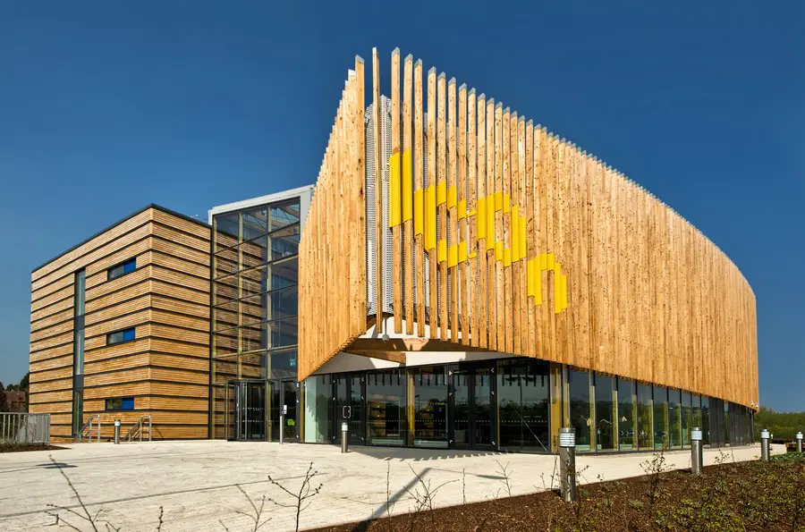
In 2011 a landmark building was opened in Eastern Way - the iCon. It provides conferencing and 55 supported units for businesses involved in low carbon construction and environmental technologies. It also includes a café, exhibition space and an auditorium for 300 people. Funding for the project came from the taxpayers' money doled out by various local and European bureaucracies. It is now operated by the University of Northampton.
Sport and leisure
- Football:
- Daventry United FC
- Daventry Town FC
Outside links
| ("Wikimedia Commons" has material about Daventry) |
- Daventry Town Council
- Daventry Express - local weekly newspaper
- Northamptonshire Communications Club - Borough Hill Radio History
References
- ↑ Vision of Britain
- ↑ House of Names
- ↑ Daventry
- ↑ British Listed Buildings
- ↑ Wetherspoons
- ↑ 6.0 6.1 6.2 The Buildings of England, Northamptonshire, by Nikolaus Pevsner, 2nd Edition revised by Bridget Cherry, p. 173. ISBN 0-14-071022-1
- ↑ British Listed Buildings citation
- ↑ [1], Heritage at Risk 2012 - see page 61.
- ↑ "Daventry Canal Association". History. Daventry. 2011. http://www.daventrycanal.org.uk/history.html. Retrieved 29 June 2011.
- ↑ www.bbceng.info/Books/dx-world/dx-calling-the-world-2008a.pdf.
- ↑ BBC news article
- ↑ West Northamptonshire Development Corporation Vision for Daventry
- ↑ "Outdoor pool shuts after 40 years". BBC News. 4 September 2006. http://news.bbc.co.uk/1/hi/england/northamptonshire/5311536.stm. "An outdoor swimming pool, built following the deaths of five children in a reservoir, is shut down."
- ↑ http://www.daventryexpress.co.uk/news/local/come-dine-with-me-casting-in-daventry-1-4411562
- Greenall, R.L. (1999). Daventry Past. Phillimore & Co. ISBN 1-86077-108-4