Difference between revisions of "Caldicot Hundred"
| (8 intermediate revisions by the same user not shown) | |||
| Line 1: | Line 1: | ||
| − | [[File:Caldicot | + | [[File:Caldicot Hundred.svg|thumb|250px|right|Caldicot hundred shown within Monmouthshire]] |
| − | [[File:Road out of Redwick, Monmouthshire - geograph.org.uk - 352284.jpg|thumb|250px|Flat landscape at | + | [[File:Road out of Redwick, Monmouthshire - geograph.org.uk - 352284.jpg|thumb|250px|Flat landscape at Redwick on the Caldicot Level]] |
| − | '''Caldicot''' is a [[ | + | '''Caldicot''' is a [[hundred]] of [[Monmouthshire]], named after the town of [[Caldicot, Monmouthshire|Caldicot]], which it contains. |
| − | It is situated in the south-eastern part of the county, bounded on the north by the hundreds of [[Usk Hundred|Usk]] and [[Raglan Hundred|Raglan]]; on the east by [[Gloucestershire]]; on the south by the [[Bristol Channel]] | + | It is situated in the south-eastern part of the county, bounded on the north by the hundreds of [[Usk Hundred|Usk]] and [[Raglan Hundred|Raglan]]; on the east by the [[River Wye]], which forms the border with [[Gloucestershire]]; on the south by the [[Bristol Channel]]; and on the west by the hundred of [[Wentloog Hundred|Wentloog]]. [[Denny Island]] in the Bristol Channel belongs to Caldicot Hundred too. |
| − | The hundred has given its name to the [[Caldicot and Wentloog Levels|Caldicot level]], an area of low-lying estuarine alluvial wetland and intertidal mudflats adjoining the north bank of the [[Severn Estuary]]. | + | The hundred has given its name to the [[Caldicot and Wentloog Levels|Caldicot level]], an area of low-lying estuarine alluvial wetland and intertidal mudflats adjoining the north bank of the [[Severn Estuary]]. Like Wentloog, this hundred contains many contrasted landscapes: The high lands of [[Wentwood]], [[Devauden]] and Chepstow Park Wood boldly tower above the fertile marshes of Level and the flat meadows on the banks of the Wye. To the south are to be found the eastern suburbs of the city of [[Newport, Monmouthshire|Newport]], as well as the towns of [[Caldicot, Monmouthshire|Caldicot]] and [[Chepstow]]. |
| + | |||
| + | It is the second-most populous of Monmouthshire's hundreds, with a population of 98,342. | ||
It contains the following ancient parishes: | It contains the following ancient parishes: | ||
| − | + | {{div col|3}} | |
*[[Bishton|Bishopston]] | *[[Bishton|Bishopston]] | ||
*[[Caerwent]] | *[[Caerwent]] | ||
*[[Caldicot, Monmouthshire|Caldicot]] | *[[Caldicot, Monmouthshire|Caldicot]] | ||
*[[Christchurch, Monmouthshire|Christchurch]] | *[[Christchurch, Monmouthshire|Christchurch]] | ||
| + | *Green Moor (ex. par.) | ||
*[[Goldcliff]] | *[[Goldcliff]] | ||
*[[Ifton]] | *[[Ifton]] | ||
| Line 21: | Line 24: | ||
*[[Llanmartin]] | *[[Llanmartin]] | ||
*[[Llanvair Discoed]] | *[[Llanvair Discoed]] | ||
| + | *[[Kemeys Inferior]] (part)<sup>*</sup> | ||
*[[Rogiet#Llanvihangel Rogiet|Llanvihangel Roggiet]] | *[[Rogiet#Llanvihangel Rogiet|Llanvihangel Roggiet]] | ||
*[[Magor]] | *[[Magor]] | ||
| Line 33: | Line 37: | ||
*[[Rogiet]] | *[[Rogiet]] | ||
*[[Shirenewton]] | *[[Shirenewton]] | ||
| − | *[[St Arvans]] | + | *[[St Arvans]] (including St Kingsmark, excluding Porthcasseg)<sup>†</sup> |
*[[St Brides Netherwent]] | *[[St Brides Netherwent]] | ||
| − | *[[St Pierre, Monmouthshire|St Pierre]] | + | *[[St Pierre, Monmouthshire|St Pierre]] with [[Runston]] |
*[[Undy]] | *[[Undy]] | ||
*[[Whitson]] | *[[Whitson]] | ||
*[[Wilcrick]] | *[[Wilcrick]] | ||
| − | </ | + | {{div col end}} |
| + | |||
| + | <sup>*</sup>: Partly in [[Usk Hundred]].<br /> | ||
| + | <sup>†</sup>: Porthcasseg in Raglan Hundred. | ||
==Outside links== | ==Outside links== | ||
Latest revision as of 17:04, 8 September 2020
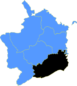
Caldicot is a hundred of Monmouthshire, named after the town of Caldicot, which it contains.
It is situated in the south-eastern part of the county, bounded on the north by the hundreds of Usk and Raglan; on the east by the River Wye, which forms the border with Gloucestershire; on the south by the Bristol Channel; and on the west by the hundred of Wentloog. Denny Island in the Bristol Channel belongs to Caldicot Hundred too.
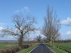
The hundred has given its name to the Caldicot level, an area of low-lying estuarine alluvial wetland and intertidal mudflats adjoining the north bank of the Severn Estuary. Like Wentloog, this hundred contains many contrasted landscapes: The high lands of Wentwood, Devauden and Chepstow Park Wood boldly tower above the fertile marshes of Level and the flat meadows on the banks of the Wye. To the south are to be found the eastern suburbs of the city of Newport, as well as the towns of Caldicot and Chepstow.
It is the second-most populous of Monmouthshire's hundreds, with a population of 98,342.
It contains the following ancient parishes:
- Bishopston
- Caerwent
- Caldicot
- Christchurch
- Green Moor (ex. par.)
- Goldcliff
- Ifton
- Itton
- Langstone
- Llanwern
- Llanvaches
- Llanmartin
- Llanvair Discoed
- Kemeys Inferior (part)*
- Llanvihangel Roggiet
- Magor
- Matherne
- Mounton
- Nash
- Newchurch
- Penhow
- Penterry
- Portskewett
- Redwick
- Rogiet
- Shirenewton
- St Arvans (including St Kingsmark, excluding Porthcasseg)†
- St Brides Netherwent
- St Pierre with Runston
- Undy
- Whitson
- Wilcrick
*: Partly in Usk Hundred.
†: Porthcasseg in Raglan Hundred.
Outside links
| Hundreds of Monmouthshire |
|---|
|
Abergavenny • Caldicot • Raglan • Skenfrith • Usk • Wentloog |

