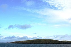
Lamba
| Lamba | |
 Beacon at south-west of Lamba | |
|---|---|
| Location | |
| Location: | 60°31’12"N, 1°17’24"W |
| Grid reference: | HU390816 |
| Area: | 106 acres |
| Highest point: | 115 feet |
| Data | |
| Population: | 0 |
Lamba is an uninhabited island in Yell Sound in Shetland. It lies a mile north of the entrance to Sullom Voe, a busy commercial inlet. It rises to no more than 115 feet above sea level and has an area of 106 acres.
The island's main features are a light 89 feet high marking the entrance to Sullom Voe,[1] and an adjacent communications mast.
There are similarly named places, including Lambay Island in County Dublin, Ireland and Lamba in the Faroe Islands.
References
- ↑ "Overview of The Lamb". Gazetteer for Scotland. http://www.scottish-places.info/features/featurefirst1814.html. Retrieved 4 October 2008.
| The islands of Yell Sound, Shetland | ||
|---|---|---|
| Yell |
Bigga • Brother Isle • Fish Holm • Lamba • Linga • Little Holm • Little Roe • Lunna Holm • Muckle Holm • Orfasay • Ramna Stacks • Samphrey • Uynarey |
Mainland
|
| Islands of Shetland |
|---|
|
Inhabited islands: |

This Shetland article is a stub: help to improve Wikishire by building it up.