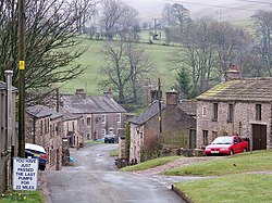
Nateby, Westmorland
| Nateby | |
| Westmorland | |
|---|---|
 Nateby | |
| Location | |
| Grid reference: | NY774067 |
| Location: | 54°27’20"N, 2°20’58"W |
| Data | |
| Population: | 120 (2011) |
| Post town: | Kirkby Stephen |
| Postcode: | CA17 |
| Dialling code: | 01768 |
| Local Government | |
| Council: | Westmorland & Furness |
| Parliamentary constituency: |
Penrith and The Border |
Nateby is a village in the east of Westmorland, about a mile and a half south of Kirkby Stephen on the upper course of the River Eden.
From here, narrow roads lead north to Kirkby Stephen, south up the dale of the Eden to Mallerstang Common and into Yorkshire, at the heads of Wensleydale and Garsdale, and south-east to the head of [{Swaledale]]. A long-distance walking route, A Pennine Journey, runs down Edendale here and through Nateby.
Nearby are the Nine Standards Rigg hills. The village contains a popular country pub, The Black Bull Inn, a garage/petrol station and a small metal-yard.
A little over half a mile to the south-west, Wharton Hall at Wharton is a mediæval fortified manor house, partly ruined and partly in use as a farmhouse.[1]
Outside links
| ("Wikimedia Commons" has material about Nateby, Westmorland) |
References
- ↑ "Wharton Hall". britishlistedbuildings.co.uk. http://www.britishlistedbuildings.co.uk/en-73046-wharton-hall-wharton. Retrieved 2011-03-08.
