Càrn an Fhidhleir: Difference between revisions
No edit summary |
No edit summary |
||
| (2 intermediate revisions by one other user not shown) | |||
| Line 4: | Line 4: | ||
|county 2=Inverness-shire | |county 2=Inverness-shire | ||
|county 3=Perthshire | |county 3=Perthshire | ||
|range= | |range=Tarf and Tilt Hills | ||
|SMC=6 | |SMC=6 | ||
|picture=Carn an Fhidhleir - geograph.org.uk - 1054007.jpg | |picture=Carn an Fhidhleir - geograph.org.uk - 1054007.jpg | ||
|picture caption=Carn an Fhidhleir from Bràigh Sròn Ghorm | |picture caption=Carn an Fhidhleir from Bràigh Sròn Ghorm | ||
|height=3,261 feet | |height=3,261 feet | ||
| | |latitude=56.935163 | ||
|longitude=-3.802738 | |||
|os grid ref=NN904841 | |os grid ref=NN904841 | ||
}} | }} | ||
'''Càrn an Fhidhleir''', also known as '''Carn Ealar''', is a mountain of the [[Grampian Mountains]] posed to the south of the [[ | '''Càrn an Fhidhleir''', also known as '''Carn Ealar''', is a mountain of the [[Tarf and Tilt Hills]], part of the [[Grampian Mountains]] posed to the south of the [[Cairngorms]]. Its summit marks the meeting of three counties: [[Aberdeenshire]], [[Inverness-shire]] and [[Perthshire]]. Càrn an Fhidhleir reaches a height of 3,261 feet at its summit, and so it qualifies as a [[Munro]]. | ||
Càrn an Fhidhleir is the most northern Munro is this region and is normally climbed in conjunction with neighbouring Munro, [[An Sgarsoch]]; these are among some of the most remote of the Munros: this region is said to be the furthest you can get from a tarred public road in Britain, so there is a long walk ahead of you no matter which direction you are coming from. The hill itself is a rounded summit with little in the way of crags. The steepest slopes are on either side of the | Càrn an Fhidhleir is the most northern Munro is this region and is normally climbed in conjunction with neighbouring Munro, [[An Sgarsoch]]; these are among some of the most remote of the Munros: this region is said to be the furthest you can get from a tarred public road in Britain, so there is a long walk ahead of you no matter which direction you are coming from. The hill itself is a rounded summit with little in the way of crags. The steepest slopes are on either side of the north-east summit ridge. A south-east ridge runs to a low col before climbing to the summit of neighbouring Munro, An Sgarsoch. This ridge is wide on peaty ground giving little in the way of technical difficulties. | ||
==Meall Tionail== | |||
'''Meall Tionail''' is a substantial subsidiary top just to the west of Carn an Fhidhleir's main summit ({{map|NN891848}}; {{wmap|56.941778|-3.823606|zoom=14}}). It reaches 2,949 feet and so narrowly fails to qualify as a Munro Top. The name 'Meall Tionail' means "Hill of the Gathering". | |||
The peak is noted for its granite outcrop. | |||
==Ascents== | ==Ascents== | ||
[[File:Carn an Fhidhleir summit - geograph.org.uk - 678894.jpg|left|thumb|220px|The edge of a plantation up to the summit]] | [[File:Carn an Fhidhleir summit - geograph.org.uk - 678894.jpg|left|thumb|220px|The edge of a plantation up to the summit]] | ||
In this remote spot, a long walk is needed, whether from the north at the A9, walking up past Glen Feshie Lodge, or from the | In this remote spot, a long walk is needed, whether from the north at the A9, walking up past Glen Feshie Lodge, or from the north-east following the [[River Dee, Aberdeenshire|River Dee]]. Another common route is from the south, from north of [[Blair Atholl]] up through Glen Tilt. Either direction allows a lot of the distance to be covered on bike through a network of stalkers paths. | ||
Càrn an Fhidhleir is thus "an expedition Munro", for though it is not spectacular, the journey to it is worthwhile for its own sake. | Càrn an Fhidhleir is thus "an expedition Munro", for though it is not spectacular, the journey to it is worthwhile for its own sake. | ||
Latest revision as of 08:25, 22 September 2018
| Càrn an Fhidhleir | |||
| Aberdeenshire, Inverness-shire, Perthshire | |||
|---|---|---|---|
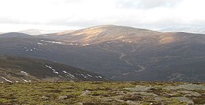
 Carn an Fhidhleir from Bràigh Sròn Ghorm | |||
| Range: | Tarf and Tilt Hills | ||
| Summit: | 3,261 feet NN904841 56°56’7"N, 3°48’10"W | ||
Càrn an Fhidhleir, also known as Carn Ealar, is a mountain of the Tarf and Tilt Hills, part of the Grampian Mountains posed to the south of the Cairngorms. Its summit marks the meeting of three counties: Aberdeenshire, Inverness-shire and Perthshire. Càrn an Fhidhleir reaches a height of 3,261 feet at its summit, and so it qualifies as a Munro.
Càrn an Fhidhleir is the most northern Munro is this region and is normally climbed in conjunction with neighbouring Munro, An Sgarsoch; these are among some of the most remote of the Munros: this region is said to be the furthest you can get from a tarred public road in Britain, so there is a long walk ahead of you no matter which direction you are coming from. The hill itself is a rounded summit with little in the way of crags. The steepest slopes are on either side of the north-east summit ridge. A south-east ridge runs to a low col before climbing to the summit of neighbouring Munro, An Sgarsoch. This ridge is wide on peaty ground giving little in the way of technical difficulties.
Meall Tionail
Meall Tionail is a substantial subsidiary top just to the west of Carn an Fhidhleir's main summit (NN891848; 56°56’30"N, 3°49’25"W). It reaches 2,949 feet and so narrowly fails to qualify as a Munro Top. The name 'Meall Tionail' means "Hill of the Gathering".
The peak is noted for its granite outcrop.
Ascents

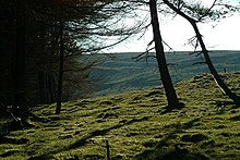
In this remote spot, a long walk is needed, whether from the north at the A9, walking up past Glen Feshie Lodge, or from the north-east following the River Dee. Another common route is from the south, from north of Blair Atholl up through Glen Tilt. Either direction allows a lot of the distance to be covered on bike through a network of stalkers paths.
Càrn an Fhidhleir is thus "an expedition Munro", for though it is not spectacular, the journey to it is worthwhile for its own sake.
| Munros in SMC Area SMC Section 6 - Glen Garry to Braemar |
|---|
|
An Sgarsoch • An Socach • Beinn Dearg • Beinn Iutharn Mhòr • Beinn a' Ghlò • Càrn a' Chlamain • Carn a' Gheoidh • Càrn an Fhidhleir • Carn an Righ • Carn Aosda • Càrn Bhac • Beinn a' Ghlò • Beinn a' Ghlò • Glas Tulaichean • The Cairnwell |