Sgùrr nan Conbhairean: Difference between revisions
Created page with '{{Infobox hill |name=Sgurr nan Conbhairean |county 1=Ross-shire |county 2=Inverness-shire |range=Glen Shiel Hills |SMC=11 |picture=Sgurr nan Conbhairean with snow patches - geogr…' |
No edit summary |
||
| (One intermediate revision by one other user not shown) | |||
| Line 8: | Line 8: | ||
|picture caption= | |picture caption= | ||
|height=3,638 feet | |height=3,638 feet | ||
| | |latitude=57.176748 | ||
|longitude=-5.096787 | |||
|os grid ref=NH129138 | |os grid ref=NH129138 | ||
}} | }} | ||
| Line 15: | Line 16: | ||
The mountain stands on the north side of Glen Shiel, toward the eastern end of the North Glen Shiel ridge, north of [[Loch Cluanie]]. Four craggy ridges meet at its summit, three leading to fellow Munros: | The mountain stands on the north side of Glen Shiel, toward the eastern end of the North Glen Shiel ridge, north of [[Loch Cluanie]]. Four craggy ridges meet at its summit, three leading to fellow Munros: | ||
*[[Càrn Ghluasaid]] is just to the | *[[Càrn Ghluasaid]] is just to the south-east beyond the Glas Bealach and the Munro Top of Craig a' Chaorainn; | ||
*[[Sàil Chaorainn]] is to the north; | *[[Sàil Chaorainn]] is to the north; | ||
*[[A' Chràileag]] is further to the west, past the high top of Droichaid an Tuill-Easaich and the Bealach Choire a' Chait. | *[[A' Chràileag]] is further to the west, past the high top of Droichaid an Tuill-Easaich and the Bealach Choire a' Chait. | ||
| Line 25: | Line 26: | ||
{{commons}} | {{commons}} | ||
{{Munro}} | {{Munro}} | ||
{{DEFAULTSORT:Sgurr Nan Conbhairean}} | |||
{{stub}} | {{stub}} | ||
Latest revision as of 18:08, 31 May 2017
| Sgurr nan Conbhairean | |||
| Ross-shire, Inverness-shire | |||
|---|---|---|---|

| |||
| Range: | Glen Shiel Hills | ||
| Summit: | 3,638 feet NH129138 57°10’36"N, 5°5’48"W | ||
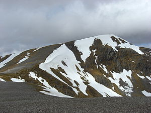
Sgùrr nan Conbhairean is a mountain in the Glen Shiel Hills, the district packed with high hills where Ross-shire and Inverness-shire meet near the west coast. Sgùrr nan Conbhairean itself stands on the border of the two shires, and reaches a height of 3,638 feet at its summit, and so it qualifies as a Munro. Its name means "Peak of the hound keeper".
The mountain stands on the north side of Glen Shiel, toward the eastern end of the North Glen Shiel ridge, north of Loch Cluanie. Four craggy ridges meet at its summit, three leading to fellow Munros:
- Càrn Ghluasaid is just to the south-east beyond the Glas Bealach and the Munro Top of Craig a' Chaorainn;
- Sàil Chaorainn is to the north;
- A' Chràileag is further to the west, past the high top of Droichaid an Tuill-Easaich and the Bealach Choire a' Chait.
The south ridge leads down towards the loch.

| ("Wikimedia Commons" has material about Sgùrr nan Conbhairean) |
| Munros in SMC Area SMC Section 11 - Glen Affric and Kintail |
|---|
|
A' Chràlaig • A' Ghlas-bheinn • An Socach • Aonach Meadhoin • Beinn Fhionnlaidh • Ben Attow • Carn Eige • Carn Ghluasaid • Ciste Dhubh • Mam Sodhail • Mullach Fraoch-choire • Mullach na Dheiragain • Sail Chaorainn • Saileag • Sgùrr a' Bhealaich Dheirg • Sgùrr Fhuaran • Sgùrr na Càrnach • Sgùrr na Ciste Duibhe • Sgùrr nan Ceathramhnan • Sgùrr nan Conbhairean • Toll Creagach • Tom a' Choinich
This Mountain or hill article is a stub: help to improve Wikishire by building it up. |
