London: Difference between revisions
Jettisoned (talk | contribs) Census info |
|||
| (2 intermediate revisions by 2 users not shown) | |||
| Line 19: | Line 19: | ||
'''London''' is the capital and largest city of [[England]] and the [[United Kingdom]]. Standing on the [[River Thames]] in south-east England, it has been a major settlement for two millennia. The [[City of London]], founded in AD 47 as ''[[Londinium]]'', is at its core, with the vast conurbation surrounding it covering almost the rest of [[Middlesex]], much of north-eastern [[Surrey]], north-western [[Kent]], south-western [[Essex]] and parts of [[Hertfordshire]]. | '''London''' is the capital and largest city of [[England]] and the [[United Kingdom]]. Standing on the [[River Thames]] in south-east England, it has been a major settlement for two millennia. The [[City of London]], founded in AD 47 as ''[[Londinium]]'', is at its core, with the vast conurbation surrounding it covering almost the rest of [[Middlesex]], much of north-eastern [[Surrey]], north-western [[Kent]], south-western [[Essex]] and parts of [[Hertfordshire]]. | ||
Since the 19th century, the name "London" has been attached to this wider metropolis.<ref name="mills_140">Harvard - Mills, 2001, p=140}}</ref> However, the City of London is the only part whose proper name is "London". The City, known as 'the Square Mile', largely retains its mediaeval boundaries. It is no longer a major residential area but serves as the chief financial district. The | Since the 19th century, the name "London" has been attached to this wider metropolis.<ref name="mills_140">Harvard - Mills, 2001, p=140}}</ref> However, the City of London is the only part whose proper name is "London". The City, known as 'the Square Mile', largely retains its mediaeval boundaries. It is no longer a major residential area but serves as the chief financial district. The city of [[Westminster]], to the west of the City of London, has been the seat of the British government, and before it the English government, for almost a thousand years. | ||
As one of the world's major global cities, London exerts a strong influence on its arts, entertainment, fashion, commerce and finance, education, health care, media, science and technology, tourism, and transport and communications. Its GDP makes it the largest urban economy in Europe, and it is one of the major financial centres in the world. With Europe's largest concentration of higher education institutions, it is home to some of the highest-ranked academic institutions in the world—Imperial College London in natural and applied sciences, the London School of Economics in social sciences, and the comprehensive University College London. London is the most visited city in Europe and has the busiest city airport system in the world. The [[London Underground]] is the oldest rapid transit system in the world. | As one of the world's major global cities, London exerts a strong influence on its arts, entertainment, fashion, commerce and finance, education, health care, media, science and technology, tourism, and transport and communications. Its GDP makes it the largest urban economy in Europe, and it is one of the major financial centres in the world. With Europe's largest concentration of higher education institutions, it is home to some of the highest-ranked academic institutions in the world—Imperial College London in natural and applied sciences, the London School of Economics in social sciences, and the comprehensive University College London. London is the most visited city in Europe and has the busiest city airport system in the world. The [[London Underground]] is the oldest rapid transit system in the world. | ||
Latest revision as of 22:23, 12 August 2023
| London | |
| Middlesex, Essex, Surrey, Kent, Hertfordshire | |
|---|---|
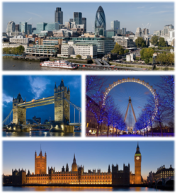 City of London, Tower Bridge London Eye, Palace of Westminster | |
| Location | |
| Grid reference: | TQ3181 |
| Location: | 51°30’26"N, 0°7’39"W |
| Data | |
| Population: | 9,787,426 (2011 - ONS London Urban Area) |
| Post town: | London and various |
| Postcode: | E, EC, N, NW, SE, SW, W, WC and various |
| Dialling code: | 020 and various |
| Local Government | |
London is the capital and largest city of England and the United Kingdom. Standing on the River Thames in south-east England, it has been a major settlement for two millennia. The City of London, founded in AD 47 as Londinium, is at its core, with the vast conurbation surrounding it covering almost the rest of Middlesex, much of north-eastern Surrey, north-western Kent, south-western Essex and parts of Hertfordshire.
Since the 19th century, the name "London" has been attached to this wider metropolis.[1] However, the City of London is the only part whose proper name is "London". The City, known as 'the Square Mile', largely retains its mediaeval boundaries. It is no longer a major residential area but serves as the chief financial district. The city of Westminster, to the west of the City of London, has been the seat of the British government, and before it the English government, for almost a thousand years.
As one of the world's major global cities, London exerts a strong influence on its arts, entertainment, fashion, commerce and finance, education, health care, media, science and technology, tourism, and transport and communications. Its GDP makes it the largest urban economy in Europe, and it is one of the major financial centres in the world. With Europe's largest concentration of higher education institutions, it is home to some of the highest-ranked academic institutions in the world—Imperial College London in natural and applied sciences, the London School of Economics in social sciences, and the comprehensive University College London. London is the most visited city in Europe and has the busiest city airport system in the world. The London Underground is the oldest rapid transit system in the world.
London has numerous World Heritage Sites, including the Tower of London; the site of the Palace of Westminster, Westminster Abbey and St Margaret's Church; Kew Gardens in Surrey; and the historic settlement at Greenwich in Kent, where the Royal Observatory, Greenwich defines the prime meridian (0° longitude) and Greenwich Mean Time. Other landmarks include St Paul's Cathedral, Buckingham Palace, Tower Bridge, and the London Eye. London has many museums, galleries, libraries and cultural venues, including the British Museum, and numerous West End theatres.
Global city
London is a leading global city, the world's largest financial centre alongside New York,[2][3][4] and has the largest city GDP in Europe.[5] Central London is home to the headquarters of most of Britain's top 100 listed companies (the FTSE 100) and more than 100 of Europe's 500 largest. London's influence and strengths in the arts, education, entertainment, fashion, finance, healthcare, media, politics, professional services, sports, tourism, transport and culture in general all contribute to its global position.
London is the World's most visited city [6]
London has a diverse range of peoples, cultures and religions, and more than 300 languages are spoken within its boundaries.[7] The "Greater London Urban Area" of London and its surrounding towns in the Home Counties s defined by statisticians has a population of 8,278,251.[8]
World Heritage Sites
London contains four World Heritage Sites:
- the Tower of London;
- the Royal Botanic Gardens, Kew;
- the site comprising the Palace of Westminster, Westminster Abbey and St. Margaret's, Westminster;
- Greenwich (in which the Royal Observatory marks the Greenwich Meridian (0° longitude) and Greenwich Mean Time).[9]
Transport hub
The London Underground network, administered by Transport for London, is the oldest underground railway network in the world and the most extensive after the Shanghai Metro.[10]
Heathrow Airport (serving London from western Middlesex) is the world's busiest airport by number of international passengers[11] and the airspace is the busiest of any urban centre in the world.[12]
The road network in southern Britain converges on London as its primary hub, with the major trunk roads radiating from it. To alleviate the problem caused by traffic thus forced towards London, the M25 orbital motorway was built, looping through the countryside and the suburban fringe in Kent, Surrey, Middlesex, Buckinghamshire, Hertfordshire and Essex.
London is also the primary regional hub for the rail network.
Identifying "London"
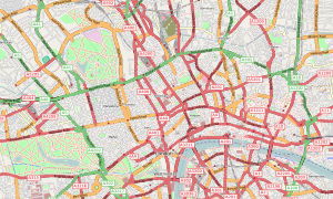
The boundaries of "London" cannot easily be defined. The name strictly speaking belongs in propriety to the City of London, one square mile at the core of the conurbation and which once contained the whole town.
As the urban area grew far beyond the City's boundaries the City itself remained, absorbing the "Liberties of the City" immediately beyond its original boundaries but no more. The Corporation of the City of London resisted attempts to amalgamate it with its suburbs, causing "London" to be defined in a number ways for different purposes; and the situation was once open to legal debate.[13] In 1889 an administrative area named "the administrative county of London" was created to manage the urban area beyond the city, though the town growth swiftly made that area irrelevant. The contiguous urban and suburban area now covers almost all of Middlesex and large swathes of north-eastern Surrey, north-western Kent, south-western Essex and the southern fringe of Hertfordshire, with dormitory towns and suburbs stretching beyond.
Nevertheless, the towns found within the contiguous suburban area stretching out from London retain their own identities and "London" cannot be defined simply by counting houses.
London post town
The "London" post town is the area within which 'London' forms part of the official postal address according to the Royal Mail.[14][15] The post town was adopted and defined as a matter of convenience by the Post Office, and when it was laid down it stretched beyond the edge of what was then the urban area. Notwithstanding the limited relevance of this device, the description of an address as "London" has an effect on local identity. This was identified as far back as the 1950s, when Middlesex County Council tried to object to the extent of the post town area.[16]
Green Belt
Outward urban expansion is now restrained by a metropolitan "green belt",[17] within which planners are required to discourage new building. The built-up area extends into the Green Belt in places.
Commuter belt
Beyond the London urban area is the vast London commuter belt,[18] made up of the towns and villages from which people travel into London each morning to work.
Central London
"Central London" is not formally defined. The traditional centre of London was the London Stone in the City, the stone which has been in place since Roman times, and was the start of mileposts throughout Britannia. The London Stone is now unceremoniously encaged within the outer wall of a bank on Fleet Street.
Since the expansion of the town westward, the nominal centre of London has been placed at the site of the Charing Cross, near the junction of Trafalgar Square and Whitehall, approximately 51° 30' 26" N, 0° 7' 39" W.[19]
The River Thames
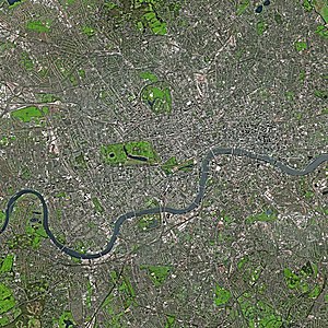
London stands athwart the River Thames, its primary geographical feature, a river navigable as far as Cricklade in Oxfordshire and by large ships as far as Teddington Lock. Several bridges cross the river. Away from the river, Middlesex has gently rolling hills including Parliament Hill, the Addington Hills, and Primrose Hill, and the upland of Hampstead Heath. The Thames was once a much broader, shallower river with extensive marshland; at high tide, its shores reached five times their present width.[20]
In the Victorian era the Thames was extensively embanked, and many of its tributaries were culverted or their waters diverted to flush through the system of sewers established by Joseph Bazalgette.
The threat of catastrophic tidal flooding from Thames became a concern in the 1970s, resulting in the construction of the Thames Barrier across the river between Woolwich in Kent and Silvertown in Essex. The Barrier opened in 1984.
Districts
London's vast urban area is not uniform. It has been constructed not from the centre but by the conglomeration of towns and villages, each swelling with new housing developments, or from ribbon development along the roads joining the towns. The town and village names remain in use, even for areas which have largely lost their own village centres to become mere districts of the larger town.
Each local area or town with the town has its own distinctive character. Some new districts have been developed too, such as Canary Wharf, developed fro scratch in the 1980s as a new financial and commercial hub in the Docklands to the east of the City.
The West End
The West End, the townscape west of the City, is the main entertainment and shopping district, attracting tourists.[21] It has the highest land values outside the City; houses can sell for tens of millions of pounds.[22] Even within the West End there are distinct districts, such as Marylebone, Bloomsbury and Westminster. Developments by the great London estates from the eighteenth century grew from what had been green field sites and are now at the heart of the metropolis. They retain a shadow of the Middlesex fields from which they were built in the distinctive private squares in many areas.
The East End
The East End is the area closest to the original Port of London, known for its high immigrant population, as well as for being one of the poorest areas in London.[23]
Architecture

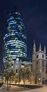
London's buildings are too diverse to be characterised by any particular architectural style, having been built over many centuries. The City itself has seventeenth century buildings jostling with twenty-first century glass towers.
High-rise development is restricted at certain sites if it would obstruct protected views of St Paul's Cathedral. Nevertheless, there are plans for more skyscrapers in Central London, to complement the 72-storey "Shard of Glass", which is one of the tallest buildings in Europe.
Older buildings are mainly brick-built, most commonly the yellow London stock brick or a warm orange-red variety, often decorated with carvings and white plaster mouldings.[24]
Many grand houses and public buildings, such as the National Gallery, are constructed from Portland stone. Some areas of the city, particularly those just west of the centre, are characterised by white stucco or whitewashed buildings. Few structures pre-date the Great Fire of 1666, except for a few trace Roman remains, the Tower of London and a few scattered Tudor survivors in the City. Wren's late 17th century churches and the financial institutions of the 18th and 19th centuries such as the Royal Exchange and the Bank of England, to the early 20th century Old Bailey and the 1960s Barbican Estate form part of the varied architectural heritage.
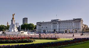
The Monument in the City of London provides views of the surrounding area while commemorating the Great Fire of London, which originated nearby. Marble Arch and Wellington Arch, at the north and south ends of Park Lane respectively, have royal connections, as do the Albert Memorial and Royal Albert Hall in Kensington. Nelson's Column is a nationally recognised monument in Trafalgar Square, one of the focal points of the centre.
In the dense areas, most of the concentration is achieved with medium- and high-rise buildings. London's skyscrapers such as the "Gherkin", "Tower 42", the Broadgate Tower and One Canada Square are usually found in the two financial districts, the City of London and Canary Wharf. Other notable modern buildings include City Hall in Southwark with its distinctive oval shape,[25] and the British Library in Somers Town/Kings Cross.
Parks and gardens
The largest parks in the central area of London are the Royal Parks of Hyde Park, its neighbour Kensington Gardens and Regent's Park, all in Middlesex.
Regent's Park contains London Zoo, the world's oldest scientific zoo. Green Park and St James's Park are close to Buckingham Palace.
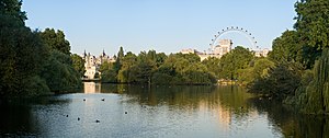
Hyde Park in particular is popular for sports and sometimes hosts open-air concerts.
Some more informal, semi-natural open spaces also exist, including Hampstead Heath in Middlesex, to the north of Central London. This incorporates Kenwood House, the former stately home and a popular location in the summer months where classical musical concerts are held by the lake, attracting thousands of people every weekend to enjoy the music, scenery and fireworks.[26]
Churches
- See also Diocese of London
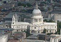
London has traditionally been Christian, and has a large number of churches, particularly in the City of London. The well-known St Paul's Cathedral in the City and Southwark Cathedral in Surrey are the Church of England's principal cathedrals serving the urban area. The Archbishop of Canterbury has his main residence not in Canterbury but at Lambeth Palace in Lambeth, Surrey.[27]
Important national and royal ceremonies are shared between St Paul's and Westminster Abbey.
People
With increasing industrialisation, London's population grew rapidly throughout the 19th and early 20th centuries, and it was for some time in the late 19th and early 20th centuries the most populous city in the world until overtaken by New York in 1925.
According to "Eurostat", London is the most populous city and metropolitan area of the European Union and the second in Europe (or third if Constantinople is included). During the period 1991–2001 a net 726,000 immigrants arrived in London.[28]
Ethnic groups
According to the Office for National Statistics, based on 2007 estimates, 69.0 per cent of the 7.5 million inhabitants of the London statistical area (which is to say London and the urbans area surrounding it in Middlesex and in the other Home Counties) were White, with 57.7 per cent White British, 2.4 per cent Irish and 8.9 per cent classified as "Other White". Some 13.3 per cent are of South Asian descent, with Indians making up 6.6 per cent of London's population, followed by Pakistanis and Bangladeshis at 2.4 per cent and 2.3 per cent respectively. 2.0 per cent are categorised as "Other Asian".
10.6 per cent of London's population are statisticallt categorised as Black, with around 5.5 per cent being Black African, 4.3 per cent as Black Caribbean and 0.8 per cent as "Other Black". 3.5 per cent of Londoners are of mixed race; 1.5 per cent are Chinese; and 2.0 per cent belong to another ethnic group.[29] As of 2008, 40% of London's total population was from an ethnic minority group.[30]
Across London, Black and Asian children outnumber White British children by about six to four in state schools.[31] In January 2005, a survey of London's ethnic and religious diversity claimed that there were more than 300 languages spoken and more than 50 non-indigenous communities which have a population of more than 10,000 in London.[32] Figures from the Office for National Statistics show that, as of 2006, London's foreign-born population is 2,288,000 (31%), up from 1,630,000 in 1997.[33]
Religion
The majority of Londoners – 58.2% – identify themselves as Christians.[34] This is followed by those of no religion (15.8%), Muslims (8.5%), Hindus (4.1%), Jews (2.1%), Sikhs (1.5%), Buddhists (0.8%), Pagans (0.3%) and other (0.2%), though 8.7% of people did not answer this question in the 2001 Census.[34]
Many Muslims live in the East End and Stratford. The most important Muslim edifice is London Central Mosque on the edge of Regent's Park.[35] Following the oil boom, increasing numbers of wealthy Middle-Eastern Muslims have based themselves around Mayfair and Knightsbridge in Middlesex.[36][37]
London's large Hindu community is found in the north-western parts of Middlesex such as Harrow and Neasden; Neasden Temple is one of Europe's largest Hindu temples.[38] Sikh communities are located in the east and the west.
The majority of British Jews live in London, with significant Jewish communities in Stamford Hill, Stanmore, Golders Green, Hampstead, Hendon and Edgware all in Middlesex. The Stanmore and Canons Park Synagogue has the largest membership of any single Orthodox synagogue in the whole of Europe, overtaking the Ilford synagogue in metrolpolitan Essex in 1998.[39] The community set up the London Jewish Forum in 2007 in response to the growing significance of devolved London Government.[40]
Notes
References
Footnotes
- ↑ Harvard - Mills, 2001, p=140}}
- ↑ "Global Financial Centres 7". Z/Yen. 2010. http://www.zyen.com/PDF/GFC%207.pdf#page=30. Retrieved 2010-04-21.
- ↑ "World's Most Economically Powerful Cities". Forbes.com
- ↑ "Worldwide Centres of Commerce Index 2008". Mastercard. http://www.mastercard.com/us/company/en/insights/pdfs/2008/MCWW_WCoC-Report_2008.pdf.
- ↑ "World Urbanization Prospects: The 2007 Revision Population Database". The United Nations. http://esa.un.org/unup/index.asp?panel=2. Retrieved 21 November 2009.
- ↑ Bremner, Caroline (11 October 2007). "Top 150 city destinations: London leads the way". Euromonitor International. http://www.euromonitor.com/Top_150_City_Destinations_London_Leads_the_Way. Retrieved 28 August 2008.
- ↑ "Languages spoken in the UK population". CILT, the National Centre for Language. http://www.cilt.org.uk/faqs/langspoken.htm. Retrieved 2008-06-06.
- ↑ "KS01 Usual resident population: Census 2001, Key Statistics for urban areas". Office for National Statistics. http://www.statistics.gov.uk/statbase/ssdataset.asp?vlnk=8271&More=Y. Retrieved 2008-06-06.
- ↑ "Lists: United Kingdom of Great Britain and Northern Ireland". UNESCO. http://whc.unesco.org/en/statesparties/gb. Retrieved 2008-11-26.
- ↑ "Shanghai now the world's longest metro". Railway Gazette International. 4 May 2010. http://www.railwaygazette.com/news/single-view/view/10/shanghai-now-the-worlds-longest-metro.html. Retrieved 4 May 2010.
- ↑ "Top ten world airports – 2004" (PDF). http://www.heathrowairport.com/assets/B2CPortal/Static%20Files/TopAirports04.pdf. Retrieved 2008-03-07.
- ↑ "International Passenger Traffic, Airports Council International". Aci.aero. http://www.aci.aero/cda/aci/display/main/aci_content.jsp?zn=aci&cp=1-5-212-1376-1380_9_2__. Retrieved 2010-05-03.
- ↑ Beavan, Charles; Bickersteth, Harry (1865). Reports of Cases in Chancery, Argued and Determined in the Rolls Court. Saunders and Benning. http://books.google.com/?id=YFYDAAAAQAAJ.
- ↑ Stationery Office (1980). The Inner London Letter Post. H.M.S.O. p. 128. ISBN 0102515808.
- ↑ Geographers' A-Z Map Company (2008). London Postcode and Administrative Boundaries (6 ed.). Geographers' A-Z Map Company. ISBN 9781843485926.
- ↑ Records of the Middlesex County Council – Public Relations Officer, 1954
- ↑ Dilys, M Hill (2000). Urban Policy and Politics in Britain. St. Martin's Press. p. 268. ISBN 0312227450.
- ↑ "London in its Regional Setting (PDF)" (PDF). London Assembly. http://www.london.gov.uk/assembly/reports/plansd/london_regional_200104.pdf. Retrieved 2008-06-06.
- ↑ "London — Features — Where is the Centre of London?". British Broadcasting Corporation. http://www.bbc.co.uk/london/content/articles/2005/08/15/charingcross_feature.shtml. Retrieved 2008-06-06.
- ↑ London: A History, by Francis Sheppard page 10.. Google Books. 2000. ISBN 9780192853691. http://books.google.com/?id=M9qvtYYhRtAC&pg=PR11&dq=thames+%22iron+age%22+london+wide+geography+shallow+marsh. Retrieved 2008-06-06.
- ↑ "West End still drawing crowds". BBC. British Broadcasting Corporation. 2001-10-22. http://news.bbc.co.uk/2/hi/entertainment/1608619.stm. Retrieved 2008-06-06.
- ↑ Meek, James (17 April 2006). "Super Rich". London: The Guardian Money. http://www.guardian.co.uk/money/2006/apr/17/tax.g2. Retrieved 2008-06-07.
- ↑ "Tomorrow's East End". News Week. Archived from the original on 2006-08-29. http://web.archive.org/web/20060829024354/http://msnbc.msn.com/id/8487518/site/newsweek/. Retrieved 2007-08-16.
- ↑ Lonsdale, Sarah (2008-03-27). "Eco homes: Wooden it be lovely... ?". London: Telegraph Media Group Limited. http://www.telegraph.co.uk/property/main.jhtml?view=DETAILS&grid=A1&xml=/property/2008/03/27/lpgreen127.xml. Retrieved 2008-10-12.
- ↑ "Inside London's new 'glass egg'". British Broadcasting Corporation. 16 July 2002. http://news.bbc.co.uk/1/hi/uk/2129199.stm. Retrieved 2008-04-26.
- ↑ "Kenwood House". English Heritage. http://www.english-heritage.org.uk/server/show/nav.00100200800k00800f. Retrieved 2008-04-26.
- ↑ "Lambeth Palace Library". Lambeth Palace Library. http://www.lambethpalacelibrary.org/. Retrieved 2008-04-27.
- ↑ Leppard, David (2005-04-10). "Immigration rise increases segregation in British cities". Times Online. London: TimesOnline.co.uk. http://www.timesonline.co.uk/tol/news/uk/article379434.ece. Retrieved 2009-08-08.
- ↑ "Neighbourhood Statistics". Neighbourhood Statistics. http://www.neighbourhood.statistics.gov.uk/dissemination/LeadTableView.do?a=7&b=276743&c=london&d=13&e=13&g=325264&i=1001x1003x1004&m=0&r=1&s=1280577856710&enc=1&dsFamilyId=1812. Retrieved 2010-07-31.
- ↑ London's black and minority communities helped to have a greater voice. londoncouncils.gov.uk
- ↑ Graeme Paton (2007-10-01). "One fifth of children from ethnic minorities". The Daily Telegraph. London. http://www.telegraph.co.uk/news/uknews/1564365/One-fifth-of-children-from-ethnic-minorities.html. Retrieved 2008-06-07.
- ↑ Benedictus, Leo (2005-01-21). "London: Every race, colour, nation and religion on earth". Guardian. http://www.guardian.co.uk/uk/2005/jan/21/britishidentity1. Retrieved 2008-05-06.
- ↑ "One Third of Londoners born outside Britain". Evening Standard / Office for National Statistics. http://www.thisislondon.co.uk/news/article-23374397-details/%27One-third+of+Londoners+born+outside+Britain%27/article.do. Retrieved 2008-06-06.
- ↑ 34.0 34.1 "Census 2001 profiles: London". www.statistics.gov.uk. Office for National Statistics. http://www.statistics.gov.uk/census2001/profiles/H-A.asp#ethnic. Retrieved 2008-08-19.
- ↑ "London Central Mosque Trust Ltd". London Central Mosque Trust Ltd. & The Islamic Cultural Centre. http://www.iccuk.org/index.php?article=1&PHPSESSID=rbt2vceqs1bpn9567k0kiv9hu5. Retrieved 2008-04-27.
- ↑ "The $300 billion Arabs are coming". Thisislondon.co.uk. http://www.thisislondon.co.uk/standard/article-23488244-the-300-billion-arabs-are-coming.do. Retrieved 2010-05-03.
- ↑ "The Mecca of the West | 1970–1979 | Guardian Century". 209.85.229.132. http://209.85.229.132/search?q=cache:CdN4XS_A5eAJ:century.guardian.co.uk/1970-1979/Story/0,,106930,00.html+arabs+in+london&cd=13&hl=en&ct=clnk&gl=uk. Retrieved 2010-03-10.
- ↑ "Hindu London". British Broadcasting Corporation. 6 June 2005. http://www.bbc.co.uk/london/content/articles/2005/05/19/hindu_london_feature.shtml. Retrieved 2006-06-03.
- ↑ "Jewish Agency". Jewish Agency. http://www.jewishagency.org/JewishAgency/English/Israel/Partnerships/Regions/Kavimut/Britain+Communities/Stanmore+11.htm. Retrieved 2008-10-12.
- ↑ "About Us — Mission Statement". London Jewish Forum. http://www.ljf.org.uk/London%20Jewish%20Forum/About%20us.html. Retrieved 2008-10-12.
Bibliography
- Ackroyd, Peter (2001). London: The Biography. London: Vintage. p. 880. ISBN 0099422581.
- Aubin, Robert Arnold (February 2008). London in flames, London in glory: poems on the fire and rebuilding of London. Rutgers University Press on's Concerts" /> London's two muthor=Mayor of London. http://www.london.gov.uk/thelondonplan/docs/londonplan08.pdf.
- Miles, Barry (2010). London Calling. Atlantic Books. ISBN 9781842546139.
- Mills, David (2001). Dictionary of London Place Names. Oxford Paperbacks. ISBN 978-0192801067. OCLC 45406491.
- Noorthouk, J (1773). "A New History of London". Centre for Metropolitan History. http://www.british-history.ac.uk/source.aspx?pubid=332.
- Porter, Roy. History of London (1995), by a leading historian
- Reddaway, Thomas Fiddian (1940). The Rebuilding of London After the Great Fire. Jonathan Cape.
- Travers, Tony (2004). The Politics of London. Palgrave. ISBN 1861341725.
Outside links
- British Pathé Digitalised archive containing hundreds of films of 20th century London
- London in British History Online, with links to numerous authoritative online sources
- Vintage London: Taking in the Smoke - slideshow by Life magazine
- Office for National Statistics: Focus on London 2007 – compendium of official statistics
- Map of Early Modern London – Historical Map and Encyclopaedia of Shakespeare's London (Scholarly)
- Museum of London Group Portal – Home
- History of London – The history of London over centuries.
- Poems about London at Poetry Atlas