East Wivelshire: Difference between revisions
Jump to navigation
Jump to search
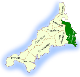
Created page with "right|thumb|270px|East Wivelshire located '''East Wivelshire''' is the south-easternmost of the ten hundreds of Cornwall, along the lower reaches..." |
mNo edit summary |
||
| (5 intermediate revisions by the same user not shown) | |||
| Line 1: | Line 1: | ||
[[File:East Wivelshire.svg|right|thumb|270px|East Wivelshire located]] | [[File:East Wivelshire.svg|right|thumb|270px|East Wivelshire located]] | ||
'''East Wivelshire''' is the south-easternmost of the ten hundreds of Cornwall, along the lower reaches of the [[River Tamar]] and the manifold creeks that indent its complex estuary and as far north as [[Launceston]]. The hundred is the eastern part of the wider district known as [[Wivelshire]]. | '''East Wivelshire''' is the south-easternmost of the ten hundreds of Cornwall, along the lower reaches of the [[River Tamar]] and the manifold creeks that indent its complex estuary and as far north as [[Launceston]]. The hundred is the eastern part of the wider district known as [[Wivelshire]]. It is identified on [[Ordnance Survey]] maps and census reports as simply the '''East Hundred'''. It had a population of 71,779 in 2011, falling to 71,203 if detached parts are disregarded. | ||
The parishes of East Wivelshire are: | The ancient parishes of East Wivelshire are: | ||
[[Category: | {{div col|3}} | ||
*[[Antony|Antony St Jacob]] | |||
*[[Botus Fleming]] | |||
*[[Callington]] | |||
*[[Calstock]] | |||
*[[Egloskerry]] | |||
*[[Landulph]] | |||
*[[Landrake]] [with St Erney] | |||
*[[Laneast]] | |||
*[[Launceston|Launceston St Mary Magdalene]] | |||
*[[Lawhitton]] | |||
*[[Lewannick]] | |||
*[[Lezant]] | |||
*[[Linkinhorne]] | |||
*[[Maker, Cornwall|Maker]] (part)<sup>*</sup> | |||
*[[St Mellion]] | |||
*[[Menheniot]] | |||
*[[North Hill, Cornwall|North Hill]] | |||
*[[Pillaton]] | |||
*[[Quethiock]] | |||
*[[Rame]] | |||
*[[Sheviock]] | |||
*[[South Hill, Cornwall|South Hill]] | |||
*[[South Petherwin]] | |||
*[[St Budeaux]] (part)<sup>†</sup> | |||
*[[St Germans, Cornwall|St Germans]] | |||
*[[St John, Cornwall|St John]] | |||
*[[St Stephen-by-Launceston|St Stephens-with-Newport]] | |||
*[[Stoke Climsland]] | |||
*[[St Dominick, Cornwall|St Dominick]] | |||
*[[St Ive]] | |||
*[[Saltash|St Stephen-by-Saltash]] | |||
*[[St Thomas Apostle-by-Launceston]] | |||
*[[Tremaine, Cornwall|Tremaine]] | |||
*[[Tresmeer]] | |||
*[[Trewen]] | |||
{{div col end}} | |||
<sup>*</sup>: Vaultersholme in Devon.<br /> | |||
<sup>†</sup>: ''[[Cornish patch]]''; Parish mostly in Devon. | |||
{{Cornwall hundreds}} | |||
[[Category:Pseudo-shires]] | |||
Latest revision as of 16:01, 1 November 2022

East Wivelshire is the south-easternmost of the ten hundreds of Cornwall, along the lower reaches of the River Tamar and the manifold creeks that indent its complex estuary and as far north as Launceston. The hundred is the eastern part of the wider district known as Wivelshire. It is identified on Ordnance Survey maps and census reports as simply the East Hundred. It had a population of 71,779 in 2011, falling to 71,203 if detached parts are disregarded.
The ancient parishes of East Wivelshire are:
- Antony St Jacob
- Botus Fleming
- Callington
- Calstock
- Egloskerry
- Landulph
- Landrake [with St Erney]
- Laneast
- Launceston St Mary Magdalene
- Lawhitton
- Lewannick
- Lezant
- Linkinhorne
- Maker (part)*
- St Mellion
- Menheniot
- North Hill
- Pillaton
- Quethiock
- Rame
- Sheviock
- South Hill
- South Petherwin
- St Budeaux (part)†
- St Germans
- St John
- St Stephens-with-Newport
- Stoke Climsland
- St Dominick
- St Ive
- St Stephen-by-Saltash
- St Thomas Apostle-by-Launceston
- Tremaine
- Tresmeer
- Trewen
*: Vaultersholme in Devon.
†: Cornish patch; Parish mostly in Devon.
| Hundreds of Cornwall |
|---|
|
East Wivelshire • Kerrier • Lesnewth • Penwith • Powdershire • Pydershire • Isles of Scilly • Stratton • Triggshire • West Wivelshire |