Chester: Difference between revisions
No edit summary |
mNo edit summary |
||
| (2 intermediate revisions by the same user not shown) | |||
| Line 14: | Line 14: | ||
|os grid ref= SJ405665 | |os grid ref= SJ405665 | ||
}} | }} | ||
'''Chester''' is a city and county town of [[Cheshire]]. It is an ancient and historic city, standing on the [[River Dee]], close to the border with [[Flintshire]] and by the root of the [[Wirral]] Peninsula. Chester is home to some 77,040 and is one of the largest towns of the | '''Chester''' is a city and [[county town]] of [[Cheshire]]. It is an ancient and historic city, standing on the [[River Dee]], close to the border with [[Flintshire]] and by the root of the [[Wirral]] Peninsula. Chester is home to some 77,040 and is one of the largest towns of the county. Chester received letters patent creating it a city in 1541. | ||
Chester was founded as a Roman fort with the name ''Deva Victrix'' in the year 79 by the Roman ''Legio II Adiutrix'' during the reign of the Emperor Vespasian. Its four main roads, Eastgate, Northgate, Watergate and Bridge, follow routes laid out at this time – almost 2,000 years ago. One of the three main Roman army bases, Deva later became a major settlement in the Roman province of Britannia. | Chester was founded as a Roman fort with the name ''Deva Victrix'' in the year 79 by the Roman ''Legio II Adiutrix'' during the reign of the Emperor Vespasian. Its four main roads, Eastgate, Northgate, Watergate and Bridge, follow routes laid out at this time – almost 2,000 years ago. One of the three main Roman army bases, Deva later became a major settlement in the Roman province of Britannia. | ||
Chester has many mediæval buildings, but some of the black-and-white buildings within the city centre are Victorian restorations.<ref>Pevsner and Hubbard, pp. 130–131.</ref> Chester is one of the best preserved walled cities in the British Isles. Apart from a 330-foot section, the Grade I listed walls are almost complete.<ref name=m43/> | Chester has many mediæval buildings, but some of the black-and-white buildings within the city centre are Victorian restorations.<ref>Pevsner and Hubbard, pp. 130–131.</ref> Chester is one of the best preserved walled cities in the British Isles. Apart from a 330-foot section, the Grade-I-listed walls are almost complete.<ref name=m43/> | ||
The Industrial Revolution brought railways, canals, and new roads to the city, which saw substantial expansion and development. Chester Town Hall and the Grosvenor Museum are examples of the grand Victorian architecture of this period. | The Industrial Revolution brought railways, canals, and new roads to the city, which saw substantial expansion and development. Chester Town Hall and the Grosvenor Museum are examples of the grand Victorian architecture of this period. | ||
==Lie of the land== | ==Lie of the land== | ||
Chester lies at the southern end of a | Chester lies at the southern end of a two-mile Triassic sandstone ridge that rises to a height of 138 feet within a natural S-bend in the River Dee, before the course was altered in the 18th century. | ||
The eastern and northern part of Chester consisted of heathland and forest. The western side towards the Dee Estuary was marsh and wetland habitats. | The eastern and northern part of Chester consisted of heathland and forest. The western side towards the Dee Estuary was marsh and wetland habitats. | ||
| Line 35: | Line 35: | ||
The more remarkable landmarks in the city are the city walls, the Rows, the Cathedral and the city's black-and-white architecture. | The more remarkable landmarks in the city are the city walls, the Rows, the Cathedral and the city's black-and-white architecture. | ||
===City walls=== | ===City walls=== | ||
The walls encircle the bounds of the mediæval city and constitute the most complete city walls in Britain,<ref name=m43>Morriss, p. 43.</ref> the full circuit measuring nearly | The walls encircle the bounds of the mediæval city and constitute the most complete city walls in Britain,<ref name=m43>Morriss, p. 43.</ref> the full circuit measuring nearly two miles.<ref>Bilsborough, p. 9.</ref> The only break in the circuit is in the south-west section in front of County Hall.<ref>{{cite web |url=http://www.chester.gov.uk/tourism_and_leisure/heritage_trails/chester_city_walls_trail/south_west_section.aspx |archiveurl=http://web.archive.org/web/20080424065755/http://www.chester.gov.uk/tourism_and_leisure/heritage_trails/chester_city_walls_trail/south_west_section.aspx |archivedate=2008-04-24 |title=Chester Walls South West Section |accessdate=15 April 2008 |publisher=Chester City Council }}</ref> A footpath runs along the top of the walls, crossing roads by bridges over Eastgate, Northgate, St Martin's Gate, Watergate, Bridgegate, Newgate, and the Wolf Gate, and passing a series of structures, namely Phoenix Tower (or King Charles' Tower), Morgan's Mount, the Goblin Tower (or Pemberton's Parlour), and Bonewaldesthorne's Tower with a spur leading to the Water Tower, and Thimbleby's Tower.<ref>Pevsner and Hubbard, pp. 154–156.</ref> | ||
On Eastgate is Eastgate Clock which is said to be the most photographed clock in England after Big Ben in [[Westminster]].<ref>{{cite web |url=http://www.chester.gov.uk/tourism_and_leisure-1/culture_and_leisure/grosvenor_museum/information_sheets/eastgate_clock.aspx |archiveurl=http://web.archive.org/web/20071019012722/http://www.chester.gov.uk/tourism_and_leisure-1/culture_and_leisure/grosvenor_museum/information_sheets/eastgate_clock.aspx |archivedate=2007-10-19 |title=Information Sheet: Eastgate Clock |accessdate=16 April 2008 |publisher=Chester City Council}}</ref> | On Eastgate is Eastgate Clock which is said to be the most photographed clock in England after Big Ben in [[Westminster]].<ref>{{cite web |url=http://www.chester.gov.uk/tourism_and_leisure-1/culture_and_leisure/grosvenor_museum/information_sheets/eastgate_clock.aspx |archiveurl=http://web.archive.org/web/20071019012722/http://www.chester.gov.uk/tourism_and_leisure-1/culture_and_leisure/grosvenor_museum/information_sheets/eastgate_clock.aspx |archivedate=2007-10-19 |title=Information Sheet: Eastgate Clock |accessdate=16 April 2008 |publisher=Chester City Council}}</ref> | ||
| Line 55: | Line 55: | ||
'''Chester Castle''' stands as the most important surviving building of the mediæval city. The Agricola Tower is a the most impressive original structure. Much of the rest of the castle has been replaced by the neoclassical county court and its entrance, the Propyleum. | '''Chester Castle''' stands as the most important surviving building of the mediæval city. The Agricola Tower is a the most impressive original structure. Much of the rest of the castle has been replaced by the neoclassical county court and its entrance, the Propyleum. | ||
'''Chester Weir''' stands in the [[ | '''Chester Weir''' stands in the [[River Dee]], and was built in the 11th century. | ||
The '''Old Dee Bridge''', dating from the 13th century, crosses the river. The Grosvenor Bridge of 1832, and Queen's Park suspension bridge (for pedestrians) cross it elsewhere. To the | The '''Old Dee Bridge''', dating from the 13th century, crosses the river. The Grosvenor Bridge of 1832, and Queen's Park suspension bridge (for pedestrians) cross it elsewhere. To the south-west of the city the River Dee curves towards the north. The area between the river and the city walls here is known as the Roodee, and contains Chester Racecourse which holds a series of horse races and other events. | ||
The '''Shropshire Union Canal''' runs to the north of the city and a branch leads from it to the River Dee.<ref>{{cite web |url=http://www.chester.gov.uk/PDF/Heritage-Trail-Canal.pdf |archiveurl=http://web.archive.org/web/20080529122859/http://www.chester.gov.uk/PDF/Heritage-Trail-Canal.pdf |archivedate=2008-05-29 |title=Canal Towpath Trail |accessdate=16 April 2008 |publisher=Chester City Council }}</ref> | The '''Shropshire Union Canal''' runs to the north of the city and a branch leads from it to the River Dee.<ref>{{cite web |url=http://www.chester.gov.uk/PDF/Heritage-Trail-Canal.pdf |archiveurl=http://web.archive.org/web/20080529122859/http://www.chester.gov.uk/PDF/Heritage-Trail-Canal.pdf |archivedate=2008-05-29 |title=Canal Towpath Trail |accessdate=16 April 2008 |publisher=Chester City Council }}</ref> | ||
| Line 103: | Line 103: | ||
===Industrial history=== | ===Industrial history=== | ||
Chester played a significant part in the Industrial Revolution which began in the | Chester played a significant part in the Industrial Revolution which began in the north-west of England in the latter part of the 18th century. The village of Newtown, at the north-east of the city and bounded by the [[Shropshire Union Canal]], was at the heart of this industry. The large Chester Cattle Market and that at Newtown thrived and the two railway stations and the canal brought business. | ||
===Twentieth century and beyond=== | ===Twentieth century and beyond=== | ||
| Line 149: | Line 149: | ||
* [http://chester.ls-eyeworks.com/ Chester-a portrait (Images and information about Chester)] | * [http://chester.ls-eyeworks.com/ Chester-a portrait (Images and information about Chester)] | ||
* [http://video.google.co.uk/videoplay?docid=-5569862178809012049 Chester Wall Documentary] | * [http://video.google.co.uk/videoplay?docid=-5569862178809012049 Chester Wall Documentary] | ||
{{Cities in the United Kingdom}} | |||
Latest revision as of 08:16, 6 June 2019
| Chester | |
| Cheshire | |
|---|---|
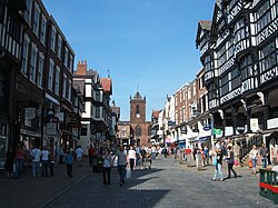 The Chester Rows & St Peter's Church | |
| Location | |
| Grid reference: | SJ405665 |
| Location: | 53°11’33"N, 2°53’28"W |
| Data | |
| Population: | 77,040 |
| Post town: | Chester |
| Postcode: | CH1-4 |
| Dialling code: | 01244 |
| Local Government | |
| Council: | Cheshire West & Chester |
| Parliamentary constituency: |
City of Chester |
Chester is a city and county town of Cheshire. It is an ancient and historic city, standing on the River Dee, close to the border with Flintshire and by the root of the Wirral Peninsula. Chester is home to some 77,040 and is one of the largest towns of the county. Chester received letters patent creating it a city in 1541.
Chester was founded as a Roman fort with the name Deva Victrix in the year 79 by the Roman Legio II Adiutrix during the reign of the Emperor Vespasian. Its four main roads, Eastgate, Northgate, Watergate and Bridge, follow routes laid out at this time – almost 2,000 years ago. One of the three main Roman army bases, Deva later became a major settlement in the Roman province of Britannia.
Chester has many mediæval buildings, but some of the black-and-white buildings within the city centre are Victorian restorations.[1] Chester is one of the best preserved walled cities in the British Isles. Apart from a 330-foot section, the Grade-I-listed walls are almost complete.[2]
The Industrial Revolution brought railways, canals, and new roads to the city, which saw substantial expansion and development. Chester Town Hall and the Grosvenor Museum are examples of the grand Victorian architecture of this period.
Lie of the land
Chester lies at the southern end of a two-mile Triassic sandstone ridge that rises to a height of 138 feet within a natural S-bend in the River Dee, before the course was altered in the 18th century.
The eastern and northern part of Chester consisted of heathland and forest. The western side towards the Dee Estuary was marsh and wetland habitats.
Name of the city
The Romans called the town Deva or Deva Victrix after a local goddess. It appears in Nennius's list of cities as Cair ligion. Chester fell to the English in the 7th century and became known as Legaceaster, while in Welsh it was known as Deverdoeu (a name last found in the late 12th century) or Caerlleon ("city of the legions"), a name identical with that of the Roman fortress Isca Augusta at the other end of the Marches at Caerleon in Monmouthshire. By the 11th century the English name had become "Ceaster". The modern Welsh name likewise is Caer.
From the 14th century to the 18th century the city's prominent position in north-western England meant that it was commonly also known as Westchester. This name was used by Celia Fiennes when she visited the city in 1698.[3]
Sights around the city
The more remarkable landmarks in the city are the city walls, the Rows, the Cathedral and the city's black-and-white architecture.
City walls
The walls encircle the bounds of the mediæval city and constitute the most complete city walls in Britain,[2] the full circuit measuring nearly two miles.[4] The only break in the circuit is in the south-west section in front of County Hall.[5] A footpath runs along the top of the walls, crossing roads by bridges over Eastgate, Northgate, St Martin's Gate, Watergate, Bridgegate, Newgate, and the Wolf Gate, and passing a series of structures, namely Phoenix Tower (or King Charles' Tower), Morgan's Mount, the Goblin Tower (or Pemberton's Parlour), and Bonewaldesthorne's Tower with a spur leading to the Water Tower, and Thimbleby's Tower.[6]
On Eastgate is Eastgate Clock which is said to be the most photographed clock in England after Big Ben in Westminster.[7]
The Rows
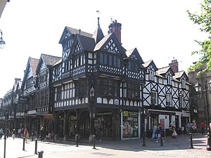
The Rows are unique in Britain.[8][9] They consist of buildings with shops or dwellings on the lowest two storeys. The shops or dwellings on the ground floor are often lower than the street and are entered by steps, which sometimes lead to a crypt-like vault. Those on the first floor are entered behind a continuous walkway, often with a sloping shelf between the walkway and the railings overlooking the street.[10] Much of the architecture of central Chester looks mediæval and some of it is but by far the greatest part of it, including most of the black-and-white buildings, is Victorian, a result of what Pevsner termed the "black-and-white revival".[11]
Roman remains
In parts of the city Roman remains survive, particularly in the basements of some of the buildings and in the lower parts of the northern section of the city walls.[12]
The most important Roman feature is the amphitheatre just outside the walls which is undergoing archaeological investigation.
Roman artifacts are on display in the Roman Gardens which run parallel to the city walls from Newgate to the River Dee, where there is also a reconstructed hypocaust system. An original hypocaust system can be seen in the basement of the Spudulike on Bridge Street, which is open to the public.[13]
Prominent buildings
Chester Town Hall was opened in 1869. It is in Gothic Revival style and has a tower and a short spire.[14]
Chester Castle stands as the most important surviving building of the mediæval city. The Agricola Tower is a the most impressive original structure. Much of the rest of the castle has been replaced by the neoclassical county court and its entrance, the Propyleum.
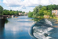
Chester Weir stands in the River Dee, and was built in the 11th century.
The Old Dee Bridge, dating from the 13th century, crosses the river. The Grosvenor Bridge of 1832, and Queen's Park suspension bridge (for pedestrians) cross it elsewhere. To the south-west of the city the River Dee curves towards the north. The area between the river and the city walls here is known as the Roodee, and contains Chester Racecourse which holds a series of horse races and other events.
The Shropshire Union Canal runs to the north of the city and a branch leads from it to the River Dee.[15]
The Chester Shot Tower is the highest structure in Chester.[16]
Churches
The Cathedral
Chester Cathedral was formerly the church of St Werburgh's Abbey. Its architecture dates back to the Norman era, with additions made most centuries since. A series of major restorations took place in the 19th century and in 1975 a separate bell tower was opened. The elaborately carved canopies of the choirstalls are considered to be one of the finest in the country. Also in the cathedral is the shrine of St Werburgh.
To the north of the cathedral are the former monastic buildings.[17]
Other churches etc
- St John's (St John the Baptist) is the oldest church in the city. It lies outside the city walls and was at one time the cathedral church. The church was shortened after the dissolution of the monasteries and ruins of the former east end remain outside the church. Much of the interior is in Norman style and this is considered to be the best example of 11th–12th century church architecture in Cheshire.[18]
- Chester High Cross stands at the intersection of the former Roman roads and to the north of St Peter's.
- St Peter's is a small church of St Peter’s which is now in use as an ecumenical centre.
- Redundant churches:
Culture and leisure
The major museum in Chester is the Grosvenor Museum which includes a collection of Roman tombstones and an art gallery. Associated with the museum is 20 Castle Street in which rooms are furnished in different historical styles.[22]
The Dewa Roman Experience has hands-on exhibits and a reconstructed Roman street. And one of the blocks in the forecourt of the castle houses the Cheshire Military Museum.[23]
The major public park in Chester is Grosvenor Park, named after the Grosvenor family of the Dukes of Westminster who hold much of the land around the city.[24]
On the south side of the River Dee, in Handbridge, is Edgar's Field, another public park,[25] which contains Minerva's Shrine, a Roman shrine to the goddess Minerva.[26] A war memorial to those who died in the world wars is in the town hall and it contains the names of all Chester servicemen who died in the First World War.[27]
Guides for visitors
Chester Visitor Centre, opposite the Roman Amphitheatre, issues a leaflet giving details of tourist attractions. Those not covered above include cruises on the River Dee and on the Shropshire Union Canal, and guided tours on an open-air bus.[28] The river cruises start from a riverside area known as the Groves, which contains seating and a bandstand.[29] A series of festivals is organised in the city, including mystery plays, a summer music festival and a literature festival.[30] The local council has produced a series of leaflets for self-guided walks.[31] Tourist Information Centres are found in the town hall and in Chester Visitor Centre.[32]
History
Roman
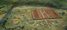
The Romans founded the city of Chester as Deva Victrix in the 70s AD in the land of the Cornovii tribe, according to ancient cartographer Ptolemy.[33] It was a fortress town key to the Roman expansion northward.[34] The name Deva came either after the goddess of the Dee,[35] or directly from the British name for the river.[36] The 'victrix' part of the name was taken from the title of the Legio XX Valeria Victrix which was based at Deva.[37] The fortress was larger than other fortresses in Britannia built around the same time at York (Eboracum) and Caerleon (Isca Augusta);[38] which has led to the suggestion that the fortress, rather than London (Londinium), was intended to become the capital of Britannia Superior.[39] The civilian amphitheatre, built in the 1st century, could seat between 8,000 and 10,000 people.[40] It is the largest known military amphitheatre in Britain,[41] and its remains are now a Scheduled Monument.[42] The Minerva Shrine in the Roman quarry is the only rock cut Roman shrine still in place in Britain.[43]
Deva was garrisoned by the legion until at least the late 4th century.[44] Although the army had abandoned the fortress by 410 when the Romans retreated from Britannia,[45] the civilian settlement continued and its occupants probably continued to use the fortress and its defences as protection from raiders from the Irish Sea.[44]
Mediæval period
The English captured Chester from the Britons after the decisive Battle of Chester in the early 7th century, and it became an English town. This battle marked the point at which the expanding Anglo-Saxons first reached as far as the west coast of Britain. Thus the native Britons were divided in two, north and south, from which Wales and Strathclyde developed separately.
Chester developed as a wealthy merchant town in the Middle Ages.
Industrial history
Chester played a significant part in the Industrial Revolution which began in the north-west of England in the latter part of the 18th century. The village of Newtown, at the north-east of the city and bounded by the Shropshire Union Canal, was at the heart of this industry. The large Chester Cattle Market and that at Newtown thrived and the two railway stations and the canal brought business.
Twentieth century and beyond
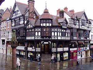

A considerable amount of land in Chester is owned by the Duke of Westminster who owns an estate, Eaton Hall, near the village of Eccleston. The Duke of Westminster is best known for his London properties in Mayfair and his Liverpool properties amongst a wide protfolio.
Grosvenor is the Duke's family name and has given a name to Grosvenor Bridge, the Grosvenor Hotel, and Grosvenor Park amongst others. Much of Chester's architecture dates from the Victorian era, many of the buildings being modelled on the Jacobean half-timbered style and designed by John Douglas, who was employed by the Duke as his principal architect. He had a trademark of twisted chimney stacks, many of which can be seen on the buildings in the city centre.
Douglas designed amongst other buildings the Grosvenor Hotel and the City Baths. In 1911, Douglas' protégé and city architect James Strong designed the then active fire station on the west side of Northgate Street. Another feature of all buildings belonging to the estate of Westminster is the 'Grey Diamonds' – a weaving pattern of grey bricks in the red brickwork laid out in a diamond formation.
Towards the end of the 1939-45 War, a lack of affordable housing meant many problems for Chester. Large areas of farmland on the outskirts of the city were developed as residential areas in the 1950s and early 1960s producing, for instance, the suburb of Blacon. These developments and the bypass built through and around the town centre in 1964 caused much local concern as the physicality and therefore the feel of the city was being dramatically altered. In 1968, a report by Donald Insall[46] in collaboration with authorities and government recommended that historic buildings be preserved in Chester. Consequently, the buildings were used in new and different ways instead of being flattened.[47]
In 1969 the City Conservation Area was designated. Over the next 20 years the emphasis was placed on saving historic buildings, such as The Falcon Inn, Dutch Houses and Kings Buildings.
References
- ↑ Pevsner and Hubbard, pp. 130–131.
- ↑ 2.0 2.1 Morriss, p. 43.
- ↑ "The Illustrated Journeys of Celia Fiennes 1685 - c1712" edited by Christopher Morris
- ↑ Bilsborough, p. 9.
- ↑ "Chester Walls South West Section". Chester City Council. Archived from the original on 2008-04-24. http://web.archive.org/web/20080424065755/http://www.chester.gov.uk/tourism_and_leisure/heritage_trails/chester_city_walls_trail/south_west_section.aspx. Retrieved 15 April 2008.
- ↑ Pevsner and Hubbard, pp. 154–156.
- ↑ "Information Sheet: Eastgate Clock". Chester City Council. Archived from the original on 2007-10-19. http://web.archive.org/web/20071019012722/http://www.chester.gov.uk/tourism_and_leisure-1/culture_and_leisure/grosvenor_museum/information_sheets/eastgate_clock.aspx. Retrieved 16 April 2008.
- ↑ Bilsborough, p. 17.
- ↑ Ward, p. 50.
- ↑ Morriss, pp. 13–14
- ↑ Pevsner and Hubbard, pp. 38–39, 130–131.
- ↑ Pevsner and Hubbard, pp. 133–134
- ↑ "English Heritage Spud-U-Like entry". The Civic Trust. http://www.heritageopendays.org.uk/directory/HOD004011E. Retrieved 18 August 2008.
- ↑ Pevsner and Hubbard, p. 158.
- ↑ "Canal Towpath Trail". Chester City Council. Archived from the original on 2008-05-29. http://web.archive.org/web/20080529122859/http://www.chester.gov.uk/PDF/Heritage-Trail-Canal.pdf. Retrieved 16 April 2008.
- ↑ "Chester Lead Works". Chester City Council. Archived from the original on 2008-05-29. http://web.archive.org/web/20080529122857/http://www.chester.gov.uk/PDF/HeritageBriefing_LeadWorks.pdf. Retrieved 16 April 2008.
- ↑ Pevsner and Hubbard, pp. 135–147
- ↑ "Images of England: Church of St John the Baptist, Chester". English Heritage. http://www.imagesofengland.org.uk/details/default.aspx?pid=1&id=469958. Retrieved 15 April 2008.
- ↑ "Images of England: Heritage centre". English Heritage. http://www.imagesofengland.org.uk/details/default.aspx?pid=1&id=470097. Retrieved 15 April 2008.
- ↑ "Images of England: St Mary's Centre". English Heritage. http://www.imagesofengland.org.uk/details/default.aspx?pid=1&id=470377. Retrieved 15 April 2008.
- ↑ Pevsner and Hubbard, pp. 152–153
- ↑ "The Grosvenor Museum". Chester City Council. Archived from the original on 2008-04-20. http://web.archive.org/web/20080420101056/http://www.chester.gov.uk/tourism_and_leisure-1/culture_and_leisure/grosvenor_museum.aspx. Retrieved 16 April 2008.
- ↑ Dewa Roman Experience home page
- ↑ "Grosvenor Park". Chester City Council. http://www.chester.gov.uk/grosvenor_park.aspx. Retrieved 16 April 2008.
- ↑ "Discover Edgar's Field". Chester City Council. Archived from the original on 2008-05-24. http://web.archive.org/web/20080524182041/http://www.chester.gov.uk/tourism_and_leisure/heritage_trails/discover_edgars_field.aspx. Retrieved 16 April 2008.
- ↑ "Minerva's Shrine". Chester City Council. Archived from the original on 2007-09-27. http://web.archive.org/web/20070927213557/http://www.chester.gov.uk/tourism_and_leisure/heritage_trails/discover_edgars_field/minerva_shrine.aspx. Retrieved 16 April 2008.
- ↑ "War Memorial, Town Hall, Chester, Cheshire.". Carl's Cam. http://www.carlscam.com/gazet.htm. Retrieved 16 April 2008.
- ↑ "Chester Attractions". Chester Visitor Centre. Archived from the original on 2008-05-29. http://web.archive.org/web/20080529122908/http://www.chester.gov.uk/PDF/Tourism_Chester_Attractions_Booklet.pdf. Retrieved 16 April 2008.
- ↑ "Recreation and Leisure". Chester City Council. Archived from the original on 2008-03-31. http://web.archive.org/web/20080331134420/http://www.chester.gov.uk/advice_and_information/business_help_and_advice/doing_business_in_chester/an_ideal_location/recreation_and_leisure.aspx. Retrieved 17 April 2008.
- ↑ "Festivals and Events". Chester City Council. Archived from the original on 2008-04-11. http://web.archive.org/web/20080411025705/http://www.chester.gov.uk/tourism_and_leisure-1/festivals_and_events.aspx. Retrieved 16 April 2008.
- ↑ "Heritage Trails". Chester City Council. Archived from the original on 2008-04-24. http://web.archive.org/web/20080424092321/http://www.chester.gov.uk/tourism_and_leisure-1/heritage_trails.aspx. Retrieved 17 April 2008.
- ↑ "Tourist Information Centre". Chester City Council. Archived from the original on 2008-04-04. http://web.archive.org/web/20080404123608/http://www.chester.gov.uk/tourism_and_leisure/visit_chester/tourist_information_centres.aspx. Retrieved 17 April 2008.
- ↑ Ptolemy (1992), Book II Chapter 2
- ↑ Mason (2001), p. 42.
- ↑ Salway, P. (1993) The Oxford Illustrated History of Roman Britain. ISBN CN 1634
- ↑ C.P. Lewis, A.T. Thacker (Editors) (2003). "A History of the County of Chester: Volume 5 part 1". British-history.ac.uk. http://www.british-history.ac.uk/report.aspx?compid=19182#n6. Retrieved 10 March 2008.
- ↑ Mason (2001), p. 128.
- ↑ Carrington (2002), p. 33-35.
- ↑ Carrington (2002), p. 46.
- ↑ Spicer, Graham (9 January 2007). "Revealed: New discoveries at Chester's Roman amphitheatre". Culture24.org.uk. http://www.culture24.org.uk/history+%2526+heritage/time/roman/art42592. Retrieved 16 December 2009.
- ↑ Carrington (2002), p. 54-56.
- ↑ "Chester Amphitheatre". Pastscape.org.uk. http://www.pastscape.org.uk/hob.aspx?hob_id=69224&search=all&criteria=chester%20amphitheatre. Retrieved 10 March 2008.
- ↑ "Roman shrine to Minerva". Images of England. http://www.imagesofengland.org.uk/details/default.aspx?pid=1&id=469762. Retrieved 15 March 2008.
- ↑ 44.0 44.1 Lewis, C.P.; Thacker, A.T. (2003). "Roman Chester". A History of the County of Chester: Volume 5 part 1: the City of Chester: General History and Topography (British-History.ac.uk): 9–15. http://www.british-history.ac.uk/report.aspx?compid=19183. Retrieved 15 March 2008.
- ↑ Mason (2001), p. 209-210.
- ↑ "Donald Insall Associates, official website". http://www.donaldinsallassociates.co.uk/. Retrieved 21 November 2007.
- ↑ "Chester Travel Guide and Travel Information". Lonely Planet. http://www.lonelyplanet.com/worldguide/destinations/europe/england/chester?v=print.
- Bilsborough, Norman (1983). The Treasures of Cheshire. Swinton: North West Civic Trust. ISBN 0901347353.
- Carrington, P (ed.) (2002). Deva Victrix: Roman Chester Re-assessed. Chester: Chester Archaeological Society. ISBN 095070749X.
- Emery, G (1998). Chester inside out. Chester, United Kingdom: Gordon Emery. ISBN 1872265928.
- Emery, G; Penney, M. (1999). Curious Chester: Portrait of an English city over two thousand years. Chester, United Kingdom: Gordon Emery. ISBN 1872265944.
- Emery, G (2002). Chester electric lighting station: From steam and hydro–The illuminating story of Chester streetlighting and Britain's first rural electricity supply. Chester, United Kingdom: Gordon Emery. ISBN 1872265480.
- Emery, G (2003). The Chester guide: England's walled city, Roman remains, museums, attractions, River Dee, shopping on the medieval rows, cathedral, access. Chester, United Kingdom: Gordon Emery. ISBN 1872265898.
- Emery, G; Shuttleworth, S.; Kavanagh, T.; Taylor, G.; Buss, R.; Stephens, R. (1999). The old Chester canal: A History and Guide. Chester, United Kingdom: Gordon Emery.
- Lewis, P.R. (2007). Disaster on the Dee: Robert Stephenson's Nemesis of 1847. Stroud, United Kingdom: Tempus Publishing. ISBN 9780752442662.
- Marshall, A. E. (1966). Myths and Legends of Chester. Chester, United Kingdom: Chester blind welfare society. ISBN 095117830X.
- Mason, David J.P. (2001). Roman Chester: City of the Eagles. Stroud: Tempus Publishing Ltd. ISBN 0-7524-1922-6.
- Morriss, Richard K. (1993). The Buildings of Chester. Stroud: Alan Sutton. ISBN 0-7509-0255-8.
- Morton, H. V. (1930). In Search of England. London: Methuen. ISBN 0416344801.
- Pevsner, Nikolaus; Edward Hubbard (2003) [1971]. The Buildings of England: Cheshire. New Haven & London: Yale University Press. ISBN 0300095880.
- Place, G.W. (1994). The Rise and Fall of Parkgate, Passenger Port for Ireland, 1686-1815 (Chetham Society). Lancaster, United Kingdom: Carnegie Publishing Limited. ISBN 1859360238.
- Ptolemy (1992). The Geography. Dover Publications Inc.. ISBN 0486268969.
- Wall, B. (1992). Tales of Chester. Shropshire, United Kingdom: S. B. Publications. ISBN 1857700066.
- Ward, Simon (2009). Chester: A History. Chichester: Phillimore. ISBN 9781860774997.
- Wilding, R. (1997). Miller of Dee:The story of Chester mills and millers, their trades, and wares, the weir, the water engine, and the salmon. Chester, United Kingdom: Gordon Emery. ISBN 1872265952.
- Wilding, R. (2003). Death in Chester: Roman Gravestones, Cathedral Burials, Martyrs, Witches, the Plague, Horrible Hangings, Gruesome Deaths and Ghostly Goings-on. Chester, United Kingdom: Gordon Emery. ISBN 1872265448.
Outside links
- Read a detailed historical record about the Fortress Baths, Chester
- 'Chester: A Virtual Stroll Around the Walls'
- Reprint of paper on Dee bridge disaster
- Chester Scenics (Images of Chester by Night and Day)
- Chester-a portrait (Images and information about Chester)
- Chester Wall Documentary
| Cities in the United Kingdom |
|---|
|
Aberdeen • Armagh • Bangor (Caernarfonshire) • Bangor (County Down) • Bath • Belfast • Birmingham • Bradford • Brighton and Hove • Bristol • Cambridge • Canterbury • Cardiff • Carlisle • Chelmsford • Chester • Chichester • Colchester • Coventry • Derby • Doncaster • Dundee • Dunfermline • Durham • Ely • Edinburgh • Exeter • Glasgow • Gloucester • Hereford • Inverness • Kingston upon Hull • Lancaster • Leeds • Leicester • Lichfield • Lincoln • Lisburn • Liverpool • City of London • Londonderry • Manchester • Milton Keynes • Newcastle upon Tyne • Newport • Newry • Norwich • Nottingham • Oxford • Perth • Peterborough • Plymouth • Portsmouth • Preston • Ripon • Rochester • Salford • Salisbury • Sheffield • Southampton • St Albans • St Asaph • St David's • Southend-on-Sea • Stirling • Stoke-on-Trent • Sunderland • Swansea • Truro • Wakefield • Wells • Westminster • Winchester • Wolverhampton • Worcester • Wrexham • York |