Tan Hill, Wiltshire
| Tan Hill | |||
| Wiltshire | |||
|---|---|---|---|
 The Wansdyke on Tan Hill | |||
| Range: | Marlborough Downs | ||
| Summit: | 965 feet; SU081646 51°22’52"N, 1°53’1"W | ||
Tan Hill is a hill amongst the Marlborough Downs in Wiltshire, and almost the highest point in that county, being pipped to the title of 'county top' only by neighbouring Milk Hill. It is found to the north of Allington in the parish of All Cannings.
The summit is 965 feet above sea level and it was long thought to be the highest hill in the county. On 23 August 2009, the BBC television programme Countryfile featured an item on analysis by Ordnance Survey to determine whether Milk or Tan Hill is in fact the highest. It was confirmed that Milk Hill is ten inches higher than Tan Hill.[1]
Along the north side of Tan Hill runs a section of The Wansdyke, a long earthen rampart which runs east to west across Somerset and Wiltshire.[2]
Hill figure and stone circle
Formerly, Tan Hill had a hill figure of a white horse, sometimes called the Tan Hill Donkey because of its notably large head. Author Kathleen Wiltshire, in her book Wiltshire Folklore, published in 1975, described the figure being still partly visible "on Tan Hill, though the legs have become quite overgrown... This pony or donkey is 75 feet from nose to tail, which stretches down much like that of the Uffington horse, and its head is very large."[3][4] She went on to write that in "the 'valley' between Tan Hill and Rybury Camp stands a miniature stone circle of nine upright sarsen stones about four feet in height, in the centre of which lies a prostrate stone, about the length of a man. A pathway leads up to the 'donkey' from the circle."[4] The figure subsequently became known as Mrs Wiltshire's Donkey.[5] Whilst Wiltshire placed the hill figure on Tan Hill, another later source described it on a "medium steep slope between Tan Hill and Ryebury Camp".[5]
The white horse was described as "overgrown" in 1964, with its legs having disappeared.[6] In March 2002, local research by 'wiltshirewhitehorses.org.uk' confirmed the horse's existence and established the location of the stone circle, whose position had been misleadingly described in Wiltshire's book.[4] The stone circle had been previously noted during an archaeological field investigation in 1973, but was thought likely to be a modern arrangement of field clearance boulders rather than a prehistoric monument.[6] The path to the horse from the circle still existed in 2002, but no trace of the horse remained.[4] However, in November 2004, vegetation and light conditions allowed the horse's shape to be discerned.[5]
In folklore, it was said locally that when the horse heard All Cannings' church clock strike midnight it went down to a dewpond above Cannings Cross to drink. One night it was supposedly so thirsty that it drank the pond dry, even though a dewpond is said never to dry up.[7]
Views
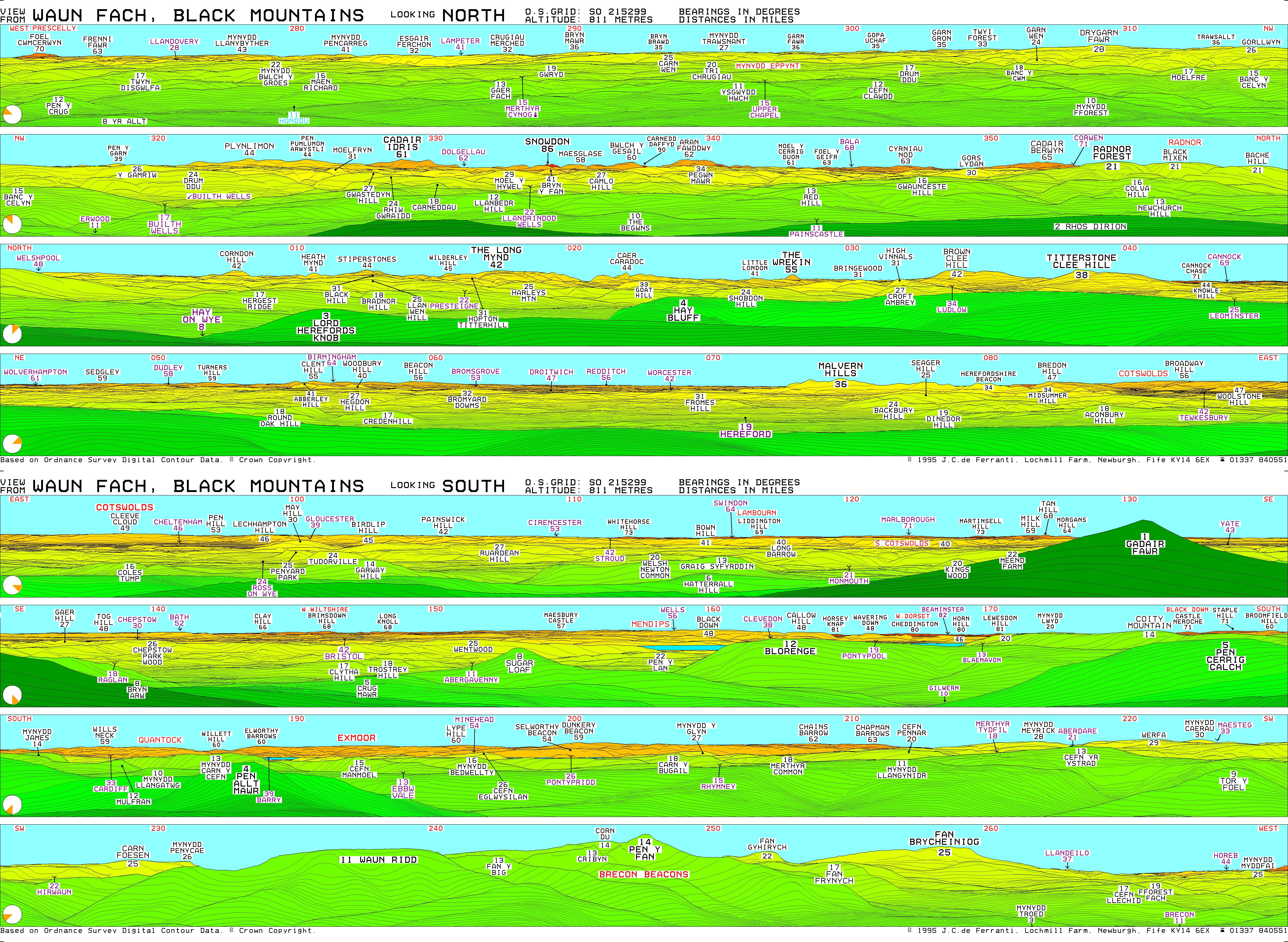
Views are extensive from Tan Hill, ranging from Cheesefoot Head near Winchester to the south-east to, in clear weather, the Black Mountains in Wales to the north-west, making this, alongside neighbouring Milk Hill, one of the most south-easterly points in Britain from which high mountain country can be sighted.[8] Salisbury Plain and, further away, the Mendips and Cotswolds are also clearly visible.
According to computer-generated panoramas it should be possible to sight Pen y Fan, highest point of the Brecon Beacons, in exceptionally clear weather.[9]
References
- ↑ Countyfile, BBC One, 23 August 2009
- ↑ National Heritage List 1017288: Section of Wansdyke and associated monuments from east of The Firs to the eastern side of Tan Hill (Scheduled ancient monument entry)
- ↑ Wiltshire, Kathleen (1975). Wiltshire Folklore. Compton Press Ltd. ISBN 0859550168.
- ↑ 4.0 4.1 4.2 4.3 "Wiltshire White Horses: The Tan Hill white horse". http://www.wiltshirewhitehorses.org.uk/tanhill.html.
- ↑ 5.0 5.1 5.2 Hows, Mark. "Tan Hill Donkey". http://www.hows.org.uk/personal/hillfigs/lost/donkey.htm. Retrieved 29 August 2020.
- ↑ 6.0 6.1 National Monuments Record: No. 216086 – @
- ↑ "Folklore and legends". http://www.wiltshirewhitehorses.org.uk/folklore.html. Retrieved 29 August 2020.
- ↑ "Panorama diagram". http://www.viewfinderpanoramas.org/panoramas/WAL/WAUNFACH.GIF.
- ↑ "Panorama diagram". http://www.viewfinderpanoramas.org/panoramas/WAL/PENYFAN-S.gif.