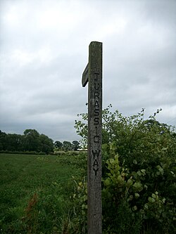
Jurassic Way

The Jurassic Way is an 88-mile designated and signed long-distance footpath that connects Banbury at the border of Oxfordshire and Northamptonshire with Stamford just across the border in Lincolnshire.[1]
Almost the whole of the route is in Northamptonshire, on the Jurassic limestone ridge in the north of that county. Its western end is in Oxfordshire but within yards of the county boundary (here marked by the River Cherwell) and at its eastern end it crosses the River Welland into Lincolnshire on the Town Meadows at the edge of the town, running in the latter county for a little under a mile.
The trail goes near to the Oxford and Grand Union Canals, past the Great Central Railway's Catesby Tunnel and viaduct, the River Welland, the 82-arch viaduct at Harringworth, and Rockingham Castle.[2]
The trailheads are:
- Banbury, Oxfordshire
52°3’25"N, 1°19’48"W, by the Oxford Canal and the county border - Stamford, Lincolnshire
52°39’2"N, 0°28’51"W, in the Town Meadows
Connections
It connects with these long-distance footpaths:
Outside links
- Location map: 52°25’26"N, 1°2’35"W
- Further details
- Pictures of The Jurassic Way and the area on Geograph.co.uk
- Catesby Tunnel & Viaduct at The Warwickshire Railways site
References
- "Long distance routes". Rutland county council. http://www.rutland.gov.uk/transport_and_streets/public_rights_of_way/long_distance_routes.aspx. Retrieved 2013-03-20.