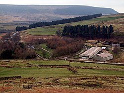
Crowden, Cheshire
| Crowden | |
| Cheshire | |
|---|---|
 Crowden from the northeast | |
| Location | |
| Grid reference: | SK071992 |
| Location: | 53°29’24"N, 1°53’38"W |
| Data | |
| Post town: | Glossop |
| Postcode: | SK13 |
| Dialling code: | 01457 |
| Local Government | |
| Council: | High Peak |
| Parliamentary constituency: |
High Peak |
Crowden, or Crowden-in-Longdendale is a Cheshire hamlet high in Longdendale, in the High Peak of the Peak District. It stands 4½ miles up the dale from Tintwistle, six miles northeast of Glossop, Derbyshire and 5½ miles southwest of Holme, Yorkshire. It is the highest village in Cheshire, standing beneath the vast, peaty mass which culminates in Black Hill, the county's highest point on the Yorkshire border.
Crowden lies on the trans-Pennine A628 road connecting south Lancashire with the great cities of the West Riding of Yorkshire. It also lies very close to the Pennine Way long distance footpath, on which it is traditionally the first-night stop after a start from Edale, and has a youth hostel.[1]
The Torside Reservoir is to the south of Crowden. An army rifle range was situated at Crowden in the 1950s and 1960s.
The hamlet was previously served by Crowden railway station on the Woodhead Line between the cities of Manchester and Sheffield, but the station closed on 4 February 1957.
References
Outside links
| ("Wikimedia Commons" has material about Derbyshire Crowden, Cheshire) |