Difference between revisions of "St Botolph's Church, Botolphs"
(Created page with "{{Infobox church |name=St Botolph's Church |county=Sussex |picture=St Botolph,s Church from the west..jpg |picture caption=St Botolph's Church from the west |os grid ref=TQ193...") |
|||
| Line 29: | Line 29: | ||
The river Adur was originally navigable as far as Bramber; but the sea began to recede in about 1350, and the river silted up, after which the bridge at Botolphs fell into disuse and the village population declined. The crossing point had apparently been in use for about 1,000 years (as suggested by the Roman rubble found nearby), and when it was lost the village could no longer thrive.<ref name=c106/> In 1526 Botolphs was incorporated into Bramber parish.<ref name=v1/><ref name=c106/> Structurally, the church expanded and contracted over the centuries in line with the changing population. In its original form, it was an aisleless building with nave and chancel.<ref name=v1/> In the 13th century, a tower was added;<ref name=p113/> and in about 1250 an aisle was added to the north side, separated from the nave by an arcade of three bays.<ref name=p113/><ref name=a732/> The chancel was altered and new windows were inserted in the 14th century. The tower was equipped with a peal of three bells in 1536.<ref name=v1/> The aisle, which apparently housed a shrine to St Botolph, St Peter and Mary,<ref name=a732/> became dilapidated by the late 18th century as the population fell; it had been demolished by 1830,<ref name=v1/> leaving the three blank arches of the arcade on the north wall.<ref name="Salter87">{{Harvnb|Salter|2000|p=87.}}</ref> | The river Adur was originally navigable as far as Bramber; but the sea began to recede in about 1350, and the river silted up, after which the bridge at Botolphs fell into disuse and the village population declined. The crossing point had apparently been in use for about 1,000 years (as suggested by the Roman rubble found nearby), and when it was lost the village could no longer thrive.<ref name=c106/> In 1526 Botolphs was incorporated into Bramber parish.<ref name=v1/><ref name=c106/> Structurally, the church expanded and contracted over the centuries in line with the changing population. In its original form, it was an aisleless building with nave and chancel.<ref name=v1/> In the 13th century, a tower was added;<ref name=p113/> and in about 1250 an aisle was added to the north side, separated from the nave by an arcade of three bays.<ref name=p113/><ref name=a732/> The chancel was altered and new windows were inserted in the 14th century. The tower was equipped with a peal of three bells in 1536.<ref name=v1/> The aisle, which apparently housed a shrine to St Botolph, St Peter and Mary,<ref name=a732/> became dilapidated by the late 18th century as the population fell; it had been demolished by 1830,<ref name=v1/> leaving the three blank arches of the arcade on the north wall.<ref name="Salter87">{{Harvnb|Salter|2000|p=87.}}</ref> | ||
| − | A timber-framed vicarage existed by 1615. | + | A timber-framed vicarage existed by 1615. It may date from the 14th century, and the building still stands next to the church—albeit with structural alteration. It is a Grade II listed building.<ref>{{NHLE|1027460|Vicarage Cottage, Botolphs|grade=II}}</ref> |
==Architecture, fittings and setting== | ==Architecture, fittings and setting== | ||
| Line 78: | Line 78: | ||
{{Refend}} | {{Refend}} | ||
| − | [[Category:Standing Anglo-Saxon churches|Saint Botolph's Church | + | [[Category:Standing Anglo-Saxon churches|Botolphs Saint Botolph's Church]] |
Latest revision as of 13:35, 21 March 2024
| St Botolph's Church | |
|
Botolphs, Sussex | |
|---|---|
| Status: | Parish church |
 St Botolph's Church from the west | |
| Church of England | |
| Diocese of Chichester | |
| Location | |
| Grid reference: | TQ19360925 |
| Location: | 50°52’14"N, 0°18’18"W |
| History | |
| Built Late 11th century | |
| Saxon/Norman | |
| Information | |
| Website: | www.3bsparish.co.uk |
The Church of St Botolph in Botolphs, Sussex, is a Saxon church in the valley of the River Adur, and now part of the Church of England parish of Beeding and Bramber with Botolphs. An earlier dedication to St Peter de Vetere Ponte (St Peter of the Old Bridge) is now lost, like the bridge over the Adur from which it took this name.[1] St Andrew's is a Grade I listed building.[2]
The church serves a mostly depopulated hamlet, Botolphs, in the south of Sussex. The church has fragments of mediæval wall paintings. The architectural historian Ian Nairn comments that the Jacobean pulpit is "notable in a county which is poor in 17th century fittings".[3]
History
The parish of Botolphs came into existence in the Saxon era as one of several long, narrow divisions of land on the southern slopes of the South Downs near the River Adur, which reached the English Channel at the port of Shoreham. Like neighbouring Beeding and Bramber, Botolphs' territory stretched for about 2.0 miles (3.2 km) from west to east.[4][5] At the time of the Domesday Book in 1086, the manor of Hanyngedune was known; it was first named in 956, when King Eadwig granted it away by charter, and the area it covered was identical to the later parish of Botolphs.[4][6]
Two settlements grew up in the parish of Annington: one around the manor house and its farm,[3][4] and a second clustered around the church. The latter settlement was known as Old Bridge before acquiring the name Botolphs, and both the name and archaeological evidence (in the form of Roman-era masonry found in the fields) suggest that the church was built near the site of the now vanished bridge over the river.[4][7][8]
The Domesday survey mentioned a church at Annington and architectural evidence suggests that St Botolph's Church is of Saxon origin, confirming that only one church served the parish,[3][9] rather than each settlement having its own place of worship as was once believed.[6] The dedication to St Botolph is thought to be original; but around the time of the Norman conquest the church was officially rededicated to St Peter de Vetere Ponte (meaning St Peter of the Old Bridge). In 1254, the dedication to St Botolph reappeared in print, and the two names were used interchangeably for a period as use of the old name was maintained by locals.[6] By the 15th century, the newer dedication to St Peter fell out of use.[4] Another historic dedication, to St Mary, has also been suggested.[8] The existence of another St Peter's Church at nearby Beeding has been suggested as a reason for the dedication reverting to St Botolph.[10]

The river Adur was originally navigable as far as Bramber; but the sea began to recede in about 1350, and the river silted up, after which the bridge at Botolphs fell into disuse and the village population declined. The crossing point had apparently been in use for about 1,000 years (as suggested by the Roman rubble found nearby), and when it was lost the village could no longer thrive.[10] In 1526 Botolphs was incorporated into Bramber parish.[4][10] Structurally, the church expanded and contracted over the centuries in line with the changing population. In its original form, it was an aisleless building with nave and chancel.[4] In the 13th century, a tower was added;[3] and in about 1250 an aisle was added to the north side, separated from the nave by an arcade of three bays.[3][6] The chancel was altered and new windows were inserted in the 14th century. The tower was equipped with a peal of three bells in 1536.[4] The aisle, which apparently housed a shrine to St Botolph, St Peter and Mary,[6] became dilapidated by the late 18th century as the population fell; it had been demolished by 1830,[4] leaving the three blank arches of the arcade on the north wall.[11]
A timber-framed vicarage existed by 1615. It may date from the 14th century, and the building still stands next to the church—albeit with structural alteration. It is a Grade II listed building.[12]
Architecture, fittings and setting

St Botolph's Church is in "a peaceful spot"[8] next to the River Adur, although the former Beeding Cement Works and the Shoreham–Horsham railway line were both a short distance away on the other side of the river (both have ceased operating).[8] Writing in 1932, one historian noted that interest in the church and its similarly isolated neighbour at Coombes had been reinvigorated by the building of a new road along the river between Steyning and the coast, which encouraged visitors to come to the "little lost Down churches".[1] The church was less well regarded in the Victorian era: one 19th-century writer dismissed it as "small and uninteresting".[8] Ian Nairn considered it "simple and mellow",[3] while others have praised the "clean lines [and] perfect setting"[10] of the "small, attractive church".[13]

The nave and chancel are Saxon, but their date is unknown.[9] The nave has long and narrow Saxon proportions of about 55 feet 6 inches long by 17 feet 6 inches wide by the interior measure. At the west end of the south wall is an original round-headed Saxon window. The south doorway is 17th century, with a modern porch.[9] The chancel is about 16 feet long and 10 feet wide on the interior.[14] The chancel arch is of one order with the late Saxon feature of a soffit roll.[15]
The three-bay north aisle added in about 1250[15] had a three-arched arcade. By the early 19th century the arches were filled in and the aisle was demolished—evidence of the declining population and importance of Botolphs, which had become a shrunken mediæval settlement with only a few surviving houses.[4] The remains of the pointed arches are a prominent feature of the north wall.[10]
Traces of the wall paintings were recorded in 1897. When examined in about 1932 they were thought to be from a "Doom" scheme of painting, including depictions of St John and the Virgin Mary with a bishop. However, only a few indistinct patches are visible today.[4]
The pulpit "almost certainly dates from 1630" and was formerly painted blue.[16] It is covered with incised abstract patterns.[3]
One of the three 1536 bells commemorates the old dedication to St Peter with the inscription "Sancte Petre ora pro nobis".
A modern Tapsel gate dating from 2003 links the churchyard to an adjacent civil burial ground, operated by local parish councils..
Pictures
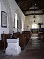
The nave showing the filled-in north arcade.

The Jacobean pulpit.

The church from the north west showing the filled-in arcade, formerly in the north aisle.
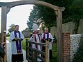
The Bishop of Horsham dedicating the tapsel gate in 2004, with the Rector and the bishop's domestic chaplain.
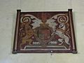
Painting of King Charles I's arms, displayed on the wall inside St Botolph's Church (opposite end from altar)


Outside links
| ("Wikimedia Commons" has material about St Botolph's Church, Botolphs) |
References
- ↑ 1.0 1.1 Arnold 1932, p. 731.
- ↑ National Heritage List 1191927: Church of St Botolph (Grade I listing)
- ↑ 3.0 3.1 3.2 3.3 3.4 3.5 3.6 Nairn & Pevsner 1965, p. 113.
- ↑ 4.00 4.01 4.02 4.03 4.04 4.05 4.06 4.07 4.08 4.09 4.10 Hudson, T. P., ed (1980). "A History of the County of Sussex: Volume 6 Part 1 – Bramber Rape (Southern Part). Botolphs". Victoria County History of Sussex. British History Online. pp. 195–199. https://www.british-history.ac.uk/vch/Sussex/vol6/pt1/pp195-199.
- ↑ Hudson, T. P., ed (1980). "A History of the County of Sussex: Volume 6 Part 1 – Bramber Rape (Southern Part). Bramber: Steyning, Bramber, and Botolphs c.1960 (map)". Victoria County History of Sussex. British History Online. pp. 200–214. https://www.british-history.ac.uk/image.aspx?compid=18252&filename=fig13.gif&pubid=66.
- ↑ 6.0 6.1 6.2 6.3 6.4 Arnold 1932, p. 732.
- ↑ Arnold 1932, pp. 731–732.
- ↑ 8.0 8.1 8.2 8.3 8.4 Wales 1999, p. 36.
- ↑ 9.0 9.1 9.2 Fisher 1970, p. 63.
- ↑ 10.0 10.1 10.2 10.3 10.4 Coppin 2006, p. 106.
- ↑ Salter 2000, p. 87.
- ↑ National Heritage List 1027460: Vicarage Cottage, Botolphs (Grade II listing)
- ↑ Beevers, Marks & Roles 1989, p. 148.
- ↑ Fisher 1970, p. 64.
- ↑ 15.0 15.1 Fisher 1970, p. 65.
- ↑ Allen 2010
- Allen, John (2010), Sussex Parish Churches – Botolphs – St Botolph, http://www.sussexparishchurches.org/content/view/346/33/, retrieved 6 August 2011
- Arnold, H.E.B. (November 1932). "The Church of St Peter de Vetere Ponte on the Adur". Sussex County Magazine (Eastbourne: T.R. Beckett) 6 (11).
- Beevers, David; Marks, Richard; Roles, John (1989). Sussex Churches and Chapels. Brighton: The Royal Pavilion, Art Gallery and Museums. ISBN 0-948723-11-4.
- Coppin, Paul (2006). 101 Mediæval Churches of West Sussex. Seaford: S.B. Publications. ISBN 1-85770-306-5.
- Fisher, E.A. (1970). The Saxon Churches of Sussex. Newton Abbot: David & Charles. ISBN 0-7153-4946-5.
- Hudson, T.P., ed (1980). "Botolphs". A History of the County of Sussex: Volume 6 Part 1: Bramber Rape (Southern Part). Institute of Historical Research/Victoria County History. http://www.british-history.ac.uk/report.aspx?compid=18251.
- Nairn, Ian; Pevsner, Nikolaus (1965). The Buildings of England: Sussex. Harmondsworth: Penguin Books. ISBN 0-14-071028-0.
- Salter, Mike (2000). The Old Parish Churches of Sussex. Malvern: Folly Publications. ISBN 1-871731-40-2.
- Unknown author (n.d.). The Church of St. Botolph. Botolphs: Parish of Beeding and Bramber with Botolphs. p. 7.
- Wales, Tony (1999). The West Sussex Village Book. Newbury: Countryside Books. ISBN 1-85306-581-1.