Castleshaw
| Castleshaw | |
| Yorkshire West Riding | |
|---|---|
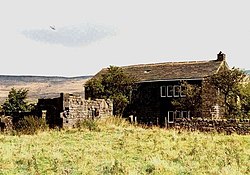
 Farmhouse near Castleshaw | |
| Location | |
| Grid reference: | SE007095 |
| Location: | 53°35’2"N, 2°0’3"W |
| Data | |
| Post town: | Oldham |
| Postcode: | OL3 |
| Dialling code: | 01457 |
| Local Government | |
| Council: | Oldham |
| Parliamentary constituency: |
Oldham East and Saddleworth |
Castleshaw is a scattered hamlet in Saddleworth in the West Riding of Yorkshire. It lies on the moor above Saddleworth's dale-bound villages, amid the Pennines, 2½ miles north of Uppermill and 3 miles west of Marsden.
Castleshaw is best known for the Castleshaw fort, the remains of an ancient Roman fort watching the road over the Pennine fells.
History
A Roman fort once stood here, high on the fell near to the head of the valley. A series of modern mounds and ditches have been laid out to mark the site, on the edge of Castleshaw Upper Reservoir.
The Castleshaw area was once also home to a sanatorium, which is now used as a Youth Training Centre.
| Villages and hamlets of Saddleworth |
|---|
|
Austerlands • Castleshaw • Delph • Denshaw • Diggle • Dobcross • Friezland • Grasscroft • Greenfield • Grotton • Heights • Lydgate • Scouthead • Springhead • Uppermill |