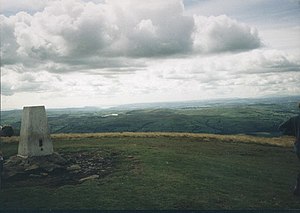
Brant Fell
| Brant Fell | |||
| Yorkshire | |||
|---|---|---|---|

| |||
| Range: | Howgill Fells | ||
| Summit: | 2,218 feet SD667970 | ||
Brant Fell is a hill in the West Riding of Yorkshire, forming much of the bulk of the Howgill Fells, rising to the summit of those hills at The Calf, which stands at 2,218 feet above sea level. Across The Calf runs the border of Westmorland; the name of Brant Fell appears marking the south side of the massif.
Brant Fell has many subsidiary tops and features, including Bram Rigg, whose top (2,205 feet) is just south of The Calf, Calders, a summit complex of Bram Rigg Top and Great Dummacks (2,175 feet), Whiet fell, extending west of The Calf, Cautley Crag, a scree cliff over which tumbles Cautley Spout, east of The Calf.
The town of Sedbergh lies to the south, and a footpath leads north up from the town to the summit, over the subsidiary hills of Winder (1,552 feet) and Arant Haw (1,985 feet).
References
This Mountain or hill article is a stub: help to improve Wikishire by building it up.