Chatburn: Difference between revisions
Created page with "{{infobox town |county=Lancaster |latitude=53.896 |longitude=-2.359 |picture=Chatburn - geograph.org.uk - 38576.jpg |picture caption=Chatburn |population=1,102 |census yea..." |
No edit summary |
||
| Line 16: | Line 16: | ||
'''Chatburn''' is a village and civil parish in eastern [[Lancashire]], adjacent to the border with [[Yorkshire]]. The civil parish derives from the township of the ancient parish of [[Whalley]] and had a population of 1,102 in 2011.<ref>{{cite web|url=http://www.neighbourhood.statistics.gov.uk/dissemination/LeadKeyFigures.do?a=7&b=11121824&c=Chatburn&d=16&e=62&g=6442344&i=1001x1003x1032x1004&m=0&r=1&s=1453299245248&enc=1|title=Civil Parish population 2011|accessdate=20 January 2016}}</ref> It is situated in a hollow between two ridges north-east of [[Clitheroe]], just off the A59 road. It lies near [[Pendle Hill]], which is to the east of the village. The [[River Ribble]] flows to the west of the town, and here forms the county border. The town is approximately 400 feet above sea level. | '''Chatburn''' is a village and civil parish in eastern [[Lancashire]], adjacent to the border with [[Yorkshire]]. The civil parish derives from the township of the ancient parish of [[Whalley]] and had a population of 1,102 in 2011.<ref>{{cite web|url=http://www.neighbourhood.statistics.gov.uk/dissemination/LeadKeyFigures.do?a=7&b=11121824&c=Chatburn&d=16&e=62&g=6442344&i=1001x1003x1032x1004&m=0&r=1&s=1453299245248&enc=1|title=Civil Parish population 2011|accessdate=20 January 2016}}</ref> It is situated in a hollow between two ridges north-east of [[Clitheroe]], just off the A59 road. It lies near [[Pendle Hill]], which is to the east of the village. The [[River Ribble]] flows to the west of the town, and here forms the county border. The town is approximately 400 feet above sea level. | ||
The parish adjoins those of [[Grindleton]], [[Sawley, | The parish adjoins those of [[Grindleton]], [[Sawley, Ribble Valley|Sawley]], [[Rimington]], [[Downham]], [[Worston]], [[Clitheroe]] and [[West Bradford]]. | ||
==History== | ==History== | ||
Latest revision as of 13:36, 21 September 2017
| Chatburn | |
| Lancashire | |
|---|---|
 Chatburn | |
| Location | |
| Grid reference: | SD765445 |
| Location: | 53°53’46"N, 2°21’32"W |
| Data | |
| Population: | 1,102 (2011) |
| Post town: | Clitheroe |
| Postcode: | BB7 |
| Dialling code: | 01200 |
| Local Government | |
| Council: | Ribble Valley |
| Parliamentary constituency: |
Ribble Valley |
Chatburn is a village and civil parish in eastern Lancashire, adjacent to the border with Yorkshire. The civil parish derives from the township of the ancient parish of Whalley and had a population of 1,102 in 2011.[1] It is situated in a hollow between two ridges north-east of Clitheroe, just off the A59 road. It lies near Pendle Hill, which is to the east of the village. The River Ribble flows to the west of the town, and here forms the county border. The town is approximately 400 feet above sea level.
The parish adjoins those of Grindleton, Sawley, Rimington, Downham, Worston, Clitheroe and West Bradford.
History
The village itself can be dated back to Anglo-Saxon times; it takes its name from one of the most distinguished characters of that time, St Chad, and having a brook (or burn) hence the name. The village sits outside the Forest of Bowland and was never considered part of the ancient Lordship of Bowland.
A feature of the village is the spire of the parish church, which was erected around 1838. The steeple was struck by lightning in 1854, but was rebuilt in the same year.
Chatburn railway station was closed in 1962 before the report of Dr Beeching.
Bold Venture lime works and quarry provided much employment for villagers for many years. It was owned by Dixon Robinson from 1837,[2] he also built the Pendle Hotel[3] and Black Bull public houses[4]
Parts of the village and surroundings featured in the 1961 film Whistle Down the Wind starring Hayley Mills and children from Chatburn Primary School.
Media gallery
-
 Surviving part of Chatburn Old Road
 -
 Christ Church
 -
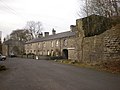 Bold Venture Cottages.
 -
 Black Bull Inn
 -
 Brown Cow public house
 -
 River Ribble with Pendle Hill in the background


References
- ↑ "Civil Parish population 2011". http://www.neighbourhood.statistics.gov.uk/dissemination/LeadKeyFigures.do?a=7&b=11121824&c=Chatburn&d=16&e=62&g=6442344&i=1001x1003x1032x1004&m=0&r=1&s=1453299245248&enc=1. Retrieved 20 January 2016.
- ↑ National archives DDX 28/295
- ↑ Blackburn Standard 14/4/1852
- ↑ Blackburn Standard 11/2/1857
Outside links
| ("Wikimedia Commons" has material about Chatburn) |