Rimington
| Rimington | |
| Yorkshire West Riding | |
|---|---|
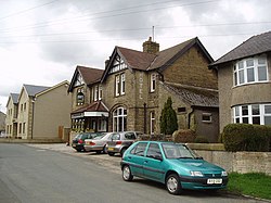
 The Black Bull Hotel. | |
| Location | |
| Grid reference: | SD806458 |
| Location: | 53°54’29"N, 2°17’42"W |
| Data | |
| Population: | 382 (2001) |
| Post town: | Clitheroe |
| Postcode: | BB7 |
| Dialling code: | 01200 |
| Local Government | |
| Council: | Ribble Valley |
| Parliamentary constituency: |
Ribble Valley |
Rimington is a rural village and parish in the West Riding of Yorkshire. It originates as a township of the ancient parish of Gisburn, in the Staincliffe Wapentake, becoming a civil parish in 1866. The population of the civil parish was 382 at the 2001 Census, however at the 2011 Census Middop was included with Rimington giving a total of 480.[1] It is east of Clitheroe and south of the A59 road. The village consists of the hamlets of Howgill, Martin Top, Newby, and Stopper Lane.
History
The village was listed in the Domesday Book as "Renistone". The name Boulton (Bolton) is listed in land deeds of 1302,[2] and Robert Elwald son of Alan listed 1304.[3]
Since Tudor times, until the late 19th century, lead mining was an important industry around the village. At one time silver was derived as a by-product of the mining, to the extent that Queen Elizabeth I declared the Stopper Lane Mine as being a Mine Royal.[4]
Francis Duckworth (1862–1941) was born in the village, and composed several hymn tunes including one named after the village.[5] There is a plaque to his memory was placed above the doorway to the former Methodist Chapel in Stopper Lane. Salem Chapel, the local Congregational Church at Martin Top, was founded in 1816 and continues to serve the area.[6][7]
Rimington railway station opened in 1872 and closed in 1959, and was on the Ribble Valley Line.
Rimington Memorial Institute was built in 1927 to commemorate the First World War and still serves as the venue for parish council, the Women's Institute and garden club meetings, indoor bowls, table tennis, whist and domino drives, as well as village dances and other events. It has recently been refurbished and upgraded.[8]
References
- ↑ UK Census (2011). "Local Area Report – Rimington Parish (1170215127)". Nomis. Office for National Statistics. https://www.nomisweb.co.uk/sources/census_2011_ks/report?compare=1170215127. Retrieved 11 February 2018
- ↑ Yorkshire Deeds,Vol 8, By Charles Travis Clay
- ↑ Calendar of Close Rolls, Vol 1302-7
- ↑ Freethy, Ron (2007-07-24). "Tourist guide to Rimington". Newsquest Media Group. http://www.lancashiretelegraph.co.uk/leisure/touristguide/index/1203560.Tourist_guide_to_Rimington/. Retrieved 2008-08-10.
- ↑ Kelsall, Dennis and Jan (2005). The Ribble Way: A Northern England Trail. Milnthorpe: Cicerone Press. p. 86. ISBN 978-1-85284-456-1. OCLC 64081876. https://books.google.com/books?id=9iQExYau08UC&pg=PA86&lpg=PA86&source=web&ots=Ly0vkvGzrs&sig=fLhu1hxCO8Axz17Fp7z--QSO7nw#PPA86,M1.
- ↑ "Salem Chapel, Martin Top". Martintop.org.uk. 20 March 2016. http://www.martintop.org.uk/. Retrieved 26 March 2016.
- ↑ "Salem Chapel, Rimington". Findachurch.co.uk. http://www.findachurch.co.uk/details/rimington/51308.htm. Retrieved 26 March 2016.
- ↑ "Rimington and Middop village". Gisburn.org.uk. http://www.gisburn.org.uk/rimington/. Retrieved 26 March 2016.
Outside links
| ("Wikimedia Commons" has material about Rimington) |