Muckle Flugga: Difference between revisions
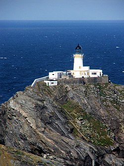
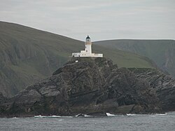
Created page with 'thumb|250px|The Muckle Flugga lighthouse thumb|250px|Island Muckle Flugga '''Muckle Flugga''' is a small…' |
m →Outside links: Bottom box |
||
| Line 29: | Line 29: | ||
[[Category:Shetland]] | [[Category:Shetland]] | ||
{{Shetland}} | |||
Revision as of 12:19, 14 June 2011


Muckle Flugga is a small rocky island north of Unst among the Shetland Islands. Of all the islands of the British Isles, Muckle Flugga is the northernmost apart from the little islet of Out Stack some yards beyond it. Muckle Flugga used to be the northernmost inhabited island of Britain, but lost that title when the lighthouse was automated and the last residents moved off the isle.
The name comes from Old Norse, Mikla Flugey, meaning "large steep-sided island". The original name was "North Unst", but in 1964 that was changed to "Muckle Flugga".[1]
According to local folklore, Muckle Flugga and nearby Out Stack were formed when two giants, Herma and Saxa, fell in love with the same mermaid. They fought over her by throwing large rocks at each other, one of which became Muckle Flugga. To get rid of them, the mermaid offered to marry whichever one would follow her to the North Pole. They both followed her and drowned, as neither could swim.
Lighthouse
Muckle Flugga is home to the Muckle Flugga Lighthouse, built by Thomas and David Stevenson in 1854, originally to protect ships during the Crimean War. First lit on 1 January 1858, it stands 64 feet high, has 103 steps to the top, and is Britain's most northerly lighthouse. The light beam flashes white every 20 seconds, with a nominal range of 22 miles. In March 1995 it was fully automated.
The lighthouse is operated by the Commissioners for the Northern Lighthouses.
The first tower
In 1851 it was decided to build a lighthouse on north Unst but, because of difficulties in determining the exact location, nothing had been done by the start of 1854. During the Crimean War, the government urged the commissioners to set up a light on Muckle Flugga to protect Her Majesty's ships. A temporary lighthouse 50 feet high was built 200 feet above sea level and lit on 11 October 1854. It was thought to be high and safe enough to withstand the elements, but when winter storms began waves broke heavily on the tower and burst the door to the living quarters open. The principal keeper reported that 40 feet of stone dyke had been broken down, and the keepers had no dry place to sit or sleep. Plans were made for a higher and more permanent lighthouse, but there were still disagreements about where to locate it, on Muckle Flugga or on Lamba Ness. The orders to start the work on the new Muckle Flugga tower were finally given in June 1855.
Muckle Flugga Shore Station
Muckle Flugga was one of the few Northern Lighthouses which had a separate shore station, on Hermaness, that served as accommodation for the lighthouse keepers, when they were off duty. The shore station was sold off when the lighthouse was automated. It now hosts the Hermaness Visitor Centre at the entrance to the neighbouring Hermaness Nature Reserve, managed by Scottish Natural Heritage.
References
Outside links
- Muckle Flugga Lighthouse
- Shetlopedia.com - Muckle Flugga
- History of Muckle Flugga Lighthouse - Northern Lighthouse Board
- Lighthouse Explorer
| Islands of Shetland |
|---|
|
Inhabited islands: |