Tortola: Difference between revisions
Created page with '{{Infobox island |name=Tortola |county=British Virgin Islands |picture=Tortola.jpg |map=BritishVirginIsland map.png |latitude=18° 25' N |longitude=64° 35' W |area=21½ square m…' |
mNo edit summary |
||
| Line 4: | Line 4: | ||
|picture=Tortola.jpg | |picture=Tortola.jpg | ||
|map=BritishVirginIsland map.png | |map=BritishVirginIsland map.png | ||
|latitude= | |latitude=18.4167 | ||
|longitude= | |longitude=-64.5833 | ||
|area=21½ square miles | |area=21½ square miles | ||
|highest point=[[Mount Sage]], 1,750 feet | |highest point=[[Mount Sage]], 1,750 feet | ||
Revision as of 14:51, 1 August 2014
| Tortola | |

| |
|---|---|
| Location | |
| Location: | 18°25’0"N, 64°34’60"W |
| Area: | 21½ square miles |
| Highest point: | Mount Sage, 1,750 feet |
| Data | |
| Population: | 23,908 |
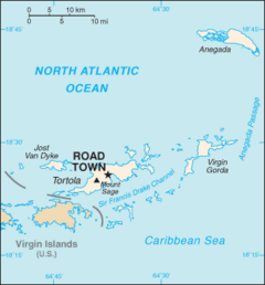
Tortola is the largest and most populous of the British Virgin Islands, and the location of the territory's capital and chief financial centre, Road Town.
Local tradition recounts that Christopher Columbus named the island Tortola, meaning "[land of the] Turtle Dove". Columbus in fact named the island Santa Ana. The later Dutch settled and called it Ter Tholen, after a coastal island forming part of the west coast of the Netherlands. When the British took over, they altered the name to its present-day Tortola.
History
In 1493 Christopher Columbus spotted the Virgin Islands and named them after the 11,000 virgins of the 4th-century martyr St Ursula. The Spaniards made a few attempts to settle the area, but pirates such as Blackbeard and Captain Kidd were the first permanent inhabitants of the island.
In the 17th century, the English, who had successfully usurped control of the area from the Dutch, established a permanent plantation colony on Tortola and the surrounding islands. The sugar cane industry, dependent on slave labour, dominated Tortola history over the next 150 years. It diminished in the mid-19th century after the abolition of slavery. A large proportion of the white landowning population left the British Virgin Islands during the economic downturn, but the political relationship between the island and the British continued and has been maintained.
Geography
Tortola is a mountainous island 13.5 miles long and 3 miles wide, with an area of 21½ square miles. Formed by volcanic activity, its highest peak is Mount Sage at 1750 feet. Tortola lies near an earthquake fault, and minor earthquakes are common.
Economy and demographics
The population of Tortola is 23,908. The principal town is Road Town, the capital of the British Virgin Islands.
Financial services are the main source of income to the island. The popular International Business Companies Act, passed in the early 1980s, led to significant growth in government revenue. BVI residents are amongst the most affluent in the Eastern Caribbean. Numerous residents from other Caribbean islands work there.
Although the British Virgin Islands are British, the territory uses the US dollar as its official currency. Tortola is home to many offshore companies that do business worldwide.
Attractions
The Northern coast has the best beaches on the island, including Smuggler's Cove, Long Bay, Cane Garden Bay, Brewer's Bay, Josiah's Bay and Lambert beach. In addition, to beaches there is Sailing, Surfing, Scuba Diving, Kite Boarding, Wind Surfing, Historic Site, Hiking and much more.
Transport
- Air: Flights to Terrance B Lettsome International Airport on Beef Island, just to the East of Tortola, connected by the Queen Elizabeth II Bridge.
- Ferries from Road Town or the West End of Tortola sail to the US Virgin Islands
Pictures
-
Road Town
-
Cane Garden Bay
-
Lambert Beach
-
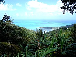
View of the North Coast

Outside links
| ("Wikimedia Commons" has material about Tortola) |
| The British Virgin Islands |
|---|
|
Anegada • Beef • Bellamy Cay • Buck • Carvel Rock • Cockroach • Cooper • Dead Chest • Diamond Cay • Dog Islands • East Seal Dog • Eustatia • Fallen Jerusalem • Frenchman's Cay • George Dog • Ginger • Great Camanoe • Great Dog • Great Thatch • Great Tobago • Green Cay • Guana • The Indians • Jost Van Dyke • Little Camanoe • Little Jost Van Dyke • Little Thatch • Little Tobago • Marina Cay • Mosquito • Nanny Cay • Necker • Norman • Old Jerusalem • Pelican • Peter • Prickly Pear • Round Rock • Saba Rock • Salt • Sandy Cay • Sandy Spit • Scrub • Tortola • Virgin Gorda • West Dog |


