The Saddle: Difference between revisions
Created page with '{{Infobox hill |name=The Saddle |county 1=Ross-shire |county 2=Inverness-shire |range=Glen Shiel Hills |SMC=10 |picture=Forcan Ridge The Saddle Glen Sheil - geograph.org.uk - 265…' |
No edit summary |
||
| Line 24: | Line 24: | ||
From here the route continues westwards up and over Sgurr nan Forcan and so up to the main summit. This section is often regarded one of the best ridge walks in Scotland. There is no technical rock-climbing on the ridge, but a good head for heights, appropriate footwear, and some scrambling ability are required. (In winter a rope may be needed to safeguard the descent from the ridge.) | From here the route continues westwards up and over Sgurr nan Forcan and so up to the main summit. This section is often regarded one of the best ridge walks in Scotland. There is no technical rock-climbing on the ridge, but a good head for heights, appropriate footwear, and some scrambling ability are required. (In winter a rope may be needed to safeguard the descent from the ridge.) | ||
The Saddle has two summits: the westerly one has a trig point, but it is not obvious which one is the true summit. [[Munro]] baggers prefer climb both. To descend back to the starting point, one can either retrace the ascent route, or drop south and then south east to reach the Bealach Coire Mhalagain, at {{map|NG944125}}. From here one can continue to [[Sgurr na Sgine]] or follow the line of an old dry-stone dyke | The Saddle has two summits: the westerly one has a trig point, but it is not obvious which one is the true summit. [[Munro]] baggers prefer climb both. To descend back to the starting point, one can either retrace the ascent route, or drop south and then south-east to reach the Bealach Coire Mhalagain, at {{map|NG944125}}. From here one can continue to [[Sgurr na Sgine]] or follow the line of an old dry-stone dyke north-east to get back to the top of the stalker's path to Glen Shiel. | ||
The walker not wishing to combine the ascent of The Saddle with Sgurr na Sgine will find that a rewarding day can be had by continuing westwards over the smaller tops of The Saddle and descending to [[Shiel Bridge]] about | The walker not wishing to combine the ascent of The Saddle with Sgurr na Sgine will find that a rewarding day can be had by continuing westwards over the smaller tops of The Saddle and descending to [[Shiel Bridge]] about three miles north-west of the starting point above. | ||
==Pictures== | ==Pictures== | ||
Revision as of 14:04, 13 October 2016
| The Saddle | |||
| Ross-shire, Inverness-shire | |||
|---|---|---|---|
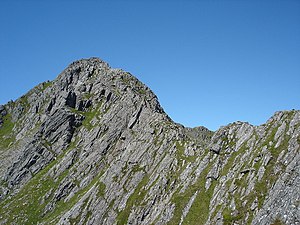
 The Forcan ridge on The Saddle | |||
| Range: | Glen Shiel Hills | ||
| Summit: | 3,314 feet NG936131 | ||
The Saddle is a famous mountain of the Highlands. It stands amongst the Glen Shiel Hills, the district packed with high peaks where Ross-shire and Inverness-shire meet near the west coast. The Saddle itself is on the border of the two shires. The Saddle reaches a height of 3,314 feet at its summit, and so it qualifies as a Munro.
Seen from the site of the Battle of Glen Shiel it forms (with Faochag) one of the best-known views in the Highlands.
The mountain's name refers to the shape of the summit ridge when seen from Glen Shiel with the twin summits and ridge in between resembling a saddle. The Saddle is known in Gaelic as An Dìollaid, its original name, though that name is fading from memory.[1]
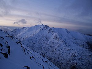
The mountain provides exciting and challenging climbing. The traverse of the Forcan Ridge — in winter or summer — is one of the classic Scottish mountain expeditions.
Ascent
The usual approach is to park beside the A87 just before the old quarry near Shiel Bridge. A stalker's path leads up westwards to a ridge at about 1,640 feet, just below the outlying top of Biod an Fhithich. From here the route turns south and climbs steeper ground to the foot of the Forcan Ridge.
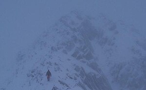
From here the route continues westwards up and over Sgurr nan Forcan and so up to the main summit. This section is often regarded one of the best ridge walks in Scotland. There is no technical rock-climbing on the ridge, but a good head for heights, appropriate footwear, and some scrambling ability are required. (In winter a rope may be needed to safeguard the descent from the ridge.)
The Saddle has two summits: the westerly one has a trig point, but it is not obvious which one is the true summit. Munro baggers prefer climb both. To descend back to the starting point, one can either retrace the ascent route, or drop south and then south-east to reach the Bealach Coire Mhalagain, at NG944125. From here one can continue to Sgurr na Sgine or follow the line of an old dry-stone dyke north-east to get back to the top of the stalker's path to Glen Shiel.
The walker not wishing to combine the ascent of The Saddle with Sgurr na Sgine will find that a rewarding day can be had by continuing westwards over the smaller tops of The Saddle and descending to Shiel Bridge about three miles north-west of the starting point above.
Pictures
 |
 |
References
| Munros in SMC Area SMC Section 10 - Loch Eil to Glen Shiel |
|---|
|
Aonach air Chrith • Beinn Sgritheall • Creag a' Mhaim • Creag nan Damh • Druim Shionnach • Gairich • Garbh Chioch Mhor • Gleouraich • Gulvain • Ladhar Bheinn • Luinne Bheinn • Maol Chinn-dearg • Meall Buidhe • Meall na Teanga • Sgùrr a' Mhaoraich • Sgùrr an Doire Leathain • Sgùrr an Lochain • Sgùrr Mòr • Sgùrr na Cìche • Sgùrr na Sgine • Sgurr nan Coireachan (Glen Dessary) • Sgurr nan Coireachan (Glenfinnan) • Sgùrr Thuilm • Spidean Mialach • Sron a' Choire Ghairbh • The Saddle |