Paythorne: Difference between revisions
No edit summary |
No edit summary |
||
| Line 15: | Line 15: | ||
|LG district=Ribble Valley | |LG district=Ribble Valley | ||
}} | }} | ||
'''Paythorne''' is a small village in the [[West Riding of Yorkshire]], within [[Ribblesdale]]. The [[River Ribble]] runs through the village. | '''Paythorne''' is a small village in the [[West Riding of Yorkshire|West Riding]] of [[Yorkshire]], within [[Ribblesdale]]. The [[River Ribble]] runs through the village. Paythorne originates as a township of the ancient parish of [[Gisburn]], becoming a civil parish in 1866.<ref>{{cite web | url=http://www.visionofbritain.org.uk/gaztext_page.jsp?u_id=10459217&c_id=10001043 | title=Paythorne Tn/CP Yorkshire through time – Descriptive Gazetteer entries | work=A Vision of Britain through Time | publisher=University of Portsmouth & others | year=2008 | accessdate=2008-12-14 }}</ref> | ||
Paythorne lies north-east of [[Clitheroe]]. Other parishes adjacent to Paythorne are [[Halton West]], [[Nappa]], [[Newsholme]], [[Horton in Ribblesdale]], [[Gisburn]], [[Sawley, Ribble Valley|Sawley]], [[Bolton-by-Bowland]] and [[Gisburn Forest]]. | Paythorne lies north-east of [[Clitheroe]]. Other civil parishes adjacent to Paythorne are [[Halton West]], [[Nappa]], [[Newsholme, West Riding|Newsholme]], [[Horton in Ribblesdale]], [[Gisburn]], [[Sawley, Ribble Valley|Sawley]], [[Bolton-by-Bowland]] and [[Gisburn Forest]]. | ||
The nearest town is [[Barnoldswick]], four miles south-east of the village. | The nearest town is [[Barnoldswick]], four miles south-east of the village. | ||
Paythorne is on the edge of the [[Forest of Bowland]] ''Area of Outstanding Natural Beauty'', and a small area in the west of the parish is within the area's boundary. The [[Ribble Way]] long distance walk passes through the village.<ref>{{cite book | title=Walking the Ribble Way – A guide from sea to source | authors=Alan Shepley and Graham Wilkinson | publisher=Wood Education Programme Trust | year=2005 | isbn=978-0-9541809-1-1 | oclc=124023932 }}</ref> | Paythorne is on the edge of the [[Forest of Bowland]] ''Area of Outstanding Natural Beauty'', and a small area in the west of the parish is within the area's boundary. The [[Ribble Way]] long-distance walk passes through the village.<ref>{{cite book | title=Walking the Ribble Way – A guide from sea to source | authors=Alan Shepley and Graham Wilkinson | publisher=Wood Education Programme Trust | year=2005 | isbn=978-0-9541809-1-1 | oclc=124023932 }}</ref> | ||
Paythorne is a small village, with not many facilities although it has a pub (the Buck Inn) and a Methodist chapel. The nearest Post Office is at [[Gisburn]]. The area surrounding the village consists of several farms, and moorland including Paythorne Moor north of the village. | Paythorne is a small village, with not many facilities although it has a pub (the Buck Inn) and a Methodist chapel. The nearest Post Office is at [[Gisburn]]. The area surrounding the village consists of several farms, and moorland including Paythorne Moor north of the village. | ||
The village is mentioned in the [[Domesday Book]] of 1086. The meaning of the place name is uncertain, however suggestions have included "a thorn bush beside a pathway" and "a peacock shaped thorn bush". | The village is mentioned in the [[Domesday Book]] of 1086. The meaning of the place name is uncertain, however suggestions have included "a thorn bush beside a pathway" and "a peacock shaped thorn bush". | ||
In the 2001 census, Paythorne had a population of 95, in 35 households. | In the 2001 census, Paythorne had a population of 95, in 35 households. | ||
Latest revision as of 11:22, 27 February 2020
| Paythorne | |
| Yorkshire West Riding | |
|---|---|
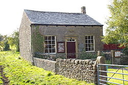
 Paythorne Methodist Chapel | |
| Location | |
| Grid reference: | SD829519 |
| Location: | 53°57’47"N, 2°15’40"W |
| Data | |
| Population: | 95 (2001) |
| Post town: | Barnoldswick |
| Postcode: | BB7 |
| Local Government | |
| Council: | Ribble Valley |
Paythorne is a small village in the West Riding of Yorkshire, within Ribblesdale. The River Ribble runs through the village. Paythorne originates as a township of the ancient parish of Gisburn, becoming a civil parish in 1866.[1]
Paythorne lies north-east of Clitheroe. Other civil parishes adjacent to Paythorne are Halton West, Nappa, Newsholme, Horton in Ribblesdale, Gisburn, Sawley, Bolton-by-Bowland and Gisburn Forest.
The nearest town is Barnoldswick, four miles south-east of the village.
Paythorne is on the edge of the Forest of Bowland Area of Outstanding Natural Beauty, and a small area in the west of the parish is within the area's boundary. The Ribble Way long-distance walk passes through the village.[2]
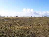
Paythorne is a small village, with not many facilities although it has a pub (the Buck Inn) and a Methodist chapel. The nearest Post Office is at Gisburn. The area surrounding the village consists of several farms, and moorland including Paythorne Moor north of the village.
The village is mentioned in the Domesday Book of 1086. The meaning of the place name is uncertain, however suggestions have included "a thorn bush beside a pathway" and "a peacock shaped thorn bush".
In the 2001 census, Paythorne had a population of 95, in 35 households.

| ("Wikimedia Commons" has material about Paythorne) |
References
- ↑ "Paythorne Tn/CP Yorkshire through time – Descriptive Gazetteer entries". A Vision of Britain through Time. University of Portsmouth & others. 2008. http://www.visionofbritain.org.uk/gaztext_page.jsp?u_id=10459217&c_id=10001043. Retrieved 2008-12-14.
- ↑ Alan Shepley and Graham Wilkinson (2005). Walking the Ribble Way – A guide from sea to source. Wood Education Programme Trust. ISBN 978-0-9541809-1-1. OCLC 124023932.
