Great Whernside: Difference between revisions
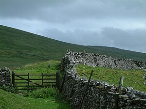
Created page with '{{Infobox hill |name=Great Whernside |county=Yorkshire |picture=Great_Whernside.jpg |picture caption=Great Whernside from by Tor Dyke |height=2,310 feet |range=Pennines |os ref=S…' |
No edit summary |
||
| Line 6: | Line 6: | ||
|height=2,310 feet | |height=2,310 feet | ||
|range=Pennines | |range=Pennines | ||
|os ref=SE002739 | |os grid ref=SE002739 | ||
|latitude=54.160908 | |||
|longitude=-1.998434 | |||
}} | }} | ||
'''Great Whernside''' is a high fell in the [[West Riding of Yorkshire]] and at the heads of the [[Yorkshire Dales]]. It should not to be confused with the better known [[Whernside]], some 17 miles to the west. | '''Great Whernside''' is a high fell in the [[West Riding of Yorkshire]] and at the heads of the [[Yorkshire Dales]]. It should not to be confused with the better known [[Whernside]], some 17 miles to the west. | ||
| Line 12: | Line 14: | ||
Great Whernside stands at the head of both [[Wharfedale]] and [[Nidderdale]], forming the watershed between them. It is also on the boundary between the Yorkshire Dales National Park and the Nidderdale Area of Outstanding Natural Beauty. The summit of Great Whernside is the highest point of the eastern flank of [[Wharfedale]] above [[Kettlewell]]. | Great Whernside stands at the head of both [[Wharfedale]] and [[Nidderdale]], forming the watershed between them. It is also on the boundary between the Yorkshire Dales National Park and the Nidderdale Area of Outstanding Natural Beauty. The summit of Great Whernside is the highest point of the eastern flank of [[Wharfedale]] above [[Kettlewell]]. | ||
The curving escarpment above the pass between Wharfedale and [[Coverdale]] is known as "Whernside", of which Great Whernside is the highest point; [[Little Whernside]] is a few miles to the | The curving escarpment above the pass between Wharfedale and [[Coverdale]] is known as "Whernside", of which Great Whernside is the highest point; [[Little Whernside]] is a few miles to the north-east. Little Whernside nearby forms the watershed between Coverdale and Nidderdale. | ||
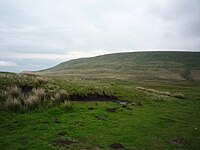
[[File:Paths towards Great Whernside - geograph.org.uk - 1344055.jpg|left|thumb|200px|Approaching Great Whernside]] | [[File:Paths towards Great Whernside - geograph.org.uk - 1344055.jpg|left|thumb|200px|Approaching Great Whernside]] | ||
Latest revision as of 14:38, 24 April 2018
| Great Whernside | |||
| Yorkshire | |||
|---|---|---|---|
 Great Whernside from by Tor Dyke | |||
| Range: | Pennines | ||
| Summit: | 2,310 feet SE002739 54°9’39"N, 1°59’54"W | ||
Great Whernside is a high fell in the West Riding of Yorkshire and at the heads of the Yorkshire Dales. It should not to be confused with the better known Whernside, some 17 miles to the west.
Great Whernside stands at the head of both Wharfedale and Nidderdale, forming the watershed between them. It is also on the boundary between the Yorkshire Dales National Park and the Nidderdale Area of Outstanding Natural Beauty. The summit of Great Whernside is the highest point of the eastern flank of Wharfedale above Kettlewell.
The curving escarpment above the pass between Wharfedale and Coverdale is known as "Whernside", of which Great Whernside is the highest point; Little Whernside is a few miles to the north-east. Little Whernside nearby forms the watershed between Coverdale and Nidderdale.

The River Nidd rises on the eastern slopes of Great Whernside, above Angram Reservoir.