Beinn a' Chreachain: Difference between revisions
mNo edit summary |
No edit summary |
||
| (3 intermediate revisions by 2 users not shown) | |||
| Line 3: | Line 3: | ||
|county 1=Argyll | |county 1=Argyll | ||
|county 2=Perthshire | |county 2=Perthshire | ||
|SMC=2 | |||
|picture=Beinn a' Chreachain, from the north east ridge - geograph.org.uk - 648911.jpg | |picture=Beinn a' Chreachain, from the north east ridge - geograph.org.uk - 648911.jpg | ||
|picture caption= | |picture caption= | ||
| Line 8: | Line 9: | ||
|range=Bridge of Orchy Hills | |range=Bridge of Orchy Hills | ||
|os grid ref=NN37394404 | |os grid ref=NN37394404 | ||
|latitude=56.560084 | |||
|longitude=-4.647557 | |||
}} | }} | ||
'''Beinn a' Chreachain''' is a mountain whose summit marks the border of [[Argyllshire]] with [[Perthshire]], and the watershed between the west and east coasts. It has a distinctive conical top, and rises to the north-west of [[Loch Lyon]]. Its summit is 3,547 feet above sea level and so it is classified as a [[Munro]]. | '''Beinn a' Chreachain''' is a mountain whose summit marks the border of [[Argyllshire]] with [[Perthshire]], and the watershed between the west and east coasts. It has a distinctive conical top, and rises to the north-west of [[Loch Lyon]]. Its summit is 3,547 feet above sea level and so it is classified as a [[Munro]]. | ||
| Line 15: | Line 18: | ||
* The Munros, Scottish Mountaineering Trust, 1986, Donald Bennett (Editor) ISBN 0-907521-13-4 | * The Munros, Scottish Mountaineering Trust, 1986, Donald Bennett (Editor) ISBN 0-907521-13-4 | ||
{{DEFAULTSORT:Beinn A | {{DEFAULTSORT:Beinn A Chreachain}} | ||
{{Munro}} | |||
Latest revision as of 13:47, 5 July 2017
| Beinn a' Chreachain | |||
| Argyllshire, Perthshire | |||
|---|---|---|---|

| |||
| Range: | Bridge of Orchy Hills | ||
| Summit: | 3,547 feet NN37394404 56°33’36"N, 4°38’51"W | ||
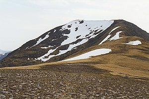
Beinn a' Chreachain is a mountain whose summit marks the border of Argyllshire with Perthshire, and the watershed between the west and east coasts. It has a distinctive conical top, and rises to the north-west of Loch Lyon. Its summit is 3,547 feet above sea level and so it is classified as a Munro.
References
- The Munros, Scottish Mountaineering Trust, 1986, Donald Bennett (Editor) ISBN 0-907521-13-4
| Munros in SMC Area SMC Section 2 - Loch Tay to Rannoch Moor |
|---|
|
Stuc a' Chroin • An Stùc • Beinn a' Chreachain • Beinn Achaladair • Beinn an Dothaidh • Beinn Dorain • Beinn Ghlas • Beinn Heasgarnich • Beinn Mhanach • Ben Challum • Ben Lawers • Carn Gorm • Carn Mairg • Creag Mhòr • Meall a' Choire Leith • Meall Buidhe, Perthshire • Meall Corranaich • Meall Garbh (Càrn Mairg) • Meall Garbh (Lawers) • Meall Ghaordie • Meall Glas • Meall Greigh • Meall na Aighean • Meall nan Tarmachan • Schiehallion • Sgiath Chuil • Stuchd an Lochain |