Islandmagee: Difference between revisions
mNo edit summary |
No edit summary |
||
| (One intermediate revision by one other user not shown) | |||
| Line 1: | Line 1: | ||
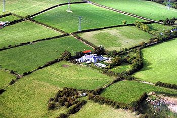
[[File:Farmhouse Islandmagee - geograph.org.uk - 345936.jpg|right|thumb|350px|Farmland on Islandmagee]] | [[File:Farmhouse Islandmagee - geograph.org.uk - 345936.jpg|right|thumb|350px|Farmland on Islandmagee]] | ||
'''Islandmagee''' is a peninsula on the east coast of [[County Antrim]], on the [[North Channel]]. The peninsula has its root a little north of [[Carrickfergus]], and stretches northward along the coast for | {{county|Antrim}} | ||
'''Islandmagee''' is a peninsula on the east coast of [[County Antrim]], on the [[North Channel]]. The peninsula has its root a little north of [[Carrickfergus]], and stretches northward along the coast for seven miles as far as [[Larne]], creating between itself and the mainland of Antrim a sea lough known as [[Larne Lough]]. The sheltered water of this lough forms Larne's capacious natural harbour. | |||
The peninsula is a sparsely populated rural community with a long history since the Middle Stone Age. Parts of the Islandmagee are owned by the [[National Trust for Places of Historic Interest or Natural Beauty|National Trust]]. | The peninsula is a sparsely populated rural community with a long history since the Middle Stone Age. Parts of the Islandmagee are owned by the [[National Trust for Places of Historic Interest or Natural Beauty|National Trust]]. | ||
| Line 80: | Line 81: | ||
==Outside links== | ==Outside links== | ||
{{commons}} | {{commons}} | ||
*Location map: {{wmap|54.79643|-5.70304|zoom=13}} | |||
*[http://www.islandmageecommunity.org/ Islandmagee Community website] | *[http://www.islandmageecommunity.org/ Islandmagee Community website] | ||
*{{NT link | *{{NT link}} - National Trust | ||
==References== | ==References== | ||
{{Reflist}} | {{Reflist}} | ||
[[Category:National Trust properties in County Antrim]] | [[Category:National Trust properties in County Antrim]] | ||
[[Category:County Antrim]] | [[Category:County Antrim]] | ||
Latest revision as of 11:02, 5 February 2019

Islandmagee is a peninsula on the east coast of County Antrim, on the North Channel. The peninsula has its root a little north of Carrickfergus, and stretches northward along the coast for seven miles as far as Larne, creating between itself and the mainland of Antrim a sea lough known as Larne Lough. The sheltered water of this lough forms Larne's capacious natural harbour.
The peninsula is a sparsely populated rural community with a long history since the Middle Stone Age. Parts of the Islandmagee are owned by the National Trust.
The name 'Islandmagee' is said to come form the Gaelic Oileán MhicAodha, meaning 'MacAodha's island', after a clan believed to have dwelt here, whether of Scottish or Irish provenance. It was anciently known according to some scholars as Rinn Seimhne or Inis Seimhne.
As part of an agricultural crop rotation programme of old beans were grown to supply nitrogen to the soil. "Bean Eaters" became a nickname for the people of Islandmagee.
On Islandmagee stands Ulster's main power station, Ballylumford.
History
The Bissett family held the tenancy of the peninsula in Elizabeth I's reign, their rent being an annual offering of goshawks, birds which bred on the rugged white chalk cliffs nearby.
Archaeology
The Ballylumford Dolmen, known locally as the "Druid's Altar", a megalithic monument which could be 4000 years old, or be the remains of an earlier Neolithic simple passage tomb. It consists of four upright stones, with a heavy capstone and a fallenstone within the structure.
- Neolithic houses excavated at Ballyharry. Finds included Neolithic pottery, flint arrowheads, javelin heads, polished stone axe fragments and quernstones.

Villages and townlands
The peninsula is part of the parish of Islandmagee. The boundaries of the parish and the peninsula match. Like the rest of Ireland, this parish is split into a number of townlands, whose names are derived from the ancient Irish language. There are 25 townlands on Islandmagee but just two small villages.
There are two villages on Islandmagee:
The townlands of the peninsula are:
|
|
|
|
Nature and geography
Here by the sea are Kittiwakes, Guillemots and Razorbills flocking around the pig-shaped Isle of Muck nearby.
Brown's Bay to the northwest has a fine, sandy beach and walks from up to Skernaghan Point will blow the cobwebs away, and from the point are spectacular views of the Antrim coast, stretching away at the foot of the Nine Glens.
The Gobbins
To the south part of Islandmagee are found the cliffs known as 'The Gobbins', now an ASSI, and from here stunning broad views look out along the peninsula and beyond.

The Gobbins Cliff Path was cut into the rock of the cliffs; a walkway of carved way, suspended walkways and bridges; a feat of engineering once so popular more visitrs came here than to Antrim's more famous coastal attraction, the Giant's Causeway. Restoration is now in progress with a view to opening the path to the public once again.
Sport
- Football: Islandmagee FC
- Golf:
- Whitehead Golf Club (18 holes)
- Larne Golf Club (9 holes)
- Horse riding: Rocklyn Stables and Islandmagee Riding Centre.
- Fishing: the most common sport hereabouts
Outside links
| ("Wikimedia Commons" has material about Islandmagee) |
- Location map: 54°47’47"N, 5°42’11"W
- Islandmagee Community website
- Islandmagee - National Trust
