River Rawthey: Difference between revisions
Created page with 'The '''River Rawthey''' is a river in West Riding of Yorkshire, which enters Westmorland briefly below Sedbergh before becoming a tributary of the River Lune. Th…' |
No edit summary |
||
| (2 intermediate revisions by 2 users not shown) | |||
| Line 1: | Line 1: | ||
The '''River Rawthey''' is a river in [[West Riding of Yorkshire]] | {{county|York}} | ||
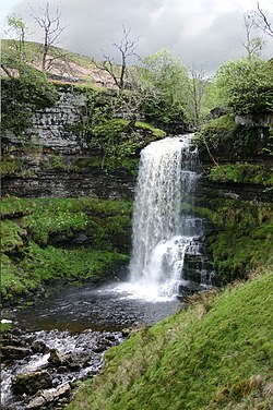
[[File:Uldale Force, River Rawthey, Cumbria - geograph.org.uk - 441191.jpg|thumb|250px|Uldale Force on the Rawthey]] | |||
The '''River Rawthey''' is a river in the [[West Riding of Yorkshire|West Riding]] of [[Yorkshire]], which forms the part of the border between that county and [[Westmorland]], before becoming confluent with the [[River Lune]]. | |||
The Rawthey rises on [[Baugh Fell]], formed by two main brooks off that mountain, the Rawthey Gill and the Haskhaw Gill, which join at Rawthey Foot. Rawthey Gill begins in name at Gill Head, at the union of streams on East Baugh Fell trickling down from the East Tarns on the summit plateau of the fell , where the Haskhaw Gill begins too. | The Rawthey rises on [[Baugh Fell]], formed by two main brooks off that mountain, the Rawthey Gill and the Haskhaw Gill, which join at Rawthey Foot. Rawthey Gill begins in name at Gill Head, at the union of streams on East Baugh Fell trickling down from the East Tarns on the summit plateau of the fell, where the Haskhaw Gill begins too. | ||
From Baugh Fell, the Rawthey flows northwards and picks up the waters of the Whin Stone Gill in Uldale before skirting round Bluecaster (a subsidiary summit of Baugh Fell), after which the river moves south-by- | From Baugh Fell, the Rawthey flows northwards and picks up the waters of the Whin Stone Gill in Uldale before skirting round Bluecaster (a subsidiary summit of Baugh Fell), after which the river moves south-by-south-west through Cautley. | ||
The Rawthey is joined by the [[Clough River]], coming from Garsdale, near Dowbiggin, and, having run past [[Castleshaw Tower]], the [[River Dee, Yorkshire|River Dee]] close to [[Sedbergh]]. | The Rawthey is joined by the [[Clough River]], coming from Garsdale, near Dowbiggin, and, having run past [[Castleshaw Tower]], the [[River Dee, Yorkshire|River Dee]] close to [[Sedbergh]]. | ||
A little below Sedbergh, the Rawthey joins the [[River Lune|Lune]], at Stangerthwaite. | A little below Sedbergh, the Rawthey joins the [[River Lune|Lune]], at Stangerthwaite. | ||
==Outside links== | |||
*Location of the source: {{wmap|54.3454|-2.39138|zoom=14}} | |||
*Location of the mouth: {{wmap|54.30043|-2.5722|zoom=14}} | |||
{{DEFAULTSORT:Rawthey River}} | {{DEFAULTSORT:Rawthey River}} | ||
[[Category:Rivers of Yorkshire|Rawthey]] | [[Category:Rivers of Yorkshire|Rawthey]] | ||
[[Category:Rivers of Westmorland|Rawthey]] | |||
Latest revision as of 18:15, 21 January 2019

The River Rawthey is a river in the West Riding of Yorkshire, which forms the part of the border between that county and Westmorland, before becoming confluent with the River Lune.
The Rawthey rises on Baugh Fell, formed by two main brooks off that mountain, the Rawthey Gill and the Haskhaw Gill, which join at Rawthey Foot. Rawthey Gill begins in name at Gill Head, at the union of streams on East Baugh Fell trickling down from the East Tarns on the summit plateau of the fell, where the Haskhaw Gill begins too.
From Baugh Fell, the Rawthey flows northwards and picks up the waters of the Whin Stone Gill in Uldale before skirting round Bluecaster (a subsidiary summit of Baugh Fell), after which the river moves south-by-south-west through Cautley.
The Rawthey is joined by the Clough River, coming from Garsdale, near Dowbiggin, and, having run past Castleshaw Tower, the River Dee close to Sedbergh.
A little below Sedbergh, the Rawthey joins the Lune, at Stangerthwaite.
Outside links
- Location of the source: 54°20’43"N, 2°23’29"W
- Location of the mouth: 54°18’2"N, 2°34’20"W