Somerset Island: Difference between revisions
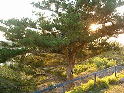
Created page with "{{Infobox island |name=Somersert Island |territory=Bermuda |picture=Bermuda Cedar at Scaur Hill Fort.jpg |picture caption=Bermuda cedar at Scaur Hill Fort on Somerset Island |..." |
No edit summary |
||
| Line 4: | Line 4: | ||
|picture=Bermuda Cedar at Scaur Hill Fort.jpg | |picture=Bermuda Cedar at Scaur Hill Fort.jpg | ||
|picture caption=Bermuda cedar at Scaur Hill Fort on Somerset Island | |picture caption=Bermuda cedar at Scaur Hill Fort on Somerset Island | ||
|map=Somerset Island | |map=Somerset Island - Bermuda.svg | ||
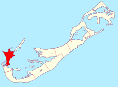
|map caption=Location of Somerset Island | |map caption=Location of Somerset Island | ||
|latitude=32.29639 | |latitude=32.29639 | ||
Latest revision as of 21:28, 6 March 2016
| Somersert Island | |
 Bermuda cedar at Scaur Hill Fort on Somerset Island | |
|---|---|
| Main village: | Somerset Village |
| Location | |
| Location: | 32.29639 -64.86944 |
| Area: | 702 acres |
| Data | |
Somerset Island is one of the main islands of Bermuda, lying in the far west of the territory, part of the main chain of islands, between the Main Island to the south and Boaz Island off the the north-east. It is joined to the Main Island by the remarkable Somerset Bridge; the shortest working drawbridge in the world. A further bridge links Boaz Island.
The island covers 702 acres and as such it comprises about half of the parish of Sandys. It is the largest of a chain of islands which extend along the northwestern coast of the Great Sound.
The main village, Somerset, stands in the northern part of the island.
The coast of Somerset Island includes several bays, notably Mangrove Bay in the northeast and the natural harbour, Ely's Harbour, in the southwest. Other features of the island include Daniel's Head, the island's westernmost point, and the historic Fort Scaur.
