Worsbrough
| Worsbrough | |
| Yorkshire West Riding | |
|---|---|
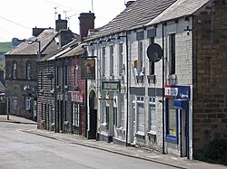
 High Street, Worsbrough | |
| Location | |
| Grid reference: | SE357043 |
| Location: | 53°32’5"N, 1°27’44"W |
| Data | |
| Population: | 9,516 |
| Post town: | Barnsley |
| Postcode: | S70 |
| Dialling code: | 01226 |
| Local Government | |
| Council: | Barnsley |
| Parliamentary constituency: |
Barnsley East |
Worsbrough is an area about two miles south of Barnsley in the West Riding of Yorkshire, in the Staincross Wapentake.
The name of Worsbrough includes Worsbrough Bridge, Worsbrough Common, Worsbrough Dale, Worsbrough Village and Ward Green.
The River Dove flows east–west through Worsbrough and the reservoir before joining the River Dearne and the area is built on its valley. The A61 traverses this large valley, south of Barnsley, before passing through Birdwell to junction 36 of the M1. A railway line, the former Woodhead Line, passed along the valley as well, which is now the Trans-Pennine Trail. It joined the Huddersfield-Barnsley Line at Silkstone Common to the west and across to Wombwell, a mile to the east, where it met the former Doncaster – Barnsley Line, which also is part of the Trans-Pennine Trail.
Churches

- Church of England:
- St Mary's, in Worsbrough Village
- St Thomas and St James, in Worsbrough Dale
- St Luke's in Worsbrough Common
- Independent / evangelical: Community Church
- Roman Catholic: Our Lady and St James, built 1902
St Thomas and St James' Church stands on Bank End Road in Worsbrough Dale. The church was built in 1858 and consecrated in 1859. The Wentworth family of Wentworth Castle gave a donation of £2,000 and other people provided donations of smaller amounts or helped in other ways. The total cost of the church building was about £3,000. The church is a Grade II listed building.[1]
St Mary's is a Grade I listed building.[2]
Community Church on the High Street was built in 1854 as an Ebenezer Wesleyan Reform church, as attested on its foundation stones. It was extended in 1903.[3]
History
Worsbrough is listed in the Domesday Book of 1086:[4]
In Wircesburg Gerneber and Haldene had five carucates of land and a half to be taxed where there may be four ploughs. Gamel and Chetelber now have it of Ilbert, themselves two ploughs, and four bordars, and one mill pays two shillings. Wood pasture half a mile long and half a mile broad. Value in King Edward's time four pounds, now thirty shillings.
The name 'Worsbrough' means 'Weorc's fortified place'.[5] The village name was written Worsborough before the 19th century and through the 20th century.[6]
Coal mining was central to the productivity of the area for centuries. Seventy five miners who were killed in the 1849 Darley Main Colliery disaster[7] lie buried in the parish churchyard.
The Great Central Railway's Worsborough (or Worsbrough) Branch was a goods only branch running from West Silkstone Junction on the Penistone to Barnsley line to Wombwell Main Junction on the South Yorkshire Railway. Numerous coal mines were served along the route, but principally it was a bypass route to relieve congestion at Barnsley and there were no intermediate stations. The line was an engineering nightmare. There were two tunnels—Silkstone No. 1, 289 yards and Silkstone No. 2, 74 yards—and the grades were quite horrendous. The 7-mile Worsborough Bank included a 3-mile section at an average grade of 1 in 40. With the mining subsidence that took place over the years the grade was in places even worse, making this the steepest incline on a main line in Great Britain.Template:Cn The line opened to traffic on 2 August 1880. It was electrified as part of the Manchester to Sheffield and Wath electrification of the 1950s, but closed with the rest of that system in the 1981.[8]
About the village
Around Worsbrough may be found Houndhill, Wigfield Farm, Worsbrough Mill and Worsbrough Reservoir, which are in Worsbrough Country Park. There is also a canal which was a branch off the Dearne and Dove Canal.
There are also several pubs in the Worsbrough area, most notably The Cutting Edge (demolished), The Red Lion Country Inn (previously The Olive Branch, The Button Mill Inn, and before that, The Red Lion), The Greyhound, The Boatman's Rest (known locally as the Pod), the Wharf (Now the Mogul Room Indian Restaurant), The Ship, The Darley, The Masons Arms (demolished), Ward Green WMC, the Dale Tavern and Swaithe Main WMC.
Sport and recreation
- Bowls:
- High Street Bowling Club in Worsbrough Dale
- Kendal Vale Bowling Club in Worsbrough Bridge
- Cricket:
- Worsbrough Bridge Cricket Club
- Worsbrough Bridge Cricket Club
- Football: Worsbrough Bridge Athletic F.C.
The Trans Pennine Trail runs through Worsbrough along the path of a disused railway line.
Society
The Worsbrough Mystery Plays are held at St Mary's Church.
Worsbrough Brass are the local brass band.
Outside links
| ("Wikimedia Commons" has material about Worsbrough) |
References
- ↑ National Heritage List : Church of St James and St Thomas (Grade II listing)
- ↑ National Heritage List 1315083: Church of St Mary (Grade I listing)
- ↑ "Community Church Dates". Waymarking.com. http://www.waymarking.com/waymarks/WMDK8M_1854_Ebenezer_Chapel_Worsbrough_Barnsley.
- ↑ Worsbrough in the Domesday Book
- ↑ Ekwall, Eilert, The Concise Oxford Dictionary of English Place-Names. Oxford, Oxford University Press, 4th edition, 1960. p. 535 ISBN 0198691033
- ↑ Worsborough: Its Historical Associations and Rural Attractions. By Joseph Wilkinson, Farrington, 1879 - Yorkshire (England) - 453 pages; accessed 20 November 2018.
- ↑ "Dreadful Explosion At The Darley Main Colliery, Near Barnsley". Newcastle Guardian and Tyne Mercury: p. 3. 3 February 1849. http://www.dmm.org.uk/news18/8490203.htm.
- ↑ Great Central Railway - Worsborough Branch, by John Speller. Accessed 20 November 2018.