Stanage Edge
| Stanage Edge | |||
| Derbyshire, Yorkshire | |||
|---|---|---|---|
 Stanage Edge, Derbyshire | |||
| Range: | Peak District | ||
| Summit: | 1,503 feet; SK228853 53°21’28"N, 1°38’40"W | ||
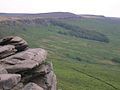
Stanage Edge, or simply Stanage is a gritstone escarpment in the Peak District, famous as a location for climbing. It marks a county boundary and the sudden edge of the Peak District: behind the edge are the roughhills and dales of the Peak in Derbyshire, but from the foot of the edge north-eastwards stretch the Hallam Moors of West Riding of Yorkshire.
The name 'Stanage' is from "stone edge", so the longer form is etymologically tautologous.
The highest point of Stanage Edge is High Neb at 1,503 feet above sea level. Areas of Stanage were quarried in the past to produce grindstones, and some can still be seen on the hillside—carved, but never removed.
A paved packhorse road ran along the top of the edge, and remains of it can be seen, as can remains of the Long Causeway, a Roman road which works its way over the edge on its route from Templeborough to Brough in the Hope Valley, crossing Hallam Moor and passing Stanedge Pole, an ancient waymarker on the route to Sheffield. Some cairns along the top are even older, and there is a well-known cave in the cliff known as Robin Hood's Cave. More recent features include early 20th-century drinking basins, designed to collect pure rainwater for grouse to drink.
Stanage is a magnet for climbers and ramblers in addition to runners. The Stanage Struggle is a popular local fell race that starts in nearby Hathersage and rises to High Neb before returning to the village 500 feet below.
Rock climbing

Stanage's naturally weathered Millstone Grit face is now known as a highly popular location for rock climbing in the Peak District. The edge runs three miles north from the Cowper Stone to Stanage End. It is the northernmost of an almost continuous line of cliffs, including Burbage Rocks, Froggatt Edge, Curbar Edge, Baslow Edge and Birchen Edge. The Cowper Stone is a block of gritstone at the most southerly point of Stanage. Set alone a few hundred yards from the last buttress of the main crag, it is a large boulder with distinctive rounded breaks running across it.[1] It is the scene of some classic hard-grit routes of the 1980s first climbed by protagonists such as Johnny Dawes and John Allen. The Edge was notably omitted from the first rock climbing guidebook to the Peak District, Some Gritstone Climbs by John Laycock, published in 1913, due to the then severe access restrictions to the land. It has subsequently been featured regularly in over a century of regular climbing guidebooks, which document the growth in the number of routes and the rise in climbing standards.
Although the edge reaches only 82 feet in height it is one of the most famous UK climbing venues: aside from having a multitude of routes close to a major population centre, it is home to the route 'Right Unconquerable' (HVS 5a), which, when first climbed by Joe Brown in 1949, was considered a milestone achievement in British climbing. In spite of its height, the edge is home to the longest recorded rock route in the United Kingdom; the 5000 m Girdle Traverse, completed by Ron Fawcett in 1992 and graded "E5 6b(ish)".[2]
Gallery
-
 The Cowper Stone
 -

-


See also
Outside links
| ("Wikimedia Commons" has material about Stanage Edge) |
References
- ↑ Rockfax page on the Cowperstone
- ↑ Stanage (BMC Guide), David Simmonite et al, (2002) ISBN 0-903908-42-5